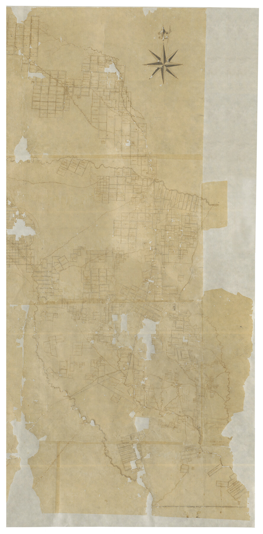
Map of Nacogdoches County
-
Map/Doc
93371
-
Collection
General Map Collection
-
Object Dates
[1839 ca.] (Creation Date)
-
Counties
Nacogdoches
-
Subjects
County
-
Height x Width
83.6 x 41.6 inches
212.3 x 105.7 cm
-
Comments
East half of map. For west half see map 93370. For digital composite of both halves see 16775. Covers much of East Texas.
Adopted by The Summerlee Foundation. Conservation funded in 2004. Digitized in 2012 with a generous grant from the Summerlee Foundation.
Related maps
Map of Nacogdoches County

Print $40.00
- Digital $50.00
Map of Nacogdoches County
1839
Size 83.3 x 79.2 inches
Map/Doc 16775
Map of Nacogdoches County

Print $40.00
- Digital $50.00
Map of Nacogdoches County
1839
Size 83.6 x 43.2 inches
Map/Doc 93370
Part of: General Map Collection
Morris County Rolled Sketch 2A

Print $20.00
- Digital $50.00
Morris County Rolled Sketch 2A
Size 24.4 x 19.2 inches
Map/Doc 10271
Randall County Rolled Sketch 8

Print $20.00
- Digital $50.00
Randall County Rolled Sketch 8
Size 16.1 x 29.8 inches
Map/Doc 7430
Map of Hall County

Print $20.00
- Digital $50.00
Map of Hall County
1900
Size 41.2 x 41.3 inches
Map/Doc 16842
Eastland County Working Sketch 53

Print $20.00
- Digital $50.00
Eastland County Working Sketch 53
1982
Size 22.9 x 27.4 inches
Map/Doc 68834
Scurry County Rolled Sketch 2A

Print $20.00
- Digital $50.00
Scurry County Rolled Sketch 2A
Size 25.6 x 24.2 inches
Map/Doc 7764
McLennan County Sketch File 31

Print $22.00
- Digital $50.00
McLennan County Sketch File 31
Size 14.2 x 17.2 inches
Map/Doc 31306
Reagan County Sketch File 2B

Print $20.00
- Digital $50.00
Reagan County Sketch File 2B
Size 20.4 x 22.2 inches
Map/Doc 12212
Tom Green County Boundary File 2

Print $50.00
- Digital $50.00
Tom Green County Boundary File 2
Size 14.5 x 9.0 inches
Map/Doc 59335
Menard County

Print $20.00
- Digital $50.00
Menard County
1942
Size 43.6 x 47.7 inches
Map/Doc 77371
Starr County Working Sketch 16

Print $20.00
- Digital $50.00
Starr County Working Sketch 16
1981
Size 21.5 x 12.0 inches
Map/Doc 63932
Brewster County Rolled Sketch 101

Print $40.00
- Digital $50.00
Brewster County Rolled Sketch 101
1927
Size 63.0 x 46.2 inches
Map/Doc 10648
Amistad International Reservoir on Rio Grande 72a

Print $20.00
- Digital $50.00
Amistad International Reservoir on Rio Grande 72a
1949
Size 28.3 x 39.6 inches
Map/Doc 73361
You may also like
Comanche County Working Sketch 13

Print $20.00
- Digital $50.00
Comanche County Working Sketch 13
1957
Size 18.4 x 15.0 inches
Map/Doc 68147
That part of the boundary between the Republic of Texas and the United States, North of Sabine River from the 36th to the 72nd Mile Mound on the Meridian Line (Sheet No. 2)

Print $20.00
- Digital $50.00
That part of the boundary between the Republic of Texas and the United States, North of Sabine River from the 36th to the 72nd Mile Mound on the Meridian Line (Sheet No. 2)
1842
Size 33.7 x 26.0 inches
Map/Doc 3132
Val Verde Co.

Print $20.00
- Digital $50.00
Val Verde Co.
1908
Size 39.8 x 38.7 inches
Map/Doc 63100
[H. & G. N. RR. Company, Block 7]
![91018, [H. & G. N. RR. Company, Block 7], Twichell Survey Records](https://historictexasmaps.com/wmedia_w700/maps/91018-1.tif.jpg)
Print $20.00
- Digital $50.00
[H. & G. N. RR. Company, Block 7]
Size 14.7 x 21.4 inches
Map/Doc 91018
Sterling County Rolled Sketch 25

Print $20.00
- Digital $50.00
Sterling County Rolled Sketch 25
Size 31.4 x 35.3 inches
Map/Doc 9955
Roberts County Working Sketch 21

Print $20.00
- Digital $50.00
Roberts County Working Sketch 21
1979
Size 35.7 x 45.6 inches
Map/Doc 63547
Right-of-Way and Track Map, Texas State Railroad operated by the T. and N.O. R.R. Co.

Print $40.00
- Digital $50.00
Right-of-Way and Track Map, Texas State Railroad operated by the T. and N.O. R.R. Co.
1917
Size 24.7 x 56.0 inches
Map/Doc 64172
Flight Mission No. DIX-7P, Frame 15, Aransas County

Print $20.00
- Digital $50.00
Flight Mission No. DIX-7P, Frame 15, Aransas County
1956
Size 18.8 x 22.8 inches
Map/Doc 83867
Fort Bend County Working Sketch 3

Print $20.00
- Digital $50.00
Fort Bend County Working Sketch 3
1897
Size 26.8 x 24.6 inches
Map/Doc 69209
Karnes County Sketch File 17

Print $4.00
- Digital $50.00
Karnes County Sketch File 17
1873
Size 12.8 x 8.0 inches
Map/Doc 28622

Edwards County Working Sketch 123

Print $20.00
- Digital $50.00
Edwards County Working Sketch 123
1976
Size 18.3 x 25.2 inches
Map/Doc 68999