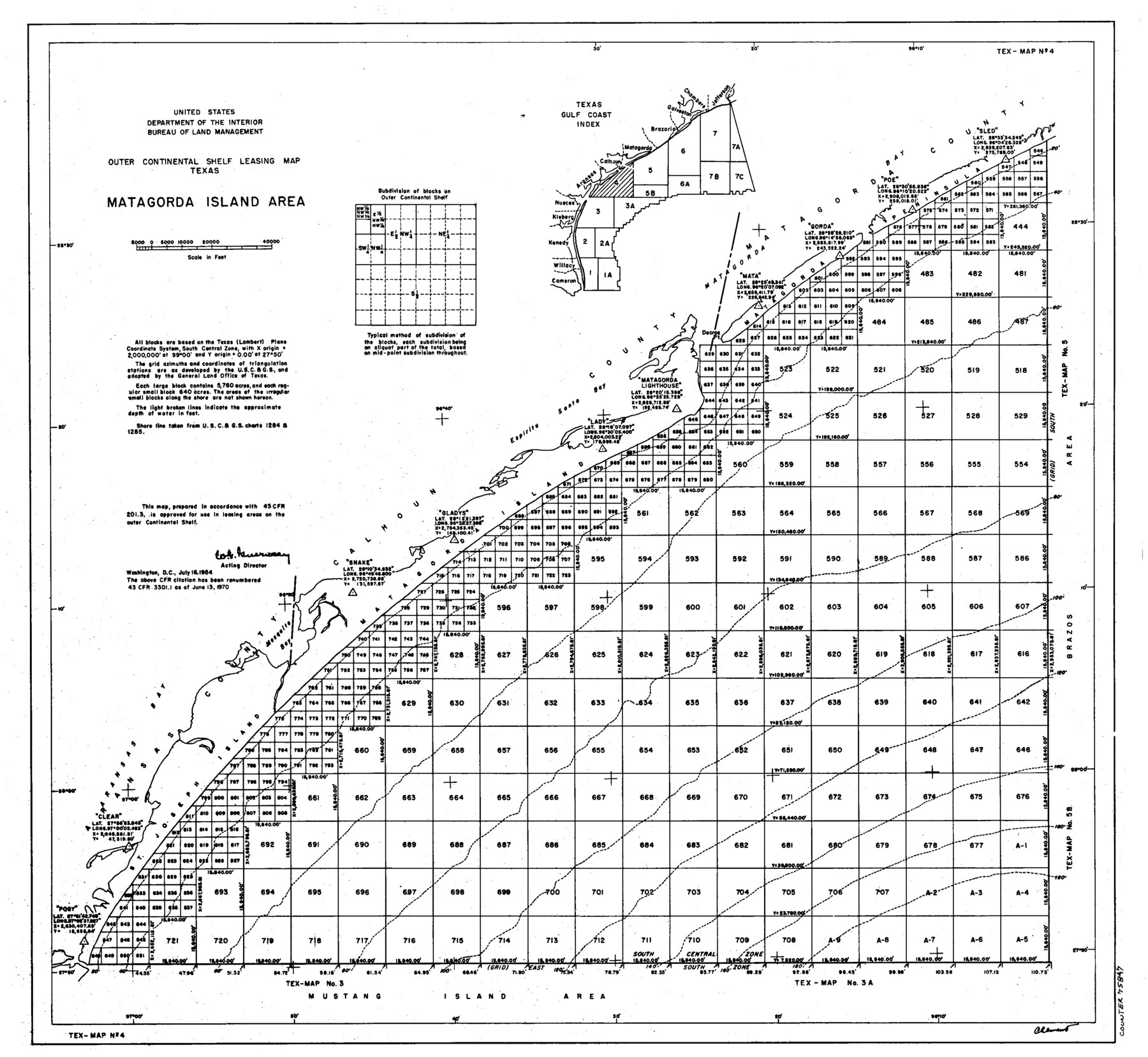
Outer Continental Shelf Leasing Maps (Texas Offshore Operations)
D-7-1; D-7-2
-
Map/Doc
75847
-
Collection
General Map Collection
-
Subjects
Energy Offshore Submerged Area
-
Height x Width
17.0 x 18.4 inches
43.2 x 46.7 cm
Part of: General Map Collection
Bee County Sketch File 31

Print $6.00
- Digital $50.00
Bee County Sketch File 31
1886
Size 12.8 x 8.2 inches
Map/Doc 14344
Corpus Christi Harbor

Print $40.00
- Digital $50.00
Corpus Christi Harbor
1975
Size 37.6 x 51.5 inches
Map/Doc 73479
Val Verde County Working Sketch 47

Print $20.00
- Digital $50.00
Val Verde County Working Sketch 47
1946
Size 41.4 x 42.6 inches
Map/Doc 72182
Harbor Pass and Bar at Brazos Santiago, Texas

Print $20.00
- Digital $50.00
Harbor Pass and Bar at Brazos Santiago, Texas
1871
Size 18.1 x 27.4 inches
Map/Doc 73038
Brazoria County Working Sketch 34

Print $20.00
- Digital $50.00
Brazoria County Working Sketch 34
1981
Size 15.8 x 19.0 inches
Map/Doc 67519
Map of Wood County

Print $20.00
- Digital $50.00
Map of Wood County
1877
Size 16.8 x 17.1 inches
Map/Doc 4168
Comanche County Boundary File 2c

Print $8.00
- Digital $50.00
Comanche County Boundary File 2c
Size 14.3 x 8.9 inches
Map/Doc 51796
Borden County Boundary File 2

Print $22.00
- Digital $50.00
Borden County Boundary File 2
Size 13.6 x 8.7 inches
Map/Doc 50614
Hockley County Boundary File 1

Print $8.00
- Digital $50.00
Hockley County Boundary File 1
Size 13.5 x 8.5 inches
Map/Doc 54798
Presidio County Working Sketch 44

Print $20.00
- Digital $50.00
Presidio County Working Sketch 44
1949
Size 29.8 x 20.6 inches
Map/Doc 71721
Gregg County Working Sketch 3

Print $20.00
- Digital $50.00
Gregg County Working Sketch 3
1931
Size 18.6 x 14.2 inches
Map/Doc 63269
Wilbarger County Rolled Sketch 10

Print $20.00
- Digital $50.00
Wilbarger County Rolled Sketch 10
1983
Size 37.6 x 23.8 inches
Map/Doc 8259
You may also like
Reeves County

Print $40.00
- Digital $50.00
Reeves County
1945
Size 49.4 x 40.8 inches
Map/Doc 95624
Jack County Sketch File 34

Print $20.00
- Digital $50.00
Jack County Sketch File 34
1951
Size 21.2 x 29.3 inches
Map/Doc 11832
Harris County Sketch File 32

Print $14.00
- Digital $50.00
Harris County Sketch File 32
1900
Size 6.7 x 8.8 inches
Map/Doc 25429
Texas and Northern Mexico

Print $20.00
- Digital $50.00
Texas and Northern Mexico
1900
Size 21.6 x 28.6 inches
Map/Doc 95895
Taylor County Rolled Sketch 24

Print $20.00
- Digital $50.00
Taylor County Rolled Sketch 24
Size 19.6 x 22.7 inches
Map/Doc 7916
Brewster County Working Sketch 12

Print $20.00
- Digital $50.00
Brewster County Working Sketch 12
1924
Size 36.9 x 21.4 inches
Map/Doc 67545
J. De Cordova's Map of the State of Texas Compiled from the records of the General Land Office of the State

Print $20.00
- Digital $50.00
J. De Cordova's Map of the State of Texas Compiled from the records of the General Land Office of the State
1867
Size 38.0 x 35.4 inches
Map/Doc 93759
Flight Mission No. CLL-3N, Frame 33, Willacy County

Print $20.00
- Digital $50.00
Flight Mission No. CLL-3N, Frame 33, Willacy County
1954
Size 18.6 x 22.3 inches
Map/Doc 87090
Runnels County Rolled Sketch 34

Print $20.00
- Digital $50.00
Runnels County Rolled Sketch 34
1950
Size 30.8 x 35.5 inches
Map/Doc 7521
Dominguez Empresario Colony. February 6, 1829

Print $20.00
Dominguez Empresario Colony. February 6, 1829
2020
Size 17.2 x 21.7 inches
Map/Doc 95992
Flight Mission No. BRE-1P, Frame 10, Nueces County

Print $20.00
- Digital $50.00
Flight Mission No. BRE-1P, Frame 10, Nueces County
1956
Size 18.4 x 22.5 inches
Map/Doc 86618
