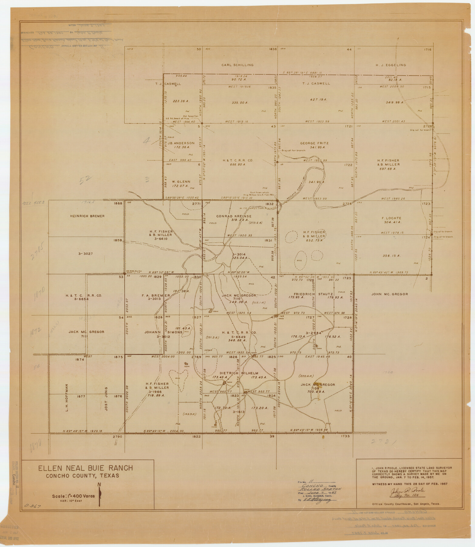
Concho County Rolled Sketch 11
Ellen Neal Buie Ranch, Concho County, Texas
-
Map/Doc
5569
-
Collection
General Map Collection
-
Object Dates
1957/2/28 (Creation Date)
1957/6/7 (File Date)
-
People and Organizations
John P. Poole (Surveyor/Engineer)
-
Counties
Concho
-
Subjects
Surveying Rolled Sketch
-
Height x Width
29.5 x 34.5 inches
74.9 x 87.6 cm
-
Medium
van dyke/brownline/sepia
-
Scale
1" = 400 varas
Part of: General Map Collection
Flight Mission No. DAG-26K, Frame 59, Matagorda County

Print $20.00
- Digital $50.00
Flight Mission No. DAG-26K, Frame 59, Matagorda County
1953
Size 18.5 x 22.3 inches
Map/Doc 86579
Map of Northern Boundary Line of Texas and Pacific 80 Mile Reservation

Print $20.00
- Digital $50.00
Map of Northern Boundary Line of Texas and Pacific 80 Mile Reservation
1902
Size 16.8 x 16.7 inches
Map/Doc 65694
Val Verde County Working Sketch 50

Print $20.00
- Digital $50.00
Val Verde County Working Sketch 50
1950
Size 27.9 x 28.0 inches
Map/Doc 72185
Starr County Rolled Sketch 44

Print $20.00
- Digital $50.00
Starr County Rolled Sketch 44
Size 38.0 x 46.0 inches
Map/Doc 9943
Newton County Working Sketch 13

Print $20.00
- Digital $50.00
Newton County Working Sketch 13
1946
Size 34.4 x 34.2 inches
Map/Doc 71259
Collingsworth County Sketch File 10

Print $4.00
- Digital $50.00
Collingsworth County Sketch File 10
1892
Size 11.3 x 9.0 inches
Map/Doc 18891
Lynn County Rolled Sketch A

Print $20.00
- Digital $50.00
Lynn County Rolled Sketch A
1901
Size 33.5 x 34.2 inches
Map/Doc 9471
D No. 4 - Reconnaissance of New River and Bar, North Carolina

Print $20.00
- Digital $50.00
D No. 4 - Reconnaissance of New River and Bar, North Carolina
1852
Size 19.4 x 15.7 inches
Map/Doc 97211
Hunt County Sketch File 4a

Print $4.00
- Digital $50.00
Hunt County Sketch File 4a
1859
Size 12.6 x 8.2 inches
Map/Doc 27089
University Lands, Block 35, Crane & Ector Counties

Print $20.00
- Digital $50.00
University Lands, Block 35, Crane & Ector Counties
1935
Size 39.9 x 45.5 inches
Map/Doc 2406

Gray's New Map of Texas and the Indian Territory

Print $20.00
- Digital $50.00
Gray's New Map of Texas and the Indian Territory
1876
Size 17.4 x 27.7 inches
Map/Doc 93786
You may also like
Hardin County Working Sketch 43

Print $20.00
- Digital $50.00
Hardin County Working Sketch 43
2001
Size 45.4 x 37.4 inches
Map/Doc 83572
Flight Mission No. BRA-7M, Frame 41, Jefferson County

Print $20.00
- Digital $50.00
Flight Mission No. BRA-7M, Frame 41, Jefferson County
1953
Size 18.6 x 22.3 inches
Map/Doc 85492
Atascosa County Rolled Sketch 15

Print $20.00
- Digital $50.00
Atascosa County Rolled Sketch 15
1945
Size 45.2 x 42.7 inches
Map/Doc 8433
Angelina County Working Sketch 2

Print $20.00
- Digital $50.00
Angelina County Working Sketch 2
1899
Size 18.3 x 23.4 inches
Map/Doc 67082
Val Verde County Sketch File 41

Print $20.00
- Digital $50.00
Val Verde County Sketch File 41
1938
Size 17.8 x 22.7 inches
Map/Doc 12583
Hutchinson County Rolled Sketch 42

Print $40.00
- Digital $50.00
Hutchinson County Rolled Sketch 42
1993
Size 38.5 x 49.9 inches
Map/Doc 6309
Cameron County NRC Article 33.136 Sketch 2

Print $20.00
- Digital $50.00
Cameron County NRC Article 33.136 Sketch 2
2002
Size 24.4 x 35.9 inches
Map/Doc 77040
Henderson County Working Sketch 10

Print $20.00
- Digital $50.00
Henderson County Working Sketch 10
1925
Size 29.7 x 18.8 inches
Map/Doc 66143
Ramsey State Farm of the Texas Prison System, Brazoria County

Print $4.00
- Digital $50.00
Ramsey State Farm of the Texas Prison System, Brazoria County
1932
Size 15.9 x 18.6 inches
Map/Doc 65273
Texas Gulf Coast Map from the Sabine River to the Rio Grande as subdivided for mineral development

Print $20.00
- Digital $50.00
Texas Gulf Coast Map from the Sabine River to the Rio Grande as subdivided for mineral development
1948
Size 41.6 x 39.2 inches
Map/Doc 2904
Sherman County Boundary File 1

Print $20.00
- Digital $50.00
Sherman County Boundary File 1
Size 11.4 x 8.9 inches
Map/Doc 58751
Map of the Aransas Pass Transit Railway

Print $40.00
- Digital $50.00
Map of the Aransas Pass Transit Railway
1890
Size 23.9 x 60.9 inches
Map/Doc 64369