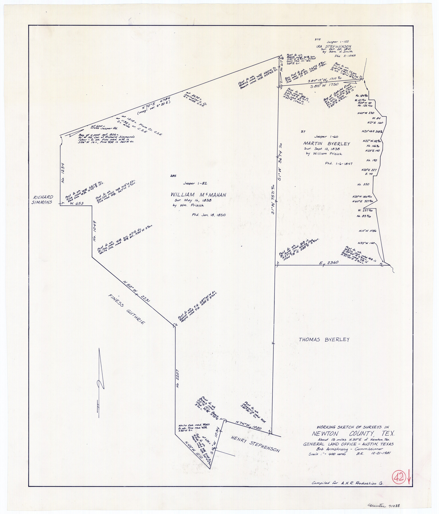
Newton County Working Sketch 42
-
Map/Doc
71288
-
Collection
General Map Collection
-
Object Dates
12/21/1981 (Creation Date)
-
People and Organizations
Beverly Robison (Draftsman)
-
Counties
Newton
-
Subjects
Surveying Working Sketch
-
Height x Width
26.4 x 22.5 inches
67.1 x 57.2 cm
-
Scale
1" = 400 varas
Part of: General Map Collection
Brewster County Rolled Sketch 66

Print $20.00
- Digital $50.00
Brewster County Rolled Sketch 66
1940
Size 33.0 x 36.2 inches
Map/Doc 8490
Borden County Sketch File 4

Print $24.00
- Digital $50.00
Borden County Sketch File 4
1903
Size 8.8 x 7.8 inches
Map/Doc 14707
Millennium in Maps - Exploration

Millennium in Maps - Exploration
Size 20.6 x 31.5 inches
Map/Doc 95931
Calhoun County Aerial Photograph Index Sheet 2

Print $20.00
- Digital $50.00
Calhoun County Aerial Photograph Index Sheet 2
1953
Size 24.1 x 19.8 inches
Map/Doc 83671
Preliminary survey of the entrance to the Rio Grande, Texas

Print $20.00
- Digital $50.00
Preliminary survey of the entrance to the Rio Grande, Texas
1854
Size 18.3 x 24.5 inches
Map/Doc 73005
Flight Mission No. DQN-6K, Frame 9, Calhoun County

Print $20.00
- Digital $50.00
Flight Mission No. DQN-6K, Frame 9, Calhoun County
1953
Size 18.5 x 22.1 inches
Map/Doc 84431
Val Verde County Working Sketch 26

Print $20.00
- Digital $50.00
Val Verde County Working Sketch 26
1936
Size 22.9 x 31.5 inches
Map/Doc 72161
Sutton County Working Sketch 39

Print $20.00
- Digital $50.00
Sutton County Working Sketch 39
1945
Size 29.6 x 25.8 inches
Map/Doc 62382
Val Verde County Working Sketch 46

Print $20.00
- Digital $50.00
Val Verde County Working Sketch 46
1946
Size 31.8 x 33.3 inches
Map/Doc 72181
Burleson County Working Sketch 32

Print $20.00
- Digital $50.00
Burleson County Working Sketch 32
1981
Size 26.3 x 13.5 inches
Map/Doc 67751
Kleberg County Rolled Sketch 8

Print $20.00
- Digital $50.00
Kleberg County Rolled Sketch 8
1947
Size 33.0 x 42.0 inches
Map/Doc 9360
Montgomery County Sketch File 6b

Print $40.00
- Digital $50.00
Montgomery County Sketch File 6b
Size 12.8 x 16.2 inches
Map/Doc 31783
You may also like
Corpus Christi Bay

Print $20.00
- Digital $50.00
Corpus Christi Bay
1971
Size 36.2 x 47.6 inches
Map/Doc 73473
Flight Mission No. BRE-2P, Frame 13, Nueces County

Print $20.00
- Digital $50.00
Flight Mission No. BRE-2P, Frame 13, Nueces County
1956
Size 18.0 x 22.1 inches
Map/Doc 86722
Starr County Rolled Sketch X

Print $121.00
- Digital $50.00
Starr County Rolled Sketch X
Size 13.3 x 8.1 inches
Map/Doc 75961
Jackson County Working Sketch 11

Print $40.00
- Digital $50.00
Jackson County Working Sketch 11
1994
Size 33.8 x 48.4 inches
Map/Doc 66459
[Texas Gulf Coast from Rio Grande to Sabine Lake]
![72687, [Texas Gulf Coast from Rio Grande to Sabine Lake], General Map Collection](https://historictexasmaps.com/wmedia_w700/maps/72687.tif.jpg)
Print $20.00
- Digital $50.00
[Texas Gulf Coast from Rio Grande to Sabine Lake]
Size 28.1 x 18.3 inches
Map/Doc 72687
Culberson County Rolled Sketch 52

Print $20.00
- Digital $50.00
Culberson County Rolled Sketch 52
Size 19.2 x 25.1 inches
Map/Doc 5674
[Leagues 247, 320, and 321]
![91290, [Leagues 247, 320, and 321], Twichell Survey Records](https://historictexasmaps.com/wmedia_w700/maps/91290-1.tif.jpg)
Print $2.00
- Digital $50.00
[Leagues 247, 320, and 321]
Size 7.8 x 14.5 inches
Map/Doc 91290
Explorations of the Louisiana Purchase

Explorations of the Louisiana Purchase
2023
Size 8.5 x 11.0 inches
Map/Doc 97183
Galveston County Sketch File 73h

Print $20.00
- Digital $50.00
Galveston County Sketch File 73h
Size 29.4 x 36.8 inches
Map/Doc 10461
Garza County Working Sketch 4

Print $20.00
- Digital $50.00
Garza County Working Sketch 4
1916
Size 19.5 x 23.1 inches
Map/Doc 63151
Flight Mission No. DCL-6C, Frame 122, Kenedy County

Print $20.00
- Digital $50.00
Flight Mission No. DCL-6C, Frame 122, Kenedy County
1943
Size 18.5 x 22.4 inches
Map/Doc 85952
Lynn County Rolled Sketch 12

Print $20.00
- Digital $50.00
Lynn County Rolled Sketch 12
1956
Size 35.0 x 24.5 inches
Map/Doc 6648