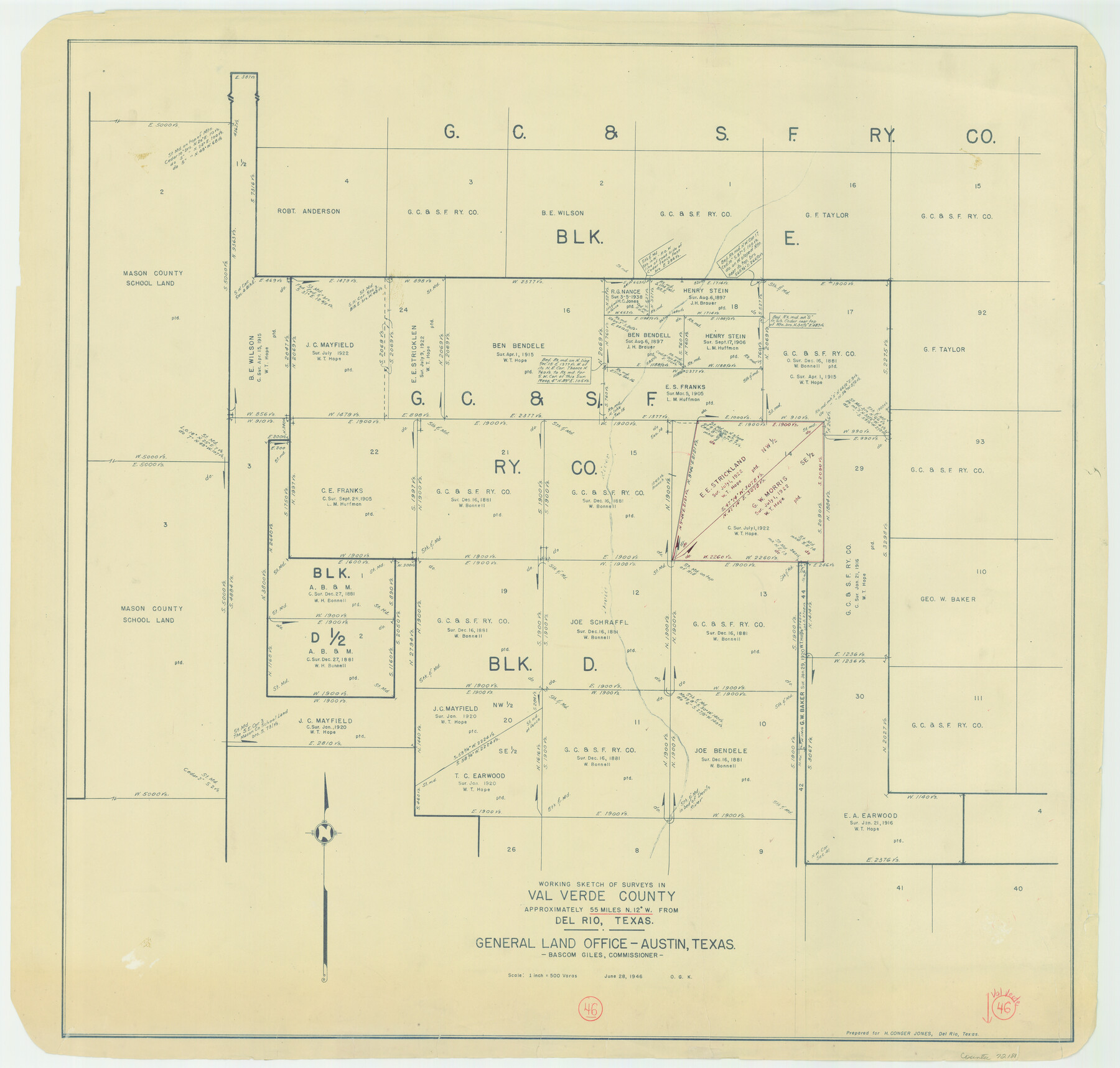
Val Verde County Working Sketch 46
-
Map/Doc
72181
-
Collection
General Map Collection
-
Object Dates
6/28/1946 (Creation Date)
-
People and Organizations
Otto G. Kurio (Draftsman)
-
Counties
Val Verde
-
Subjects
Surveying Working Sketch
-
Height x Width
31.8 x 33.3 inches
80.8 x 84.6 cm
-
Scale
1" = 500 varas
Part of: General Map Collection
Flight Mission No. CGI-3N, Frame 166, Cameron County

Print $20.00
- Digital $50.00
Flight Mission No. CGI-3N, Frame 166, Cameron County
1954
Size 18.6 x 22.2 inches
Map/Doc 84630

Harris County Working Sketch 14

Print $20.00
- Digital $50.00
Harris County Working Sketch 14
Size 18.9 x 17.4 inches
Map/Doc 65906
Stonewall County Working Sketch 33

Print $40.00
- Digital $50.00
Stonewall County Working Sketch 33
1984
Size 70.4 x 42.8 inches
Map/Doc 62340
Map and Profile of the Denison and Pacific Railway from Denison to Whitesboro

Print $40.00
- Digital $50.00
Map and Profile of the Denison and Pacific Railway from Denison to Whitesboro
1878
Size 42.5 x 57.5 inches
Map/Doc 64284
Cameron County Sketch File 8b

Print $145.00
- Digital $50.00
Cameron County Sketch File 8b
Size 14.0 x 8.5 inches
Map/Doc 17137
Johnson County

Print $20.00
- Digital $50.00
Johnson County
1943
Size 43.3 x 40.2 inches
Map/Doc 95549
Coleman County Working Sketch 23

Print $20.00
- Digital $50.00
Coleman County Working Sketch 23
1958
Size 30.4 x 29.5 inches
Map/Doc 68276
Rio Grande - North Extension Raymondville Sheet

Print $40.00
- Digital $50.00
Rio Grande - North Extension Raymondville Sheet
1937
Size 16.4 x 56.9 inches
Map/Doc 65104
Kleberg County Rolled Sketch 10-16

Print $20.00
- Digital $50.00
Kleberg County Rolled Sketch 10-16
1952
Size 37.0 x 33.2 inches
Map/Doc 9381
Flight Mission No. CRE-1R, Frame 123, Jackson County

Print $20.00
- Digital $50.00
Flight Mission No. CRE-1R, Frame 123, Jackson County
1956
Size 16.0 x 16.0 inches
Map/Doc 85334
McMullen County Working Sketch 43

Print $20.00
- Digital $50.00
McMullen County Working Sketch 43
1980
Size 35.2 x 28.1 inches
Map/Doc 70744
You may also like
General Highway Map, Bailey County, Texas

Print $20.00
General Highway Map, Bailey County, Texas
1940
Size 25.1 x 18.3 inches
Map/Doc 79010
Lipscomb County Rolled Sketch 5

Print $20.00
- Digital $50.00
Lipscomb County Rolled Sketch 5
1941
Size 45.8 x 23.3 inches
Map/Doc 9451
Flight Mission No. CGI-4N, Frame 175, Cameron County

Print $20.00
- Digital $50.00
Flight Mission No. CGI-4N, Frame 175, Cameron County
1955
Size 18.6 x 22.4 inches
Map/Doc 84678
North Portion of Lavaca Bay and Vicinity, showing Subdivision for Mineral Development

Print $20.00
- Digital $50.00
North Portion of Lavaca Bay and Vicinity, showing Subdivision for Mineral Development
1946
Size 33.8 x 37.1 inches
Map/Doc 1911
Mills County Boundary File 2

Print $6.00
- Digital $50.00
Mills County Boundary File 2
Size 14.1 x 8.7 inches
Map/Doc 57278
Kendall County Rolled Sketch 6

Print $20.00
- Digital $50.00
Kendall County Rolled Sketch 6
Size 29.6 x 39.4 inches
Map/Doc 6459
Liberty County Working Sketch Graphic Index - west part

Print $20.00
- Digital $50.00
Liberty County Working Sketch Graphic Index - west part
1977
Size 45.7 x 34.5 inches
Map/Doc 76619
Young County Working Sketch 6

Print $20.00
- Digital $50.00
Young County Working Sketch 6
1919
Size 12.2 x 11.9 inches
Map/Doc 62029
Map of Brown County

Print $20.00
- Digital $50.00
Map of Brown County
1876
Size 25.9 x 23.3 inches
Map/Doc 3341
Starr County Sketch File 21

Print $52.00
- Digital $50.00
Starr County Sketch File 21
1912
Size 14.2 x 8.7 inches
Map/Doc 36889
Roberts County Boundary File 2a

Print $10.00
- Digital $50.00
Roberts County Boundary File 2a
Size 9.5 x 6.4 inches
Map/Doc 58339
Presidio County Working Sketch 21

Print $20.00
- Digital $50.00
Presidio County Working Sketch 21
1945
Size 25.4 x 35.9 inches
Map/Doc 71697