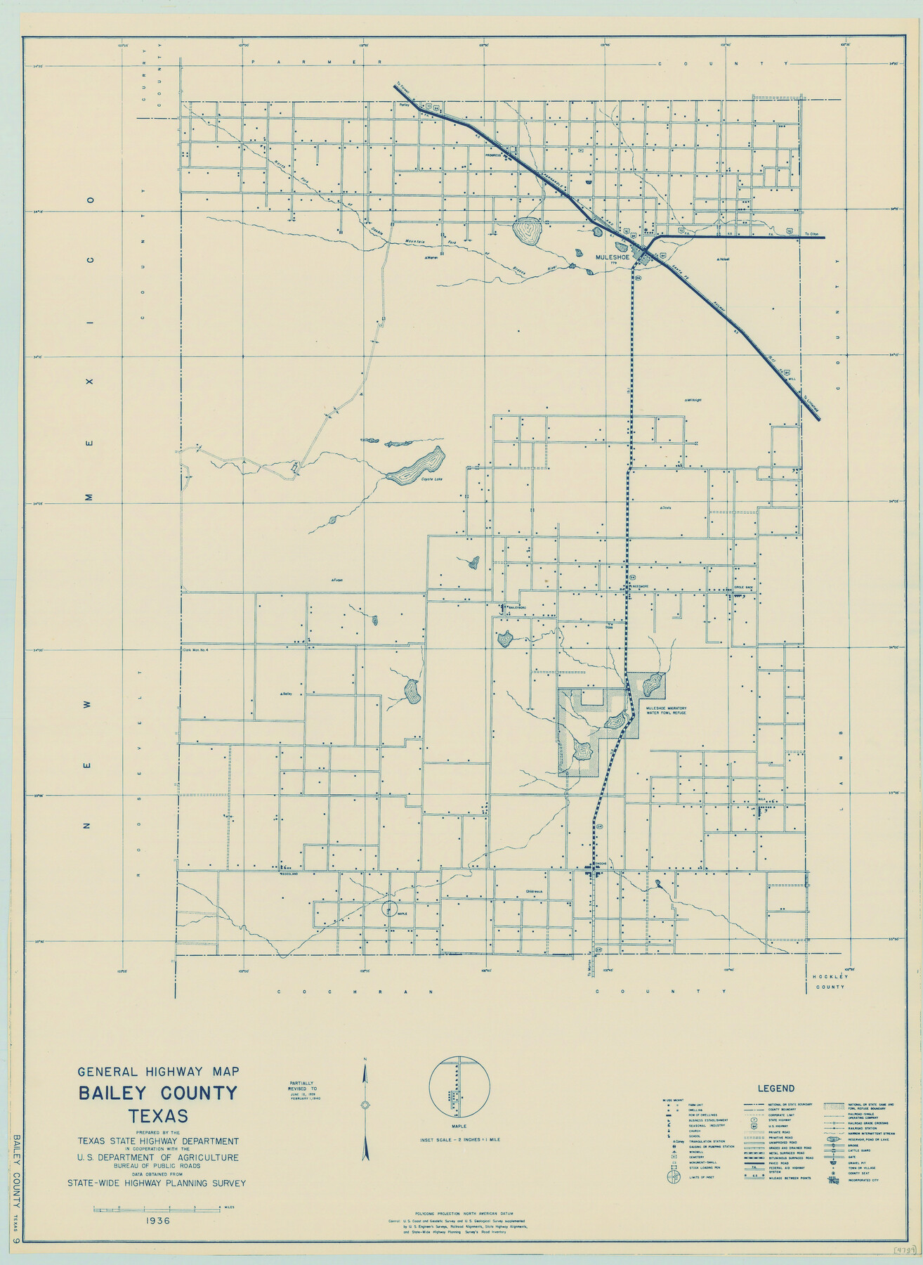
General Highway Map, Bailey County, Texas
-
Map/Doc
79010
-
Collection
Texas State Library and Archives
-
Object Dates
2/1/1940 (Creation Date)
-
People and Organizations
Texas State Highway Department (Publisher)
-
Counties
Bailey
-
Subjects
County
-
Height x Width
25.1 x 18.3 inches
63.8 x 46.5 cm
-
Comments
Prints available courtesy of the Texas State Library and Archives.
More info can be found here: TSLAC Map 04789
Part of: Texas State Library and Archives
General Highway Map. Detail of Cities and Towns in Tarrant County, Texas [Fort Worth and vicinity]
![79252, General Highway Map. Detail of Cities and Towns in Tarrant County, Texas [Fort Worth and vicinity], Texas State Library and Archives](https://historictexasmaps.com/wmedia_w700/maps/79252-GC.tif.jpg)
Print $20.00
General Highway Map. Detail of Cities and Towns in Tarrant County, Texas [Fort Worth and vicinity]
1940
Size 24.9 x 18.2 inches
Map/Doc 79252
General Highway Map, Red River County, Texas

Print $20.00
General Highway Map, Red River County, Texas
1961
Size 24.6 x 18.1 inches
Map/Doc 79637
Map of the River Sabine from its Mouth on the Gulf of Mexico in the Sea to Logan's Ferry in Latitude 31° 58' 25" North

Print $20.00
Map of the River Sabine from its Mouth on the Gulf of Mexico in the Sea to Logan's Ferry in Latitude 31° 58' 25" North
1840
Size 35.5 x 9.1 inches
Map/Doc 79294
General Highway Map, Knox County, Texas

Print $20.00
General Highway Map, Knox County, Texas
1961
Size 18.2 x 24.9 inches
Map/Doc 79560
General Highway Map, San Saba County, Texas

Print $20.00
General Highway Map, San Saba County, Texas
1961
Size 18.3 x 24.5 inches
Map/Doc 79648
General Highway Map. Detail of Cities and Towns in Harris County, Texas. City Map [of] Houston, Pasadena, West University Place, Bellaire, Galena Park, Jacinto City, South Houston, South Side Place, Deer Park, and vicinity, Harris County, Texas
![79504, General Highway Map. Detail of Cities and Towns in Harris County, Texas. City Map [of] Houston, Pasadena, West University Place, Bellaire, Galena Park, Jacinto City, South Houston, South Side Place, Deer Park, and vicinity, Harris County, Texas, Texas State Library and Archives](https://historictexasmaps.com/wmedia_w700/maps/79504.tif.jpg)
Print $20.00
General Highway Map. Detail of Cities and Towns in Harris County, Texas. City Map [of] Houston, Pasadena, West University Place, Bellaire, Galena Park, Jacinto City, South Houston, South Side Place, Deer Park, and vicinity, Harris County, Texas
1961
Size 18.1 x 24.8 inches
Map/Doc 79504
Topographic Map of Big Bend Area

Print $20.00
Topographic Map of Big Bend Area
1923
Size 47.1 x 35.0 inches
Map/Doc 79757
General Highway Map, Fayette County, Texas

Print $20.00
General Highway Map, Fayette County, Texas
1940
Size 18.5 x 25.0 inches
Map/Doc 79089
Map Showing Proposed System of State Highways as Adopted June 1917

Print $20.00
Map Showing Proposed System of State Highways as Adopted June 1917
1917
Size 20.9 x 22.4 inches
Map/Doc 76294
General Highway Map, El Paso County, Texas

Print $20.00
General Highway Map, El Paso County, Texas
1961
Size 18.1 x 24.5 inches
Map/Doc 79456
General Highway Map, Detail of Cities and Towns in Delta County, Hopkins County [Cooper and vicinity]
![79440, General Highway Map, Detail of Cities and Towns in Delta County, Hopkins County [Cooper and vicinity], Texas State Library and Archives](https://historictexasmaps.com/wmedia_w700/maps/79440.tif.jpg)
Print $20.00
General Highway Map, Detail of Cities and Towns in Delta County, Hopkins County [Cooper and vicinity]
1961
Size 18.2 x 24.4 inches
Map/Doc 79440
General Highway Map, Ellis County, Texas

Print $20.00
General Highway Map, Ellis County, Texas
1939
Size 18.4 x 24.9 inches
Map/Doc 79083
You may also like
Pecos County Working Sketch 39

Print $20.00
- Digital $50.00
Pecos County Working Sketch 39
1940
Size 37.5 x 37.6 inches
Map/Doc 71511
Hardin County Sketch File 71f

Print $20.00
- Digital $50.00
Hardin County Sketch File 71f
1997
Size 25.2 x 36.7 inches
Map/Doc 11643
Atascosa County Working Sketch 8

Print $20.00
- Digital $50.00
Atascosa County Working Sketch 8
1913
Size 15.5 x 19.8 inches
Map/Doc 67204
Deaf Smith County

Print $40.00
- Digital $50.00
Deaf Smith County
1922
Size 55.0 x 43.9 inches
Map/Doc 89768
Webb County Boundary File 5

Print $165.00
- Digital $50.00
Webb County Boundary File 5
Size 14.2 x 8.8 inches
Map/Doc 59765
Shackelford County Working Sketch 10

Print $20.00
- Digital $50.00
Shackelford County Working Sketch 10
1984
Size 28.8 x 26.1 inches
Map/Doc 63850
Sherman County Rolled Sketch 7

Print $20.00
- Digital $50.00
Sherman County Rolled Sketch 7
1919
Size 32.7 x 19.0 inches
Map/Doc 7787
Calhoun County Rolled Sketch 26

Print $40.00
- Digital $50.00
Calhoun County Rolled Sketch 26
1941
Size 25.5 x 112.1 inches
Map/Doc 8556
Brazoria County Sketch File 57

Print $10.00
- Digital $50.00
Brazoria County Sketch File 57
1940
Size 8.7 x 6.3 inches
Map/Doc 15377
Throckmorton County Rolled Sketch 3

Print $20.00
- Digital $50.00
Throckmorton County Rolled Sketch 3
1987
Size 31.2 x 36.3 inches
Map/Doc 7986
Hemphill County Boundary File 2

Print $54.00
- Digital $50.00
Hemphill County Boundary File 2
Size 8.6 x 32.1 inches
Map/Doc 54621
Texas Urbanization and Population Density

Texas Urbanization and Population Density
1976
Size 19.3 x 23.9 inches
Map/Doc 93729