DeWitt County Rolled Sketch 1
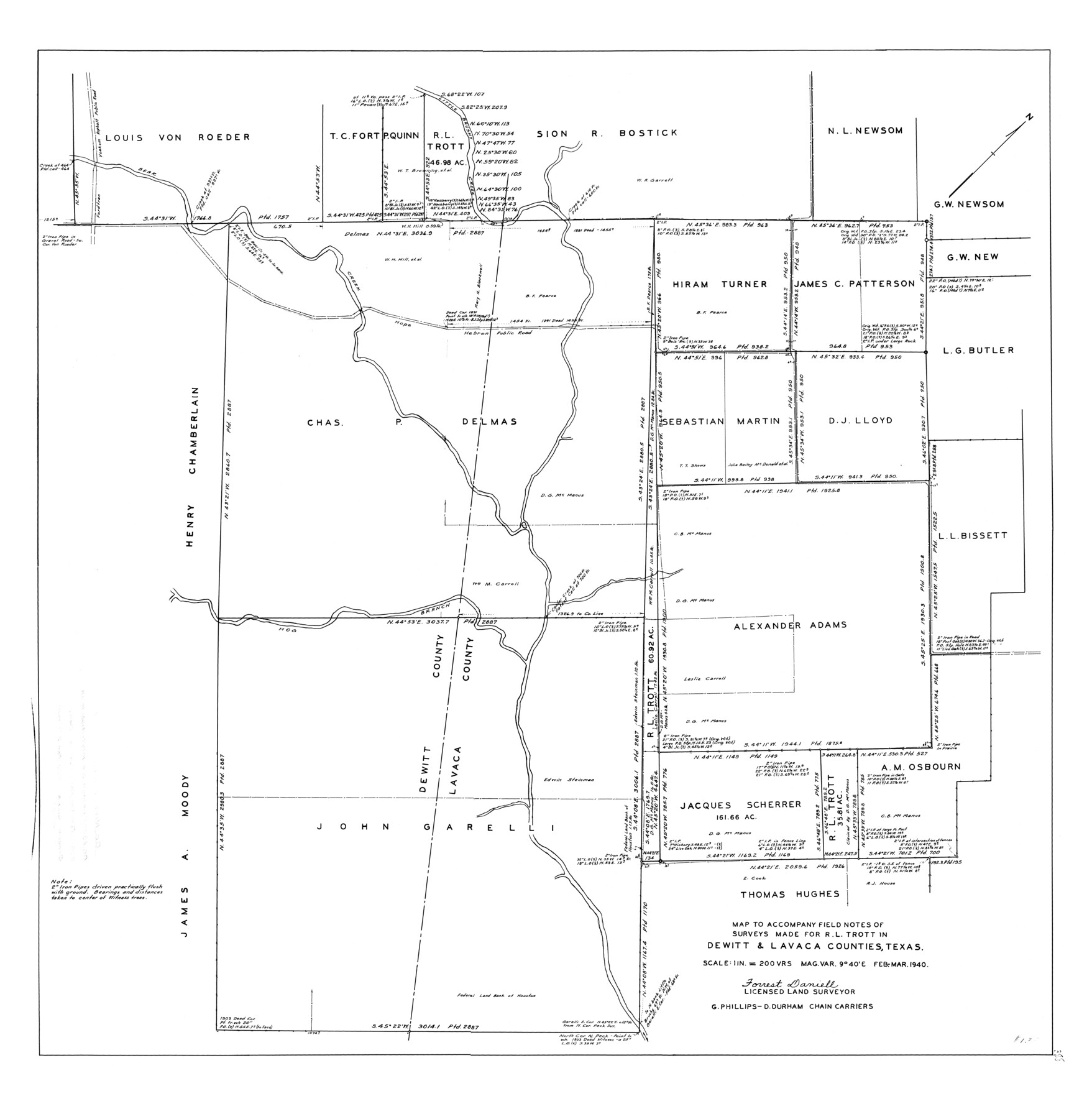
Map to accompany field notes of surveys made for R.L. Trott in DeWitt & Lavaca Counties, Texas
-
Map/Doc
8777
-
Collection
General Map Collection
-
Object Dates
1940 (Creation Date)
1940/3/27 (File Date)
-
People and Organizations
Forrest Daniell (Surveyor/Engineer)
G. Phillips (Chainman/Field Personnel)
D. Durham (Chainman/Field Personnel)
-
Counties
DeWitt Lavaca
-
Subjects
Surveying Rolled Sketch
-
Height x Width
40.5 x 39.5 inches
102.9 x 100.3 cm
-
Scale
1" = 200 varas
Part of: General Map Collection
Baylor County Working Sketch 14

Print $40.00
- Digital $50.00
Baylor County Working Sketch 14
1982
Size 33.5 x 55.1 inches
Map/Doc 67299
Limestone County Working Sketch 26

Print $20.00
- Digital $50.00
Limestone County Working Sketch 26
1982
Size 39.6 x 44.1 inches
Map/Doc 70576
Anderson County Working Sketch 13

Print $20.00
- Digital $50.00
Anderson County Working Sketch 13
1930
Size 34.0 x 21.9 inches
Map/Doc 67013
Duval County Sketch File 52

Print $20.00
- Digital $50.00
Duval County Sketch File 52
1936
Size 21.0 x 28.6 inches
Map/Doc 11402
Polk County Rolled Sketch 23

Print $20.00
- Digital $50.00
Polk County Rolled Sketch 23
Size 29.1 x 23.5 inches
Map/Doc 7313
Flight Mission No. CUG-1P, Frame 76, Kleberg County

Print $20.00
- Digital $50.00
Flight Mission No. CUG-1P, Frame 76, Kleberg County
1956
Size 18.6 x 22.3 inches
Map/Doc 86141
Galveston County Sketch File 11b

Print $4.00
- Digital $50.00
Galveston County Sketch File 11b
1876
Size 8.9 x 8.9 inches
Map/Doc 23378
Schleicher County Working Sketch 21

Print $20.00
- Digital $50.00
Schleicher County Working Sketch 21
1953
Size 26.6 x 10.8 inches
Map/Doc 63823
Reeves County Working Sketch 34

Print $40.00
- Digital $50.00
Reeves County Working Sketch 34
1970
Size 37.9 x 48.9 inches
Map/Doc 63477
Crockett County Rolled Sketch 29

Print $20.00
- Digital $50.00
Crockett County Rolled Sketch 29
1927
Size 22.0 x 36.9 inches
Map/Doc 5781
Flight Mission No. BRA-8M, Frame 116, Jefferson County

Print $20.00
- Digital $50.00
Flight Mission No. BRA-8M, Frame 116, Jefferson County
1953
Size 18.6 x 22.4 inches
Map/Doc 85612
Concho County Sketch File 10

Print $20.00
- Digital $50.00
Concho County Sketch File 10
1887
Size 23.1 x 33.8 inches
Map/Doc 11150
You may also like
Andrews County Working Sketch 8

Print $20.00
- Digital $50.00
Andrews County Working Sketch 8
1954
Size 18.2 x 14.9 inches
Map/Doc 67054
Hartley County Boundary File 2a

Print $48.00
- Digital $50.00
Hartley County Boundary File 2a
Size 14.2 x 8.8 inches
Map/Doc 54461
Comanche County Boundary File 1

Print $20.00
- Digital $50.00
Comanche County Boundary File 1
Size 14.4 x 8.8 inches
Map/Doc 51778
Oil and Gas Fields of the State of Texas

Print $40.00
- Digital $50.00
Oil and Gas Fields of the State of Texas
1931
Size 38.4 x 59.2 inches
Map/Doc 89885
Hudspeth County Working Sketch 13

Print $40.00
- Digital $50.00
Hudspeth County Working Sketch 13
1952
Size 34.3 x 51.4 inches
Map/Doc 66295
Crockett County Sketch File 47

Print $6.00
- Digital $50.00
Crockett County Sketch File 47
1882
Size 14.3 x 8.8 inches
Map/Doc 19789
Reagan County Working Sketch 29

Print $40.00
- Digital $50.00
Reagan County Working Sketch 29
1963
Size 34.3 x 66.4 inches
Map/Doc 71871
Tarrant County, Texas

Print $20.00
- Digital $50.00
Tarrant County, Texas
1870
Size 24.1 x 19.1 inches
Map/Doc 758
Wheeler County Working Sketch 13

Print $40.00
- Digital $50.00
Wheeler County Working Sketch 13
1978
Size 37.4 x 50.8 inches
Map/Doc 72502
Caldwell County Rolled Sketch 1

Print $20.00
- Digital $50.00
Caldwell County Rolled Sketch 1
1953
Size 20.2 x 30.4 inches
Map/Doc 10673
Cass County Sketch File 7

Print $4.00
- Digital $50.00
Cass County Sketch File 7
1853
Size 8.0 x 12.6 inches
Map/Doc 17408
Foard County Sketch File 16

Print $6.00
- Digital $50.00
Foard County Sketch File 16
1885
Size 14.2 x 8.7 inches
Map/Doc 22825