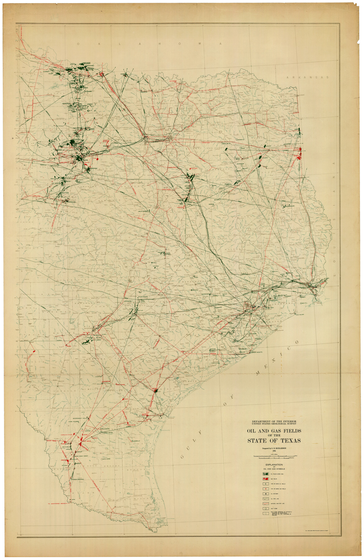
Oil and Gas Fields of the State of Texas
-
Map/Doc
89885
-
Collection
Twichell Survey Records
-
Object Dates
1931 (Creation Date)
-
People and Organizations
Department of the Interior (Publisher)
Lewis B. Pusey (Draftsman)
G.B. Richardson (Compiler)
-
Subjects
Energy Surface
-
Height x Width
38.4 x 59.2 inches
97.5 x 150.4 cm
Part of: Twichell Survey Records
[Sketch of most of Crosby County]
![89762, [Sketch of most of Crosby County], Twichell Survey Records](https://historictexasmaps.com/wmedia_w700/maps/89762-1.tif.jpg)
Print $40.00
- Digital $50.00
[Sketch of most of Crosby County]
Size 54.9 x 45.3 inches
Map/Doc 89762
Cochran County, Texas

Print $20.00
- Digital $50.00
Cochran County, Texas
1936
Size 37.8 x 43.7 inches
Map/Doc 89852

Hockley City Located on Labors 7, 8, 13, and 14 of Hood County School League Number 28 Situated in Hockley County, Texas

Print $20.00
- Digital $50.00
Hockley City Located on Labors 7, 8, 13, and 14 of Hood County School League Number 28 Situated in Hockley County, Texas
Size 24.2 x 30.8 inches
Map/Doc 92239
[Southeast part of County near Jas. H. Price Survey]
![91888, [Southeast part of County near Jas. H. Price Survey], Twichell Survey Records](https://historictexasmaps.com/wmedia_w700/maps/91888-1.tif.jpg)
Print $20.00
- Digital $50.00
[Southeast part of County near Jas. H. Price Survey]
Size 19.3 x 19.3 inches
Map/Doc 91888
Eberstadt and Brock's Subdivisions of the West Half of Survey 187 Block 2 A. B. & M., Randall County Texas

Print $20.00
- Digital $50.00
Eberstadt and Brock's Subdivisions of the West Half of Survey 187 Block 2 A. B. & M., Randall County Texas
Size 17.7 x 29.6 inches
Map/Doc 91748
Block 10, Deshazo, Borden County

Print $20.00
- Digital $50.00
Block 10, Deshazo, Borden County
Size 18.3 x 25.5 inches
Map/Doc 92127
Block 1 H&GN RR Co.

Print $20.00
- Digital $50.00
Block 1 H&GN RR Co.
Size 39.3 x 40.3 inches
Map/Doc 89769
Part of Roberts County, construction of survey lines copied from official map in use in General Land Office

Print $20.00
- Digital $50.00
Part of Roberts County, construction of survey lines copied from official map in use in General Land Office
1923
Size 12.7 x 19.3 inches
Map/Doc 91773
Western Cotton Oil Co. Property Lamb County, Texas

Print $20.00
- Digital $50.00
Western Cotton Oil Co. Property Lamb County, Texas
1951
Size 20.9 x 16.9 inches
Map/Doc 92166
[Capitol Leagues 661-729]
![92979, [Capitol Leagues 661-729], Twichell Survey Records](https://historictexasmaps.com/wmedia_w700/maps/92979-1.tif.jpg)
Print $20.00
- Digital $50.00
[Capitol Leagues 661-729]
Size 24.2 x 24.9 inches
Map/Doc 92979
Eleven County Map

Print $40.00
- Digital $50.00
Eleven County Map
Size 39.2 x 57.5 inches
Map/Doc 89856
You may also like
East Part of Brewster Co.

Print $40.00
- Digital $50.00
East Part of Brewster Co.
1952
Size 48.8 x 31.9 inches
Map/Doc 1785
Flight Mission No. DAG-14K, Frame 146, Matagorda County

Print $20.00
- Digital $50.00
Flight Mission No. DAG-14K, Frame 146, Matagorda County
1952
Size 18.4 x 22.2 inches
Map/Doc 86313
[T. C. RR. Co. Blocks 178, A1, G. C. & S. F. R. R. Co. Block C4, E. L. & R. R. RR C3]
![93214, [T. C. RR. Co. Blocks 178, A1, G. C. & S. F. R. R. Co. Block C4, E. L. & R. R. RR C3], Twichell Survey Records](https://historictexasmaps.com/wmedia_w700/maps/93214-1.tif.jpg)
Print $20.00
- Digital $50.00
[T. C. RR. Co. Blocks 178, A1, G. C. & S. F. R. R. Co. Block C4, E. L. & R. R. RR C3]
Size 40.1 x 28.7 inches
Map/Doc 93214
Survey for H.A. Wroe

Print $20.00
- Digital $50.00
Survey for H.A. Wroe
Size 19.6 x 10.4 inches
Map/Doc 601
Jefferson County Rolled Sketch 61D

Print $20.00
- Digital $50.00
Jefferson County Rolled Sketch 61D
Size 27.2 x 40.5 inches
Map/Doc 6413

Map of the World on Mercator's Projection, flags of all nations and cities of the United States

Print $40.00
- Digital $50.00
Map of the World on Mercator's Projection, flags of all nations and cities of the United States
1874
Size 40.4 x 55.6 inches
Map/Doc 93914
Lavaca County Working Sketch 24

Print $20.00
- Digital $50.00
Lavaca County Working Sketch 24
1985
Size 29.5 x 35.7 inches
Map/Doc 70377
[Surveys along State Line]
![91403, [Surveys along State Line], Twichell Survey Records](https://historictexasmaps.com/wmedia_w700/maps/91403-1.tif.jpg)
Print $3.00
- Digital $50.00
[Surveys along State Line]
Size 7.4 x 17.2 inches
Map/Doc 91403
Harrison County Working Sketch 31

Print $40.00
- Digital $50.00
Harrison County Working Sketch 31
2006
Size 48.0 x 50.2 inches
Map/Doc 87148
[Blocks 24, O, J, and L]
![92651, [Blocks 24, O, J, and L], Twichell Survey Records](https://historictexasmaps.com/wmedia_w700/maps/92651-1.tif.jpg)
Print $20.00
- Digital $50.00
[Blocks 24, O, J, and L]
Size 39.3 x 26.6 inches
Map/Doc 92651
The Mexican Department of Nacogdoches. May 6, 1833

Print $20.00
The Mexican Department of Nacogdoches. May 6, 1833
2020
Size 18.5 x 21.7 inches
Map/Doc 95973