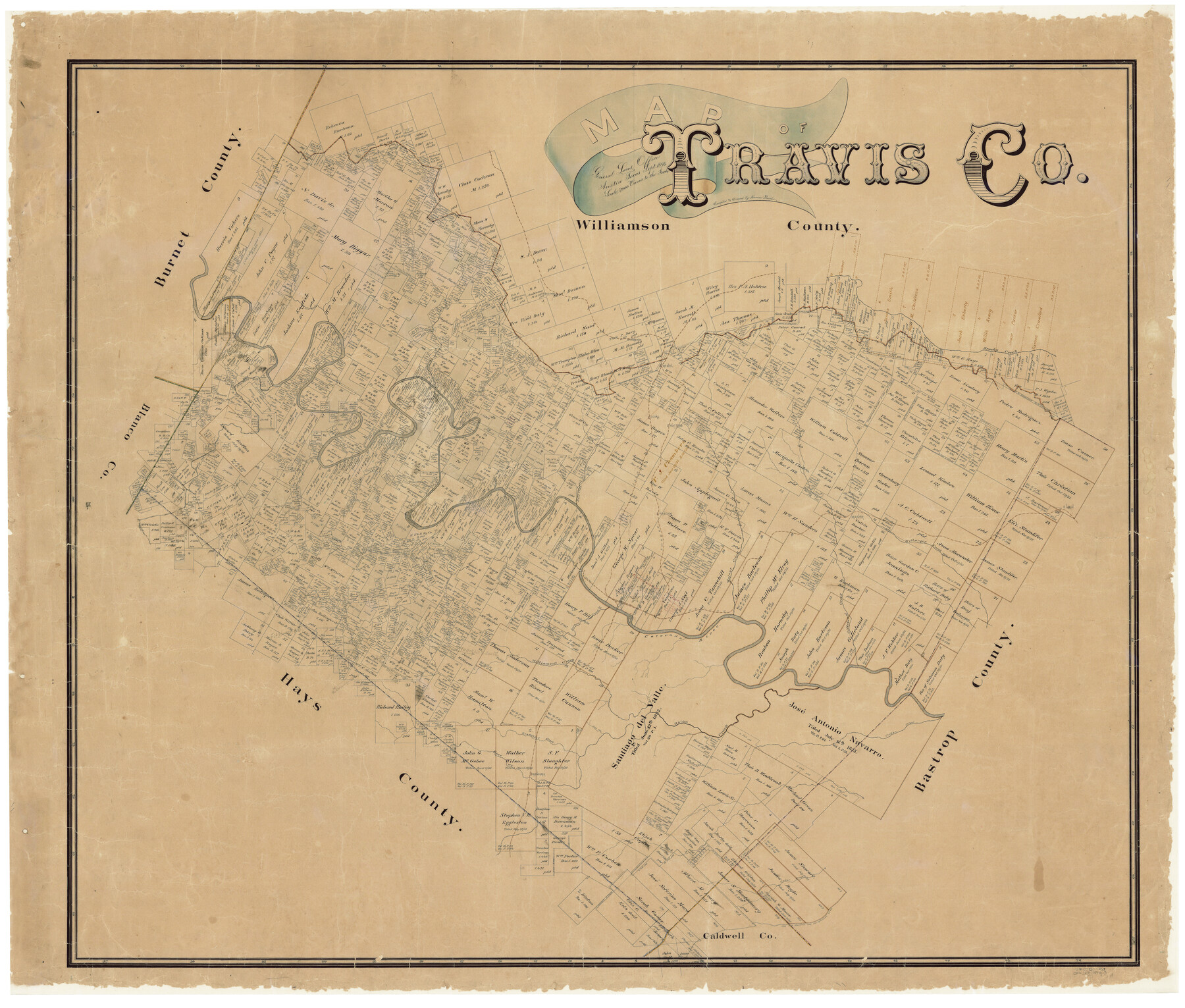
Map of Travis County
-
Map/Doc
16904
-
Collection
General Map Collection
-
Object Dates
9/1894 (Creation Date)
-
People and Organizations
Herman Pressler (Draftsman)
-
Counties
Travis
-
Subjects
County
-
Height x Width
49.8 x 58.8 inches
126.5 x 149.4 cm
-
Comments
Conservation funded in 2001 with donation from Frost Bank.
-
Features
A&NW
Brushy Creek
Nacogdoches Road
Old San Antonio Road
Bear Creek
Manchaca
Rock Spring Branch [of Onion Creek]
Cedar Creek
Cedar Valley Post Office
Cougar Branch [of Bull Creek]
H&TC
Cottonmouth Creek
Onion Creek
Boggy Creek
Slaughter Creek
Gilleland Creek
Williamson Creek
Barton Creek
Harrison Branch [of Colorado River]
Jolly Creek
Cat Hollow Creek
Cypress Creek
Basin Branch [of Pedernales River]
Clear Creek
I&GN
[Road] to Oak Hill and Austin
Oak Hill Road
Austin Road
[Road] to Hammett Crossing
[Road] to Dripping Springs
Grape Creek
Fitzhugh Post Office
Cedar Valley Post Office
McNeil
Linn Creek
Elgin
Hurst's Creek
Colorado River
Flat Creek
Turner's Branch [of Pedernales River]
Duval
Watters
Manor
Pedernales River
Red Bluff Creek
Deep Creek
Cummings
Cedar Park
Cow Creek
Cherry Hollow Creek
Bloody Hollow Creek
Hancock
Bull Creek
Devils Cañon
Turkey Creek
Dead Man's Hole Creek
Little Barton Creek
Nep's Branch [of Barton Creek]
Bee Creek
Dam Railroad
Shoal Creek
Austin
Walnut Creek
Wilbarger Creek
Rocky Creek
Long Branch [of Barton Creek]
-
URLs
https://medium.com/save-texas-history/map-of-travis-co-1894-by-herman-pressler-9fc6a25fd995#.fmh7tfkot
Part of: General Map Collection
Victoria County Working Sketch 7

Print $40.00
- Digital $50.00
Victoria County Working Sketch 7
1945
Size 55.3 x 18.0 inches
Map/Doc 72277
Bowie County Working Sketch 13

Print $20.00
- Digital $50.00
Bowie County Working Sketch 13
1959
Size 36.9 x 37.0 inches
Map/Doc 67417
Houston County Working Sketch 26

Print $20.00
- Digital $50.00
Houston County Working Sketch 26
1987
Size 30.1 x 20.4 inches
Map/Doc 66256
Loving County Rolled Sketch 8

Print $20.00
- Digital $50.00
Loving County Rolled Sketch 8
1975
Size 30.5 x 17.4 inches
Map/Doc 6639
Panola County Working Sketch 5

Print $20.00
- Digital $50.00
Panola County Working Sketch 5
1940
Map/Doc 71414
Henderson County Rolled Sketch 11

Print $20.00
- Digital $50.00
Henderson County Rolled Sketch 11
1915
Size 29.1 x 42.4 inches
Map/Doc 75948
Crosby County Rolled Sketch D

Print $20.00
- Digital $50.00
Crosby County Rolled Sketch D
Size 23.9 x 23.6 inches
Map/Doc 5643
Flight Mission No. CGI-3N, Frame 52, Cameron County

Print $20.00
- Digital $50.00
Flight Mission No. CGI-3N, Frame 52, Cameron County
1954
Size 18.7 x 22.2 inches
Map/Doc 84558
Flight Mission No. BQR-3K, Frame 83, Brazoria County

Print $20.00
- Digital $50.00
Flight Mission No. BQR-3K, Frame 83, Brazoria County
1952
Size 18.7 x 22.4 inches
Map/Doc 83975
Flight Mission No. DAG-21K, Frame 90, Matagorda County

Print $20.00
- Digital $50.00
Flight Mission No. DAG-21K, Frame 90, Matagorda County
1952
Size 18.5 x 22.2 inches
Map/Doc 86419
Lipscomb County

Print $20.00
- Digital $50.00
Lipscomb County
1932
Size 40.5 x 37.5 inches
Map/Doc 73222
Coleman County Working Sketch 19

Print $20.00
- Digital $50.00
Coleman County Working Sketch 19
1953
Size 18.1 x 15.4 inches
Map/Doc 68085
You may also like
Flight Mission No. BRA-16M, Frame 86, Jefferson County

Print $20.00
- Digital $50.00
Flight Mission No. BRA-16M, Frame 86, Jefferson County
1953
Size 18.5 x 22.3 inches
Map/Doc 85698
Kendall County Working Sketch 22

Print $20.00
- Digital $50.00
Kendall County Working Sketch 22
1971
Size 41.6 x 34.7 inches
Map/Doc 66694
Parker County Working Sketch 11

Print $20.00
- Digital $50.00
Parker County Working Sketch 11
1969
Map/Doc 71461
Harris County Sketch File 23a

Print $13.00
- Digital $50.00
Harris County Sketch File 23a
1839
Size 9.7 x 6.0 inches
Map/Doc 25379
G. C. & S. F., Main Line, Texas, Right of Way map, Rio Vista to Crowley

Print $40.00
- Digital $50.00
G. C. & S. F., Main Line, Texas, Right of Way map, Rio Vista to Crowley
1916
Size 40.2 x 92.0 inches
Map/Doc 64654
Clay County Sketch File 18

Print $4.00
- Digital $50.00
Clay County Sketch File 18
1875
Size 12.6 x 8.4 inches
Map/Doc 18427
Rusk County Sketch File 29

Print $8.00
Rusk County Sketch File 29
1949
Size 11.3 x 8.7 inches
Map/Doc 35554
[Sketch showing surveys in Sutton and Val Verde Counties, Texas]
![10779, [Sketch showing surveys in Sutton and Val Verde Counties, Texas], Maddox Collection](https://historictexasmaps.com/wmedia_w700/maps/10779.tif.jpg)
Print $20.00
- Digital $50.00
[Sketch showing surveys in Sutton and Val Verde Counties, Texas]
1880
Size 28.0 x 14.5 inches
Map/Doc 10779
Ward County Working Sketch 49

Print $40.00
- Digital $50.00
Ward County Working Sketch 49
1974
Size 54.8 x 37.1 inches
Map/Doc 72355
Goliad County Sketch File 36

Print $20.00
- Digital $50.00
Goliad County Sketch File 36
1925
Size 17.1 x 14.1 inches
Map/Doc 11571
Nueces County Sketch File 48

Print $20.00
- Digital $50.00
Nueces County Sketch File 48
1978
Size 14.1 x 8.5 inches
Map/Doc 32663
