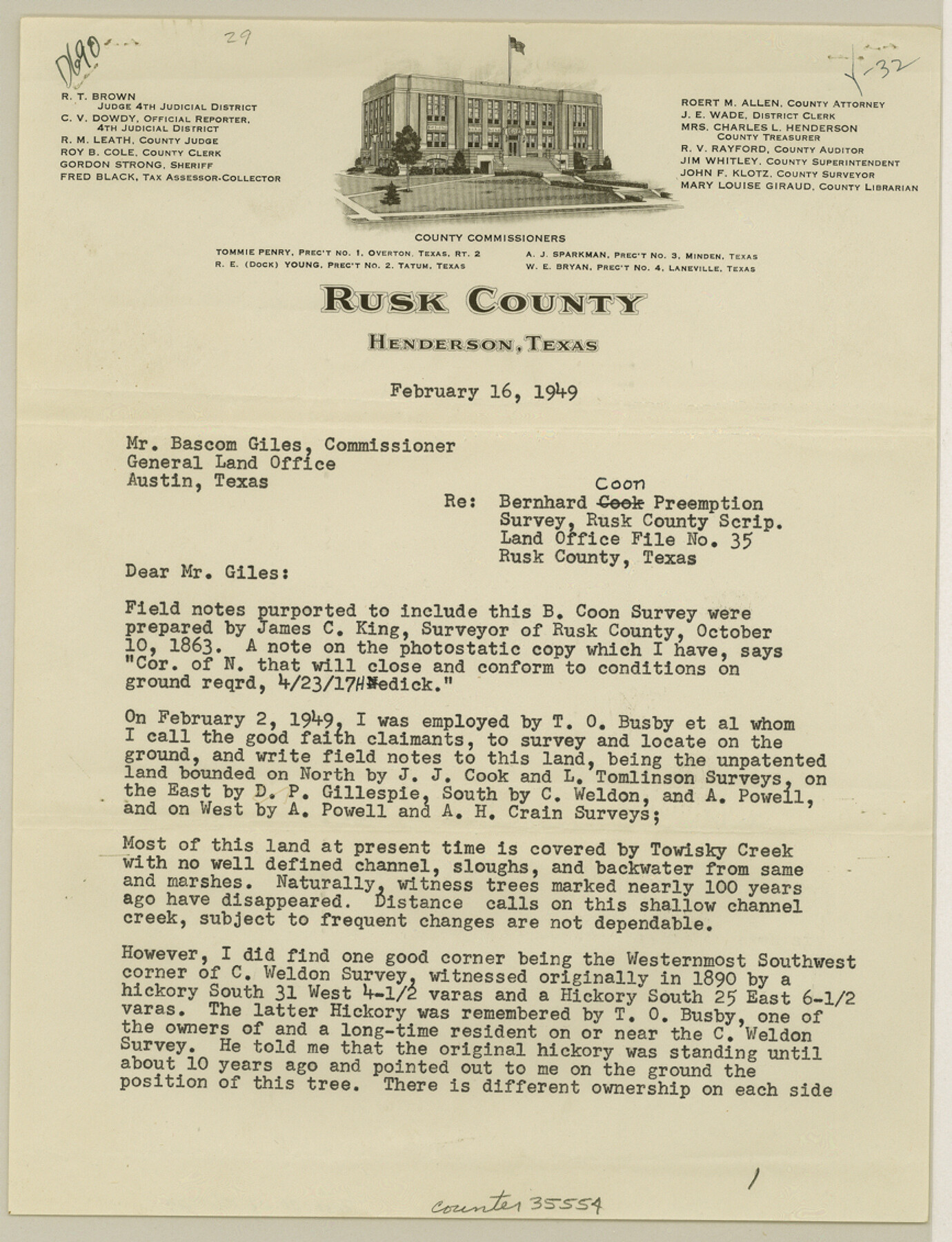
Rusk County Sketch File 29
[Surveyor's report of Bernhard Coon survey, north of Henderson]
-
Map/Doc
35554
-
Collection
General Map Collection
-
Object Dates
2/16/1949 (Creation Date)
4/6/1949 (File Date)
-
People and Organizations
John F. Klotz (Surveyor/Engineer)
-
Counties
Rusk
-
Subjects
Surveying Sketch File
-
Height x Width
11.3 x 8.7 inches
28.7 x 22.1 cm
-
Medium
paper, print
-
Features
Towisky Creek
Part of: General Map Collection
Amistad International Reservoir on Rio Grande 85

Print $20.00
- Digital $50.00
Amistad International Reservoir on Rio Grande 85
1949
Size 28.4 x 40.2 inches
Map/Doc 75514
Dickens County Working Sketch 5

Print $20.00
- Digital $50.00
Dickens County Working Sketch 5
1914
Size 30.6 x 20.8 inches
Map/Doc 68652
Runnels County Working Sketch 19

Print $20.00
- Digital $50.00
Runnels County Working Sketch 19
1950
Size 24.9 x 30.8 inches
Map/Doc 63615
Flight Mission No. BQR-9K, Frame 43, Brazoria County

Print $20.00
- Digital $50.00
Flight Mission No. BQR-9K, Frame 43, Brazoria County
1952
Size 18.6 x 22.3 inches
Map/Doc 84047
Flight Mission No. BRE-1P, Frame 143, Nueces County

Print $20.00
- Digital $50.00
Flight Mission No. BRE-1P, Frame 143, Nueces County
1956
Size 18.3 x 22.2 inches
Map/Doc 86703
Runnels County Sketch File 6

Print $5.00
Runnels County Sketch File 6
1872
Size 9.9 x 15.9 inches
Map/Doc 35440
Terrell County Sketch File 37

Print $4.00
- Digital $50.00
Terrell County Sketch File 37
Size 14.5 x 9.1 inches
Map/Doc 37999
Tom Green County Boundary File 87b

Print $4.00
- Digital $50.00
Tom Green County Boundary File 87b
Size 13.0 x 8.6 inches
Map/Doc 59401
Flight Mission No. DCL-6C, Frame 71, Kenedy County

Print $20.00
- Digital $50.00
Flight Mission No. DCL-6C, Frame 71, Kenedy County
1943
Size 18.6 x 22.3 inches
Map/Doc 85913
Burleson County Working Sketch 22

Print $20.00
- Digital $50.00
Burleson County Working Sketch 22
1980
Size 14.6 x 15.6 inches
Map/Doc 67741
Goliad County Working Sketch 1

Print $20.00
- Digital $50.00
Goliad County Working Sketch 1
Size 23.7 x 39.9 inches
Map/Doc 63191
Coleman County Working Sketch 24

Print $40.00
- Digital $50.00
Coleman County Working Sketch 24
1989
Size 43.1 x 54.3 inches
Map/Doc 68277
You may also like
[E. L. & R. R. RR. Blks. 9 & 10]
![90123, [E. L. & R. R. RR. Blks. 9 & 10], Twichell Survey Records](https://historictexasmaps.com/wmedia_w700/maps/90123-1.tif.jpg)
Print $2.00
- Digital $50.00
[E. L. & R. R. RR. Blks. 9 & 10]
Size 8.7 x 11.3 inches
Map/Doc 90123
Bandera County Sketch File 36

Print $6.00
- Digital $50.00
Bandera County Sketch File 36
Size 11.4 x 8.9 inches
Map/Doc 14034
Portion of Pecos County

Print $20.00
- Digital $50.00
Portion of Pecos County
Size 18.8 x 21.6 inches
Map/Doc 91589
Goliad County Rolled Sketch 2

Print $20.00
- Digital $50.00
Goliad County Rolled Sketch 2
1944
Size 33.1 x 34.6 inches
Map/Doc 9010
Atascosa County Rolled Sketch 8

Print $20.00
- Digital $50.00
Atascosa County Rolled Sketch 8
1942
Size 34.8 x 41.9 inches
Map/Doc 8427

[Beaumont, Sour Lake and Western Ry. Right of Way and Alignment - Frisco]
![64113, [Beaumont, Sour Lake and Western Ry. Right of Way and Alignment - Frisco], General Map Collection](https://historictexasmaps.com/wmedia_w700/maps/64113.tif.jpg)
Print $20.00
- Digital $50.00
[Beaumont, Sour Lake and Western Ry. Right of Way and Alignment - Frisco]
1910
Size 19.9 x 46.3 inches
Map/Doc 64113
J. W. Kendrick Land, Crosby County, Texas

Print $20.00
- Digital $50.00
J. W. Kendrick Land, Crosby County, Texas
Size 42.8 x 33.7 inches
Map/Doc 92603
Mills County Sketch File 14

Print $4.00
- Digital $50.00
Mills County Sketch File 14
1871
Size 6.8 x 8.0 inches
Map/Doc 31661
Flight Mission No. CRE-1R, Frame 134, Jackson County

Print $20.00
- Digital $50.00
Flight Mission No. CRE-1R, Frame 134, Jackson County
1956
Size 16.2 x 16.0 inches
Map/Doc 85342
Jim Hogg County Working Sketch 7

Print $20.00
- Digital $50.00
Jim Hogg County Working Sketch 7
1964
Size 20.0 x 18.6 inches
Map/Doc 66593
Concho County Working Sketch 12

Print $20.00
- Digital $50.00
Concho County Working Sketch 12
1951
Size 23.0 x 27.2 inches
Map/Doc 68194