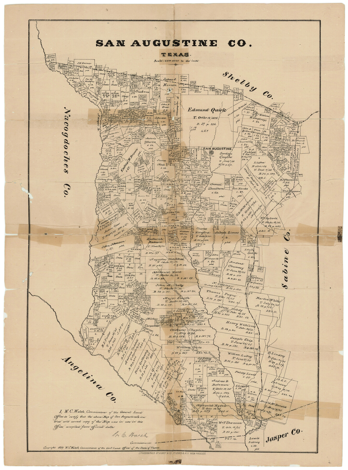
San Augustine County Texas
San Augustine County Sketch File 15
-
Map/Doc
4623
-
Collection
General Map Collection
-
Object Dates
1879 (Creation Date)
-
People and Organizations
W.C. Walsh (GLO Commissioner)
August Gast & Co. (Lithographer)
-
Counties
San Augustine
-
Subjects
County
-
Height x Width
23.8 x 16.9 inches
60.5 x 42.9 cm
-
Scale
1" = 4000 varas
-
Comments
"Lithographed by A. Gast & Co. St. Louis & N.Y. new process."
Part of: General Map Collection
Midland County Sketch File 14

Print $8.00
- Digital $50.00
Midland County Sketch File 14
1951
Size 10.9 x 8.7 inches
Map/Doc 31578
Presidio County Sketch File 88 1/2

Print $4.00
- Digital $50.00
Presidio County Sketch File 88 1/2
Size 14.4 x 8.8 inches
Map/Doc 34754
Runnels County Rolled Sketch 23

Print $20.00
- Digital $50.00
Runnels County Rolled Sketch 23
Size 21.8 x 27.0 inches
Map/Doc 7514
Donley County Sketch File 21

Print $4.00
- Digital $50.00
Donley County Sketch File 21
Size 8.4 x 9.5 inches
Map/Doc 21256
Dawson County Rolled Sketch 13

Print $20.00
- Digital $50.00
Dawson County Rolled Sketch 13
1951
Size 18.9 x 25.4 inches
Map/Doc 5696
Cherokee County Sketch File 20

Print $4.00
- Digital $50.00
Cherokee County Sketch File 20
1876
Size 8.2 x 6.0 inches
Map/Doc 18163
Bell County Sketch File 20

Print $4.00
- Digital $50.00
Bell County Sketch File 20
1855
Size 9.0 x 7.9 inches
Map/Doc 14406
Galveston County

Print $40.00
- Digital $50.00
Galveston County
1939
Size 44.0 x 55.5 inches
Map/Doc 73155
Ward County Rolled Sketch 24E

Print $40.00
- Digital $50.00
Ward County Rolled Sketch 24E
1967
Size 42.3 x 64.9 inches
Map/Doc 10116
Taylor County Sketch File 13

Print $8.00
- Digital $50.00
Taylor County Sketch File 13
1913
Size 9.1 x 8.5 inches
Map/Doc 37798
Kerr County Rolled Sketch 11

Print $20.00
- Digital $50.00
Kerr County Rolled Sketch 11
1950
Size 28.1 x 36.9 inches
Map/Doc 6495
Midland County Sketch File 9

Print $20.00
- Digital $50.00
Midland County Sketch File 9
Size 19.7 x 29.2 inches
Map/Doc 12085
You may also like
Coleman County Working Sketch 7

Print $20.00
- Digital $50.00
Coleman County Working Sketch 7
1942
Size 38.0 x 47.8 inches
Map/Doc 68073
Photostat of section of hydrographic surveys H-5399, H-4822, H-470

Print $20.00
- Digital $50.00
Photostat of section of hydrographic surveys H-5399, H-4822, H-470
1933
Size 18.4 x 25.8 inches
Map/Doc 61160
Idalou Lubbock County Texas Located on North 1/2 Sections 2 & 41 Block D7

Print $20.00
- Digital $50.00
Idalou Lubbock County Texas Located on North 1/2 Sections 2 & 41 Block D7
Size 30.0 x 16.4 inches
Map/Doc 92872
Cherokee County Sketch File 4

Print $7.00
- Digital $50.00
Cherokee County Sketch File 4
1850
Size 10.3 x 8.2 inches
Map/Doc 18117

Crane County Map of Unsurveyed School Lands for Bob Reid's Application to Lease

Print $40.00
- Digital $50.00
Crane County Map of Unsurveyed School Lands for Bob Reid's Application to Lease
1946
Size 49.0 x 51.3 inches
Map/Doc 90466

Atascosa County Working Sketch 38

Print $40.00
- Digital $50.00
Atascosa County Working Sketch 38
2011
Size 31.1 x 60.6 inches
Map/Doc 90031
Flight Mission No. BRE-1P, Frame 69, Nueces County

Print $20.00
- Digital $50.00
Flight Mission No. BRE-1P, Frame 69, Nueces County
1956
Size 18.3 x 22.1 inches
Map/Doc 86651
Flight Mission No. BRA-8M, Frame 85, Jefferson County

Print $20.00
- Digital $50.00
Flight Mission No. BRA-8M, Frame 85, Jefferson County
1953
Size 18.7 x 22.3 inches
Map/Doc 85605
Terrell County Working Sketch 64

Print $20.00
- Digital $50.00
Terrell County Working Sketch 64
1971
Size 29.3 x 27.7 inches
Map/Doc 69585
Intracoastal Waterway - Galveston Bay to West Bay including Galveston Bay Entrance

Print $20.00
- Digital $50.00
Intracoastal Waterway - Galveston Bay to West Bay including Galveston Bay Entrance
1961
Size 26.9 x 38.9 inches
Map/Doc 69935