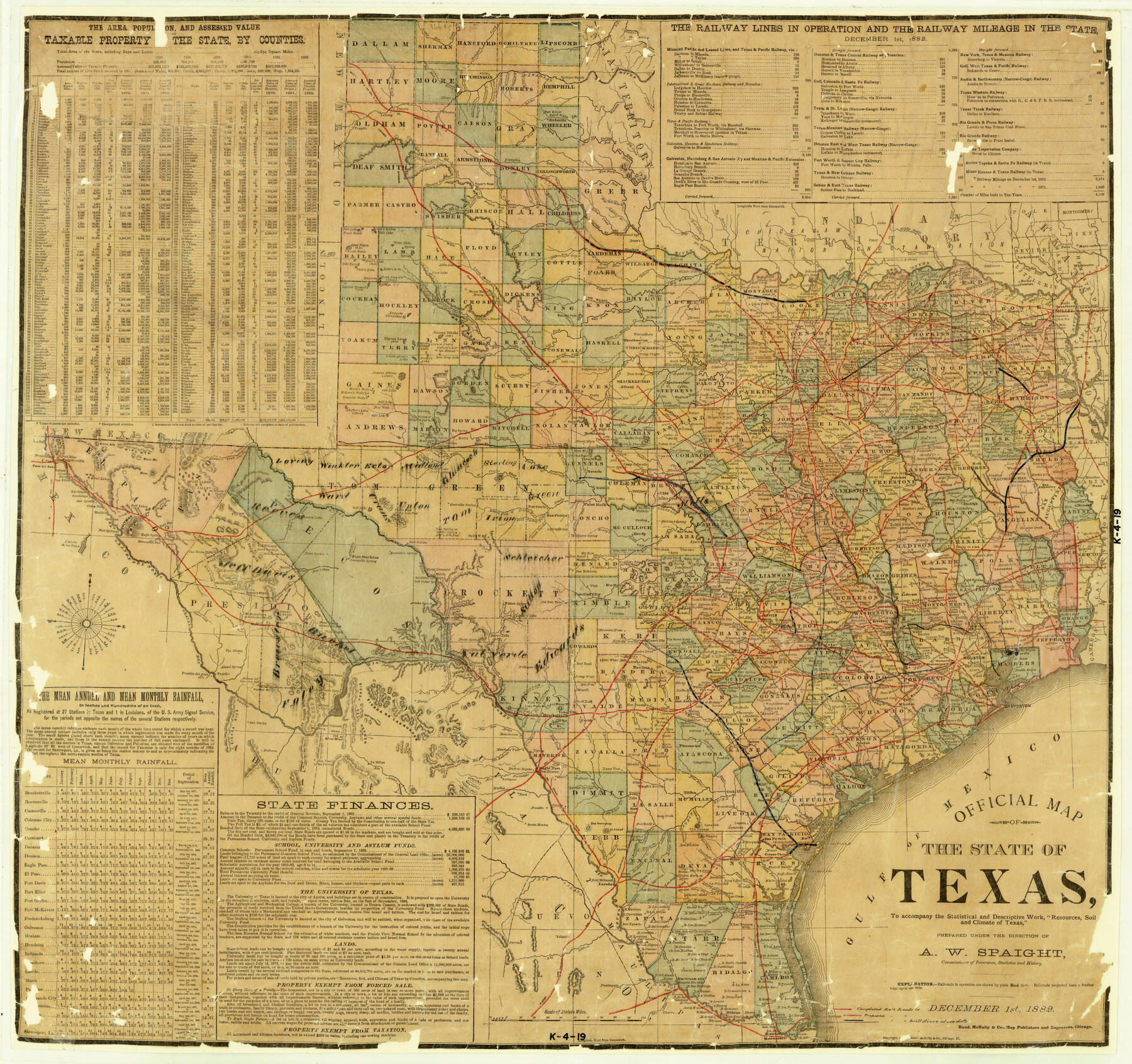
Official Map of the State of Texas to accompany the Statistical and Descriptive Work, "Resources, Soil and Climate of Texas"
K-4-19
-
Map/Doc
2134
-
Collection
General Map Collection
-
Object Dates
1882/12/1 (Creation Date)
-
People and Organizations
Rand, McNally and Co. (Publisher)
A.W. Spaight (Compiler)
-
Subjects
State of Texas
-
Height x Width
31.1 x 33.1 inches
79.0 x 84.1 cm
-
Comments
Insets: 1. State finance 2. Mean annual and monthly rainfall. 3. Railway lines in operation. 4. Taxable property.
Prepared to accompany "Resources, Soil and Climate of Texas".
Part of: General Map Collection
Ector County Working Sketch 30

Print $40.00
- Digital $50.00
Ector County Working Sketch 30
1971
Size 43.2 x 64.1 inches
Map/Doc 68873
Jefferson County Working Sketch 38

Print $20.00
- Digital $50.00
Jefferson County Working Sketch 38
1984
Size 32.6 x 43.2 inches
Map/Doc 66582
Harbor Pass and Bar at Brazos Santiago, Texas

Print $20.00
- Digital $50.00
Harbor Pass and Bar at Brazos Santiago, Texas
1879
Size 18.2 x 27.5 inches
Map/Doc 73000
San Jacinto County Working Sketch 7

Print $20.00
- Digital $50.00
San Jacinto County Working Sketch 7
1935
Size 32.0 x 41.4 inches
Map/Doc 63720
Hemphill County Sketch File 8

Print $9.00
- Digital $50.00
Hemphill County Sketch File 8
Size 14.3 x 8.9 inches
Map/Doc 26308
The Rand-McNally New Commercial Atlas Map of Texas

The Rand-McNally New Commercial Atlas Map of Texas
1914
Size 29.4 x 40.7 inches
Map/Doc 88745
Flight Mission No. DAH-9M, Frame 88, Orange County

Print $20.00
- Digital $50.00
Flight Mission No. DAH-9M, Frame 88, Orange County
1953
Size 18.5 x 22.6 inches
Map/Doc 86852
South Part Pecos County

Print $20.00
- Digital $50.00
South Part Pecos County
1976
Size 35.0 x 42.9 inches
Map/Doc 77393
Flight Mission No. BRE-2P, Frame 36, Nueces County

Print $20.00
- Digital $50.00
Flight Mission No. BRE-2P, Frame 36, Nueces County
1956
Size 18.5 x 22.7 inches
Map/Doc 86738
Hudspeth County Sketch File 21a

Print $10.00
- Digital $50.00
Hudspeth County Sketch File 21a
Size 10.6 x 8.4 inches
Map/Doc 26969
Val Verde County Sketch File AA3

Print $20.00
- Digital $50.00
Val Verde County Sketch File AA3
1924
Size 19.5 x 20.6 inches
Map/Doc 12540
Stephens County Sketch File 16

Print $40.00
- Digital $50.00
Stephens County Sketch File 16
Size 38.2 x 72.1 inches
Map/Doc 10608
You may also like
Hutchinson County Sketch File 6

Print $8.00
- Digital $50.00
Hutchinson County Sketch File 6
1890
Size 10.9 x 8.4 inches
Map/Doc 27198
Jim Hogg County Rolled Sketch 2

Print $20.00
- Digital $50.00
Jim Hogg County Rolled Sketch 2
Size 27.9 x 32.7 inches
Map/Doc 6438
Jeff Davis Co.

Print $20.00
- Digital $50.00
Jeff Davis Co.
1893
Size 27.4 x 47.9 inches
Map/Doc 66880
Travis County Working Sketch 8

Print $20.00
- Digital $50.00
Travis County Working Sketch 8
1917
Size 18.8 x 18.8 inches
Map/Doc 69392
Surveys on the Coleto Creek, Goliad County

Print $20.00
- Digital $50.00
Surveys on the Coleto Creek, Goliad County
1841
Size 13.8 x 14.9 inches
Map/Doc 10
Nueces County Sketch File 50

Print $463.00
- Digital $50.00
Nueces County Sketch File 50
Size 9.6 x 6.2 inches
Map/Doc 32673
Flight Mission No. BQR-7K, Frame 27, Brazoria County

Print $20.00
- Digital $50.00
Flight Mission No. BQR-7K, Frame 27, Brazoria County
1952
Size 18.6 x 22.3 inches
Map/Doc 84025
[Texas Gulf Coast from Rio Grande to Sabine Lake]
![72688, [Texas Gulf Coast from Rio Grande to Sabine Lake], General Map Collection](https://historictexasmaps.com/wmedia_w700/maps/72688.tif.jpg)
Print $20.00
- Digital $50.00
[Texas Gulf Coast from Rio Grande to Sabine Lake]
Size 27.8 x 18.3 inches
Map/Doc 72688
Map Showing Subdivision of Mallet Land and Cattle Company's Ranch Hockley and Cochran Counties, Texas

Print $20.00
- Digital $50.00
Map Showing Subdivision of Mallet Land and Cattle Company's Ranch Hockley and Cochran Counties, Texas
1924
Size 39.4 x 30.3 inches
Map/Doc 92210
Flight Mission No. DCL-7C, Frame 96, Kenedy County

Print $20.00
- Digital $50.00
Flight Mission No. DCL-7C, Frame 96, Kenedy County
1943
Size 15.4 x 15.2 inches
Map/Doc 86068
Smith's Atlas designed to accompany the Geography

Print $352.00
- Digital $50.00
Smith's Atlas designed to accompany the Geography
1850
Size 12.2 x 10.0 inches
Map/Doc 93881
Uvalde County Rolled Sketch 19

Print $20.00
- Digital $50.00
Uvalde County Rolled Sketch 19
Size 21.9 x 20.2 inches
Map/Doc 8103