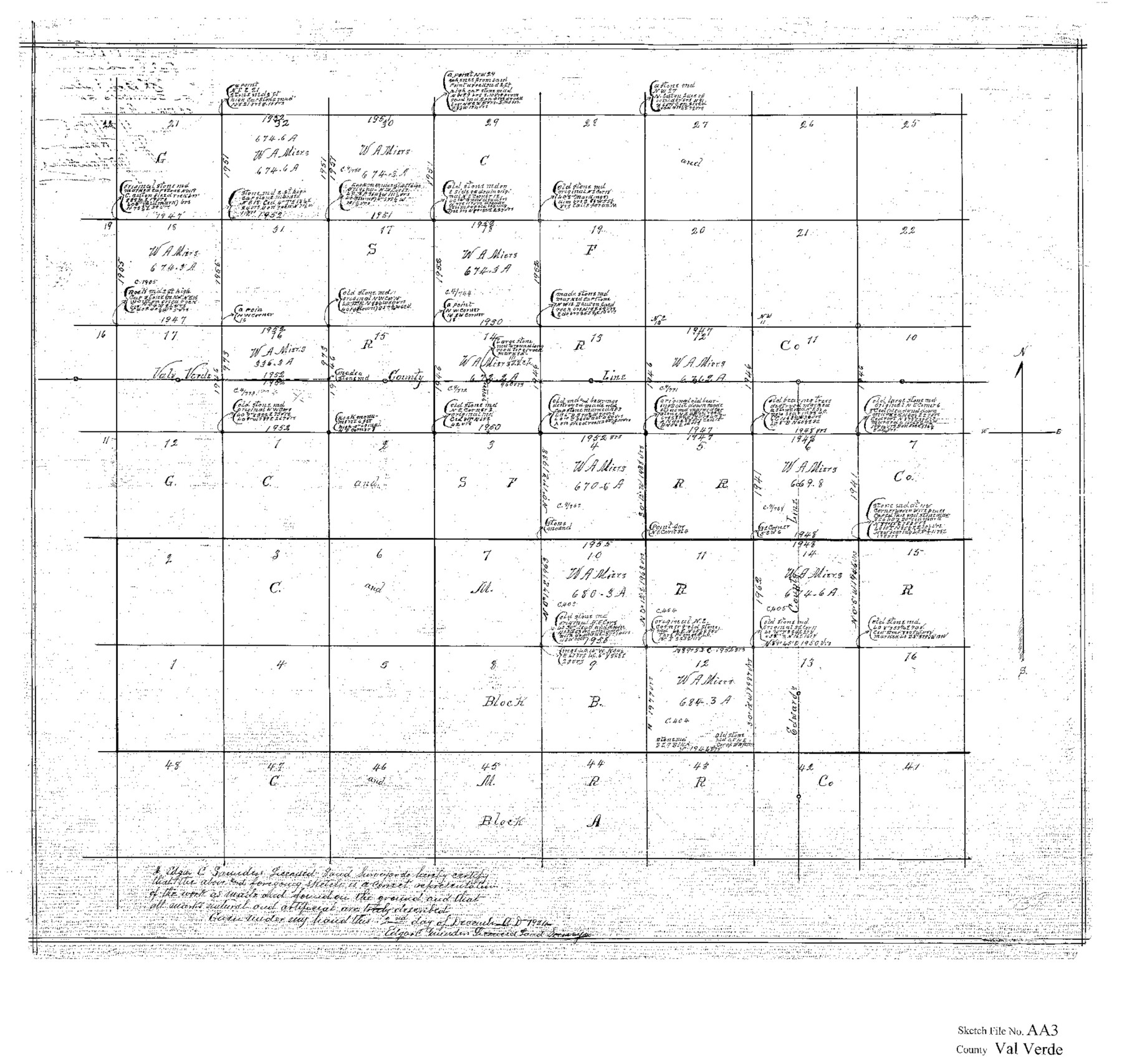
Val Verde County Sketch File AA3
[Sketch of parts of Blocks A and B in the northeast corner of the county]
-
Map/Doc
12540
-
Collection
General Map Collection
-
Object Dates
12/2/1924 (Creation Date)
1/21/1925 (File Date)
-
People and Organizations
Edgar C. Saunders (Surveyor/Engineer)
-
Counties
Val Verde Sutton Edwards
-
Subjects
Surveying Sketch File
-
Height x Width
19.5 x 20.6 inches
49.5 x 52.3 cm
-
Medium
paper, photocopy
Part of: General Map Collection
Schleicher County Sketch File 19

Print $6.00
- Digital $50.00
Schleicher County Sketch File 19
1932
Size 11.5 x 15.1 inches
Map/Doc 36508
United States - Gulf Coast - From Latitude 26° 33' to the Rio Grande Texas

Print $20.00
- Digital $50.00
United States - Gulf Coast - From Latitude 26° 33' to the Rio Grande Texas
1919
Size 27.2 x 18.4 inches
Map/Doc 72856
Refugio County Sketch File 5

Print $8.00
- Digital $50.00
Refugio County Sketch File 5
1849
Size 12.8 x 8.3 inches
Map/Doc 35245
Flight Mission No. DCL-4C, Frame 120, Kenedy County

Print $20.00
- Digital $50.00
Flight Mission No. DCL-4C, Frame 120, Kenedy County
1943
Size 18.6 x 22.5 inches
Map/Doc 85819
Blanco County Working Sketch 15

Print $20.00
- Digital $50.00
Blanco County Working Sketch 15
1950
Size 23.5 x 20.7 inches
Map/Doc 67375
Wilson County Sketch File 4

Print $28.00
- Digital $50.00
Wilson County Sketch File 4
1851
Size 8.4 x 7.7 inches
Map/Doc 40404
Foard County Aerial Photograph Index Sheet 3

Print $20.00
- Digital $50.00
Foard County Aerial Photograph Index Sheet 3
1950
Size 20.3 x 18.9 inches
Map/Doc 83690
Map of Potter County

Print $20.00
- Digital $50.00
Map of Potter County
1895
Size 27.0 x 21.1 inches
Map/Doc 3966
Glasscock County Sketch File 18

Print $8.00
- Digital $50.00
Glasscock County Sketch File 18
1931
Size 9.7 x 6.2 inches
Map/Doc 24192
Cass County Rolled Sketch OPD

Print $20.00
- Digital $50.00
Cass County Rolled Sketch OPD
1936
Size 29.6 x 24.9 inches
Map/Doc 5415
Parker County Sketch File 29

Print $20.00
- Digital $50.00
Parker County Sketch File 29
1876
Size 10.1 x 19.7 inches
Map/Doc 12147
Webb County Working Sketch 77

Print $20.00
- Digital $50.00
Webb County Working Sketch 77
1976
Size 25.8 x 26.1 inches
Map/Doc 72444
You may also like
Fort Bend County Sketch File 32

Print $6.00
- Digital $50.00
Fort Bend County Sketch File 32
1957
Size 14.2 x 8.7 inches
Map/Doc 23002
Reeves County Working Sketch 54

Print $20.00
- Digital $50.00
Reeves County Working Sketch 54
1978
Size 36.9 x 35.6 inches
Map/Doc 63497
[Sketch showing G. H.& H. Ry. Co. Blks. 2 and 3, H. & T. C. Ry. Co. Blk. 45 and T. &N. O. Ry. Co. Blk. 5T]
![89679, [Sketch showing G. H.& H. Ry. Co. Blks. 2 and 3, H. & T. C. Ry. Co. Blk. 45 and T. &N. O. Ry. Co. Blk. 5T], Twichell Survey Records](https://historictexasmaps.com/wmedia_w700/maps/89679-1.tif.jpg)
Print $20.00
- Digital $50.00
[Sketch showing G. H.& H. Ry. Co. Blks. 2 and 3, H. & T. C. Ry. Co. Blk. 45 and T. &N. O. Ry. Co. Blk. 5T]
1890
Size 23.6 x 36.8 inches
Map/Doc 89679
Erath County Working Sketch 50b

Print $20.00
- Digital $50.00
Erath County Working Sketch 50b
Size 43.4 x 25.8 inches
Map/Doc 69132
Wilbarger County Working Sketch 16

Print $20.00
- Digital $50.00
Wilbarger County Working Sketch 16
1955
Size 32.7 x 19.9 inches
Map/Doc 72554
[Blocks C-3, A-2, 29, GG and I]
![91612, [Blocks C-3, A-2, 29, GG and I], Twichell Survey Records](https://historictexasmaps.com/wmedia_w700/maps/91612-1.tif.jpg)
Print $20.00
- Digital $50.00
[Blocks C-3, A-2, 29, GG and I]
Size 26.0 x 18.8 inches
Map/Doc 91612
Marion County Working Sketch 41

Print $40.00
- Digital $50.00
Marion County Working Sketch 41
1996
Size 34.0 x 48.5 inches
Map/Doc 70817
Brewster County Sketch File NS-9

Print $40.00
- Digital $50.00
Brewster County Sketch File NS-9
1944
Size 14.2 x 8.9 inches
Map/Doc 16135
Cottle County Sketch File 3a

Print $14.00
- Digital $50.00
Cottle County Sketch File 3a
Size 12.9 x 8.8 inches
Map/Doc 19459
Wise County Sketch File 2a

Print $4.00
- Digital $50.00
Wise County Sketch File 2a
1856
Size 12.3 x 8.1 inches
Map/Doc 40526
Lee County Working Sketch 21

Print $40.00
- Digital $50.00
Lee County Working Sketch 21
2009
Size 48.7 x 36.6 inches
Map/Doc 89258
El Paso County Rolled Sketch 64

Print $246.00
- Digital $50.00
El Paso County Rolled Sketch 64
1993
Size 11.3 x 8.7 inches
Map/Doc 41531