Brewster County Sketch File NS-9
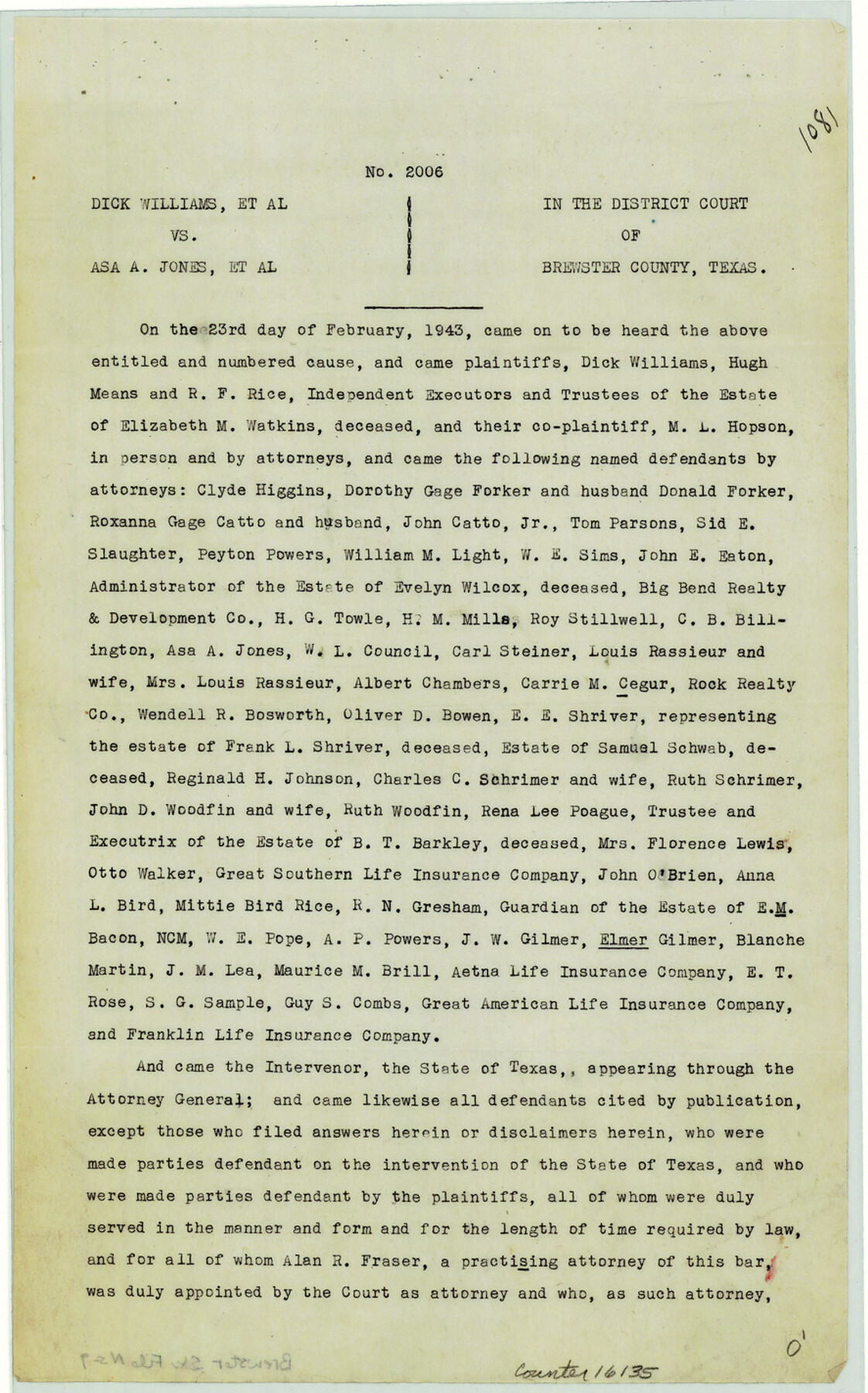
[District Court of Brewster County Cause No. 2006, Dick Williams, et al. vs. Asa A. Jones, et al. and Mandate, Court of Civil Appeals, 8th Judicial District , El Paso, Texas]
-
Map/Doc
16135
-
Collection
General Map Collection
-
Object Dates
1944/11/28 (Creation Date)
1945/1/12 (Creation Date)
1947/10/16 (File Date)
-
Counties
Brewster
-
Subjects
Surveying Sketch File
-
Height x Width
14.2 x 8.9 inches
36.1 x 22.6 cm
-
Medium
paper, print
-
Features
Bullis Mountain
Maravillas Creek
Part of: General Map Collection
Flight Mission No. CGI-3N, Frame 129, Cameron County

Print $20.00
- Digital $50.00
Flight Mission No. CGI-3N, Frame 129, Cameron County
1954
Size 18.5 x 22.2 inches
Map/Doc 84602
Colorado County Working Sketch 11

Print $3.00
- Digital $50.00
Colorado County Working Sketch 11
1942
Size 10.6 x 16.5 inches
Map/Doc 68111
Van Zandt County Sketch File 25

Print $4.00
- Digital $50.00
Van Zandt County Sketch File 25
Size 7.6 x 8.8 inches
Map/Doc 39443
Andrews County Rolled Sketch 17

Print $40.00
- Digital $50.00
Andrews County Rolled Sketch 17
1934
Size 30.9 x 48.9 inches
Map/Doc 8393
Jasper County Sketch File 20

Print $4.00
- Digital $50.00
Jasper County Sketch File 20
Size 8.7 x 12.2 inches
Map/Doc 27818
Red River County Sketch File 5a

Print $2.00
- Digital $50.00
Red River County Sketch File 5a
Size 4.7 x 6.6 inches
Map/Doc 35104
Washington County Texas

Print $20.00
- Digital $50.00
Washington County Texas
1879
Size 13.2 x 21.3 inches
Map/Doc 4124
McCulloch County Rolled Sketch 11

Print $20.00
- Digital $50.00
McCulloch County Rolled Sketch 11
1992
Size 46.3 x 40.3 inches
Map/Doc 9499
Travis County Sketch File 4

Print $9.00
- Digital $50.00
Travis County Sketch File 4
1853
Size 13.1 x 8.2 inches
Map/Doc 38275
Brooks County

Print $20.00
- Digital $50.00
Brooks County
1955
Size 40.3 x 32.2 inches
Map/Doc 77223
Station Map, the Missouri, Kansas and Texas Ry. Of Texas - Henrietta Division

Print $20.00
- Digital $50.00
Station Map, the Missouri, Kansas and Texas Ry. Of Texas - Henrietta Division
1918
Size 11.7 x 26.8 inches
Map/Doc 64764
Nueces County Rolled Sketch 28

Print $20.00
- Digital $50.00
Nueces County Rolled Sketch 28
Size 16.8 x 25.1 inches
Map/Doc 6874
You may also like
Bexar County Rolled Sketch 4A

Print $20.00
- Digital $50.00
Bexar County Rolled Sketch 4A
1982
Size 24.4 x 36.7 inches
Map/Doc 5138
Haskell County Sketch File 6

Print $22.00
- Digital $50.00
Haskell County Sketch File 6
1858
Size 7.7 x 12.2 inches
Map/Doc 26126
Edwards County Rolled Sketch J

Print $83.00
- Digital $50.00
Edwards County Rolled Sketch J
1918
Size 23.6 x 30.3 inches
Map/Doc 5818
El Paso County Rolled Sketch 10

Print $93.00
- Digital $50.00
El Paso County Rolled Sketch 10
1883
Size 42.4 x 61.3 inches
Map/Doc 8853

General Highway Map, McMullen County, Texas

Print $20.00
General Highway Map, McMullen County, Texas
1940
Size 24.6 x 18.5 inches
Map/Doc 79193
Flight Mission No. CGI-4N, Frame 178, Cameron County

Print $20.00
- Digital $50.00
Flight Mission No. CGI-4N, Frame 178, Cameron County
1955
Size 18.6 x 22.3 inches
Map/Doc 84681
Knox County Boundary File 1a

Print $16.00
- Digital $50.00
Knox County Boundary File 1a
Size 9.7 x 13.8 inches
Map/Doc 65010
Webb County Rolled Sketch 11

Print $20.00
- Digital $50.00
Webb County Rolled Sketch 11
1911
Size 37.1 x 34.7 inches
Map/Doc 10118
Brewster County Sketch File 50

Print $32.00
- Digital $50.00
Brewster County Sketch File 50
1995
Size 14.8 x 8.5 inches
Map/Doc 16336
Deaf Smith County, Texas / [Sec. 144, Blk. K-5]
![90623, Deaf Smith County, Texas / [Sec. 144, Blk. K-5], Twichell Survey Records](https://historictexasmaps.com/wmedia_w700/maps/90623-1.tif.jpg)
Print $20.00
- Digital $50.00
Deaf Smith County, Texas / [Sec. 144, Blk. K-5]
Size 22.9 x 22.8 inches
Map/Doc 90623
Atascosa County Sketch File 27a

Print $4.00
- Digital $50.00
Atascosa County Sketch File 27a
Size 8.4 x 14.3 inches
Map/Doc 13799