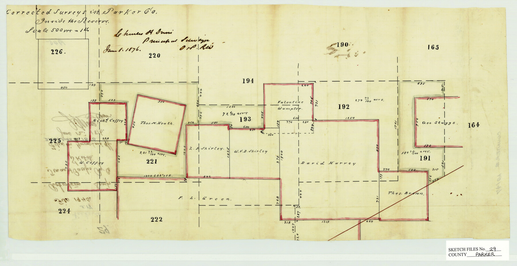
Parker County Sketch File 29
Corrected Surveys Inside the [T.&P. RR. Co.] Reserve, Parker County, Texas
-
Map/Doc
12147
-
Collection
General Map Collection
-
Object Dates
6/8/1876 (Creation Date)
6/12/1876 (File Date)
-
People and Organizations
Charles H. Irvin (Surveyor/Engineer)
-
Counties
Parker
-
Subjects
Surveying Sketch File
-
Height x Width
10.1 x 19.7 inches
25.7 x 50.0 cm
-
Medium
paper, manuscript
-
Scale
1" = 500 varas
Part of: General Map Collection
Hudspeth County Sketch File 24

Print $20.00
- Digital $50.00
Hudspeth County Sketch File 24
1936
Size 17.8 x 16.7 inches
Map/Doc 11802
San Jacinto County Sketch File 14

Print $20.00
San Jacinto County Sketch File 14
Size 15.8 x 18.2 inches
Map/Doc 12281
Montgomery County Sketch File 9

Print $6.00
- Digital $50.00
Montgomery County Sketch File 9
Size 9.0 x 7.6 inches
Map/Doc 31795
Colorado County Sketch File 24

Print $20.00
- Digital $50.00
Colorado County Sketch File 24
Size 22.7 x 16.6 inches
Map/Doc 11137
Nueces County Aerial Photograph Index Sheet 5

Print $20.00
- Digital $50.00
Nueces County Aerial Photograph Index Sheet 5
1956
Size 19.5 x 23.4 inches
Map/Doc 83738
Kimble County Rolled Sketch 17 1/2

Print $59.00
- Digital $50.00
Kimble County Rolled Sketch 17 1/2
1889
Size 27.0 x 38.3 inches
Map/Doc 6510
Hudspeth County Sketch File 36

Print $12.00
- Digital $50.00
Hudspeth County Sketch File 36
1901
Size 10.5 x 8.2 inches
Map/Doc 27003
San Augustine County Sketch File 6

Print $4.00
San Augustine County Sketch File 6
1858
Size 6.4 x 7.7 inches
Map/Doc 35644
Brewster County Sketch File N-12

Print $4.00
- Digital $50.00
Brewster County Sketch File N-12
1933
Size 14.3 x 9.0 inches
Map/Doc 15623
Hill County Boundary File 45

Print $41.00
- Digital $50.00
Hill County Boundary File 45
Size 9.0 x 3.6 inches
Map/Doc 54743
Map of Galveston, Turtle & East Bays & portions of the Gulf of Mexico in Chambers & Galveston Counties, Texas showing subdivision for mineral development

Print $40.00
- Digital $50.00
Map of Galveston, Turtle & East Bays & portions of the Gulf of Mexico in Chambers & Galveston Counties, Texas showing subdivision for mineral development
1949
Size 48.9 x 54.8 inches
Map/Doc 2977
Controlled Mosaic by Jack Amman Photogrammetric Engineers, Inc - Sheet 4

Print $20.00
- Digital $50.00
Controlled Mosaic by Jack Amman Photogrammetric Engineers, Inc - Sheet 4
1954
Size 20.0 x 24.0 inches
Map/Doc 83448
You may also like

Sutton County

Print $40.00
- Digital $50.00
Sutton County
1941
Size 43.9 x 56.1 inches
Map/Doc 73296
Working Sketch Crockett County

Print $20.00
- Digital $50.00
Working Sketch Crockett County
1925
Size 16.6 x 15.2 inches
Map/Doc 90476
Hardin County Sketch File 10

Print $4.00
- Digital $50.00
Hardin County Sketch File 10
1862
Size 12.5 x 8.0 inches
Map/Doc 25110
Calhoun County NRC Article 33.136 Sketch 8

Print $28.00
- Digital $50.00
Calhoun County NRC Article 33.136 Sketch 8
2019
Size 17.9 x 23.8 inches
Map/Doc 95371
Presidio County Rolled Sketch 131A

Print $20.00
- Digital $50.00
Presidio County Rolled Sketch 131A
Size 17.7 x 11.9 inches
Map/Doc 10710
Tahoka Heights Addition to Tahoka Located on the SE Quarter of Section 568

Print $20.00
- Digital $50.00
Tahoka Heights Addition to Tahoka Located on the SE Quarter of Section 568
Size 18.1 x 18.5 inches
Map/Doc 92939
Kimble County Working Sketch 26

Print $20.00
- Digital $50.00
Kimble County Working Sketch 26
1934
Size 24.3 x 18.4 inches
Map/Doc 70094
Cherokee County Working Sketch 4

Print $20.00
- Digital $50.00
Cherokee County Working Sketch 4
1950
Size 33.1 x 31.5 inches
Map/Doc 67959
Houston County Sketch File 1a

Print $4.00
- Digital $50.00
Houston County Sketch File 1a
Size 9.2 x 7.8 inches
Map/Doc 26742
Martin County, Texas

Print $20.00
- Digital $50.00
Martin County, Texas
1870
Size 22.9 x 18.0 inches
Map/Doc 391
Right of Way and Track Map, Galveston, Harrisburg & San Antonio Ry. operated by the T. & N. O. R.R. Co., Victoria Division, Rosenberg to Beeville

Print $40.00
- Digital $50.00
Right of Way and Track Map, Galveston, Harrisburg & San Antonio Ry. operated by the T. & N. O. R.R. Co., Victoria Division, Rosenberg to Beeville
1918
Size 24.8 x 56.4 inches
Map/Doc 76164