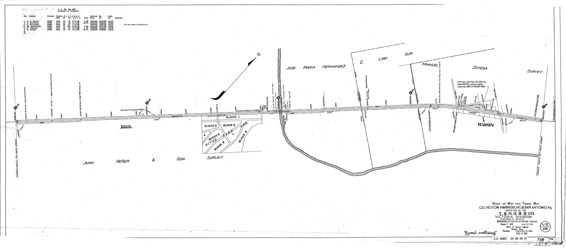
Right of Way and Track Map, Galveston, Harrisburg & San Antonio Ry. operated by the T. & N. O. R.R. Co., Victoria Division, Rosenberg to Beeville
Station 5227+20 to Station 5438+40
Z-2-207
-
Map/Doc
76164
-
Collection
General Map Collection
-
Object Dates
1918/6/30 (Creation Date)
1927/12/31 (Revision Date)
1930/12/31 (Revision Date)
-
People and Organizations
Office of Special Engineer (Publisher)
Phillip Szurgot (Donor)
-
Counties
Victoria
-
Subjects
Railroads
-
Height x Width
24.8 x 56.4 inches
63.0 x 143.3 cm
-
Medium
paper, photocopy
-
Scale
1" = 400'
-
Comments
Donated by Phillip Szurgot of CDS/Muery Services, San Antonio, June 28, 2002.
See 76157 through 76164 for all segments. -
Features
GH&SA
T&NO
Raisin
Coleto River
Part of: General Map Collection
Red River County Working Sketch 13

Print $20.00
- Digital $50.00
Red River County Working Sketch 13
1947
Size 37.1 x 39.9 inches
Map/Doc 71996
America's Fun-Tier: Texas 1967 Official State Highway Map

Digital $50.00
America's Fun-Tier: Texas 1967 Official State Highway Map
Size 28.3 x 36.6 inches
Map/Doc 94322
Cooke County Working Sketch 7

Print $20.00
- Digital $50.00
Cooke County Working Sketch 7
1939
Size 25.1 x 33.7 inches
Map/Doc 68244
Flight Mission No. CRC-3R, Frame 9, Chambers County

Print $20.00
- Digital $50.00
Flight Mission No. CRC-3R, Frame 9, Chambers County
1956
Size 18.7 x 22.4 inches
Map/Doc 84783
Clarkson's City Map of Port Aransas

Print $20.00
- Digital $50.00
Clarkson's City Map of Port Aransas
Size 18.5 x 26.5 inches
Map/Doc 3040
Taylor County

Print $20.00
- Digital $50.00
Taylor County
1934
Size 42.0 x 36.6 inches
Map/Doc 77432
[Edwards Co.]
![66811, [Edwards Co.], General Map Collection](https://historictexasmaps.com/wmedia_w700/maps/66811.tif.jpg)
Print $20.00
- Digital $50.00
[Edwards Co.]
1910
Size 38.8 x 36.2 inches
Map/Doc 66811
Kendall County Working Sketch 6

Print $20.00
- Digital $50.00
Kendall County Working Sketch 6
1947
Size 42.6 x 24.8 inches
Map/Doc 66678
Presidio County Working Sketch 80

Print $20.00
- Digital $50.00
Presidio County Working Sketch 80
1967
Size 18.8 x 30.5 inches
Map/Doc 71757
Victoria County Working Sketch 5

Print $20.00
- Digital $50.00
Victoria County Working Sketch 5
1944
Size 35.2 x 40.8 inches
Map/Doc 72275
Hardin County Rolled Sketch 22

Print $20.00
- Digital $50.00
Hardin County Rolled Sketch 22
1977
Size 32.0 x 44.4 inches
Map/Doc 9110
[Corpus Christi Bay, Padre Island, Mustang Island, Laguna de la Madre, King and Kenedy's Pasture]
![73046, [Corpus Christi Bay, Padre Island, Mustang Island, Laguna de la Madre, King and Kenedy's Pasture], General Map Collection](https://historictexasmaps.com/wmedia_w700/maps/73046.tif.jpg)
Print $20.00
- Digital $50.00
[Corpus Christi Bay, Padre Island, Mustang Island, Laguna de la Madre, King and Kenedy's Pasture]
Size 26.4 x 18.2 inches
Map/Doc 73046
You may also like
Sketch Showing Division Fence Shelton- Matador, Oldham County, Texas

Print $20.00
- Digital $50.00
Sketch Showing Division Fence Shelton- Matador, Oldham County, Texas
Size 21.2 x 23.0 inches
Map/Doc 91427
Harbor Pass and Bar at Brazos Santiago, Texas

Print $20.00
- Digital $50.00
Harbor Pass and Bar at Brazos Santiago, Texas
1879
Size 18.2 x 27.5 inches
Map/Doc 73000
Colorado County Sketch File 8

Print $4.00
- Digital $50.00
Colorado County Sketch File 8
1861
Size 12.4 x 8.5 inches
Map/Doc 18927

The Republic County of Brazoria. Proposed, Late Fall 1837-January 1, 1838

Print $20.00
The Republic County of Brazoria. Proposed, Late Fall 1837-January 1, 1838
2020
Size 13.0 x 21.7 inches
Map/Doc 96110
Jim Wells County Working Sketch 9

Print $20.00
- Digital $50.00
Jim Wells County Working Sketch 9
1948
Size 34.1 x 38.9 inches
Map/Doc 66607
Pecos County Sketch File 41

Print $32.00
- Digital $50.00
Pecos County Sketch File 41
1919
Size 11.2 x 8.8 inches
Map/Doc 33729
Pecos County Rolled Sketch 181

Print $20.00
- Digital $50.00
Pecos County Rolled Sketch 181
1980
Size 18.4 x 18.7 inches
Map/Doc 7300
Working Sketch in SW cor. of Coleman Co. showing the excess in the surveys fronting on the river and the relative position of surveys north of them according to latest data on file in the Genl. Land Office

Print $20.00
- Digital $50.00
Working Sketch in SW cor. of Coleman Co. showing the excess in the surveys fronting on the river and the relative position of surveys north of them according to latest data on file in the Genl. Land Office
1892
Size 18.8 x 14.1 inches
Map/Doc 441
Marion County Rolled Sketch 1A

Print $15.00
- Digital $50.00
Marion County Rolled Sketch 1A
1954
Size 9.9 x 15.2 inches
Map/Doc 46610
Map illustrating the general geological features of the country west of the Mississippi River compiled from the surveys of W.H. Emory and from the Pacific Railroad surveys & other sources

Print $20.00
- Digital $50.00
Map illustrating the general geological features of the country west of the Mississippi River compiled from the surveys of W.H. Emory and from the Pacific Railroad surveys & other sources
1857
Size 21.2 x 24.7 inches
Map/Doc 95172
Flight Mission No. DAG-24K, Frame 135, Matagorda County

Print $20.00
- Digital $50.00
Flight Mission No. DAG-24K, Frame 135, Matagorda County
1953
Size 18.4 x 22.2 inches
Map/Doc 86553