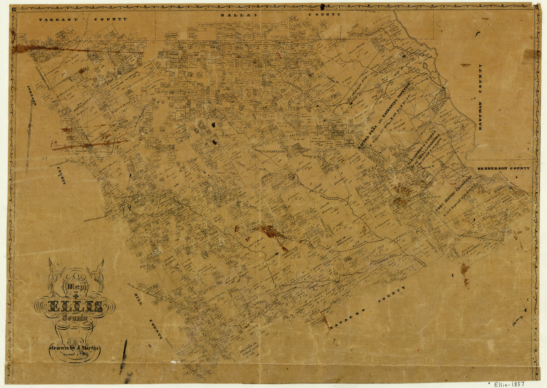
Map of Ellis County
-
Map/Doc
3510
-
Collection
General Map Collection
-
Object Dates
11/1/1857 (Creation Date)
-
People and Organizations
Joseph Martin (Draftsman)
-
Counties
Ellis
-
Subjects
County
-
Height x Width
20.2 x 28.1 inches
51.3 x 71.4 cm
-
Features
Bee Creek
Middle Fork of Mountain Creek
North Fork of Chambers Creek
South Fork of Chambers Creek
Chambers Creek
Village Creek
Trinity River
Cummings [sic] Creek
Onion Creek
Waxahatchie [sic]
Mill Creek
North Fork of Richland Creek
Richland Creek
Pecan Creek
Buck Creek
Hog Creek
Rock Creek
Mustang Creek
Waxahachi [sic] Creek
South Fork of Waxahachi [sic] Creek
North Fork of Waxahachi [sic] Creek
Grove Creek
Bullock Creek
Red Oak Creek
Smith Creek
Pleasant Run
Bois D'Arc Lake
Bois de Arch [sic] Creek
Sublets Creek
Cedar Bluff Creek
Mountain Creek
Walnut Creek
Walnut Creek Branch of Mountain Bluff Creek
Part of: General Map Collection
Flight Mission No. BQR-13K, Frame 120, Brazoria County

Print $20.00
- Digital $50.00
Flight Mission No. BQR-13K, Frame 120, Brazoria County
1952
Size 18.8 x 22.5 inches
Map/Doc 84081
Jones County Sketch File 1

Print $20.00
- Digital $50.00
Jones County Sketch File 1
1857
Size 17.8 x 30.3 inches
Map/Doc 11894
Cameron County Rolled Sketch Z9

Print $8.00
- Digital $50.00
Cameron County Rolled Sketch Z9
1847
Size 17.8 x 10.0 inches
Map/Doc 5407
Map of Fannin County

Print $20.00
- Digital $50.00
Map of Fannin County
1845
Size 34.7 x 47.0 inches
Map/Doc 87153
Sutton County Rolled Sketch 69

Print $20.00
- Digital $50.00
Sutton County Rolled Sketch 69
Size 39.7 x 36.6 inches
Map/Doc 9981
King County Working Sketch 4

Print $20.00
- Digital $50.00
King County Working Sketch 4
1939
Size 42.9 x 25.7 inches
Map/Doc 70168
Pecos County Rolled Sketch 106

Print $40.00
- Digital $50.00
Pecos County Rolled Sketch 106
1940
Size 45.1 x 58.4 inches
Map/Doc 9718
Fractional Township No. 7 South Range No. 2 West of the Indian Meridian, Indian Territory

Print $20.00
- Digital $50.00
Fractional Township No. 7 South Range No. 2 West of the Indian Meridian, Indian Territory
1898
Size 19.2 x 24.4 inches
Map/Doc 75195
Current Miscellaneous File 103

Print $4.00
- Digital $50.00
Current Miscellaneous File 103
1840
Size 11.2 x 8.8 inches
Map/Doc 74675
Morris County Rolled Sketch 2A

Print $20.00
- Digital $50.00
Morris County Rolled Sketch 2A
Size 24.0 x 18.8 inches
Map/Doc 10228
El Paso County Rolled Sketch 46A

Print $20.00
- Digital $50.00
El Paso County Rolled Sketch 46A
1937
Size 35.1 x 30.2 inches
Map/Doc 5833
Zavala County Sketch File 20

Print $4.00
- Digital $50.00
Zavala County Sketch File 20
1911
Size 9.1 x 8.2 inches
Map/Doc 41374
You may also like
Harris County Rolled Sketch O

Print $20.00
- Digital $50.00
Harris County Rolled Sketch O
1913
Size 16.0 x 24.5 inches
Map/Doc 6140
Hill County Boundary File 45b

Print $60.00
- Digital $50.00
Hill County Boundary File 45b
Size 7.8 x 3.7 inches
Map/Doc 54772
Gulf Coast of the United States, Key West to Rio Grande

Print $20.00
- Digital $50.00
Gulf Coast of the United States, Key West to Rio Grande
1863
Size 18.3 x 27.2 inches
Map/Doc 72667
C B Live Stock Co.'s West-Ranch

Print $2.00
- Digital $50.00
C B Live Stock Co.'s West-Ranch
Size 6.4 x 8.6 inches
Map/Doc 90178
Survey of Lots 1, 2, 3, 4 and 5, Block 12G Fair View Park, Austin Texas

Print $20.00
- Digital $50.00
Survey of Lots 1, 2, 3, 4 and 5, Block 12G Fair View Park, Austin Texas
1914
Size 10.7 x 22.8 inches
Map/Doc 472
Polk County Working Sketch 39

Print $40.00
- Digital $50.00
Polk County Working Sketch 39
1978
Size 43.7 x 65.6 inches
Map/Doc 71656

Gregg County Working Sketch 3

Print $20.00
- Digital $50.00
Gregg County Working Sketch 3
1931
Size 18.6 x 14.2 inches
Map/Doc 63269
Map of Titus County

Print $20.00
- Digital $50.00
Map of Titus County
1860
Size 20.9 x 21.8 inches
Map/Doc 4081
[C. C. Slaughter Block 1, T. T. RR. Co. Block 2]
![90622, [C. C. Slaughter Block 1, T. T. RR. Co. Block 2], Twichell Survey Records](https://historictexasmaps.com/wmedia_w700/maps/90622-1.tif.jpg)
Print $3.00
- Digital $50.00
[C. C. Slaughter Block 1, T. T. RR. Co. Block 2]
Size 10.5 x 10.8 inches
Map/Doc 90622

Panola County Sketch File 22

Print $40.00
- Digital $50.00
Panola County Sketch File 22
Size 15.1 x 16.0 inches
Map/Doc 33492