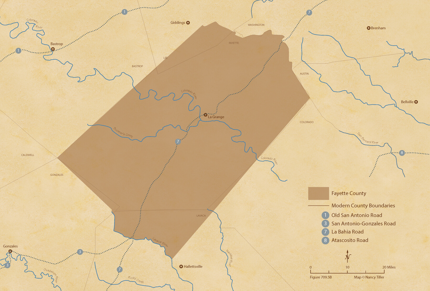
The Republic County of Fayette. Spring 1842
Figure No. 709.5 from 'A Boundary Atlas of Texas, 1821-1845' by Jim Tiller
-
Map/Doc
96135
-
Collection
Nancy and Jim Tiller Digital Collection
-
Object Dates
2020/1/1 (Creation Date)
-
People and Organizations
Jim Tiller (Author)
Nancy Tiller (Cartographer)
Gang Gong (GIS Professional)
-
Counties
Fayette
-
Subjects
Atlas County Republic of Texas Texas Boundaries
-
Height x Width
14.7 x 21.7 inches
37.3 x 55.1 cm
-
Medium
digital image
-
Comments
To purchase a digital PDF copy of "A Boundary Atlas of Texas, 1821-1845" see 96437.
Part of: Nancy and Jim Tiller Digital Collection
The Land Offices. No. 7, Milam, December 22, 1836

Print $20.00
The Land Offices. No. 7, Milam, December 22, 1836
2020
Size 23.9 x 21.7 inches
Map/Doc 96420
The Republic County of Houston. Created, June 12, 1837

Print $20.00
The Republic County of Houston. Created, June 12, 1837
2020
Size 19.7 x 21.7 inches
Map/Doc 96178
The Republic County of Matagorda. September 17, 1838

Print $20.00
The Republic County of Matagorda. September 17, 1838
2020
Size 21.0 x 21.7 inches
Map/Doc 96217
The Land Offices. No. 2, San Augustine, December 22, 1836

Print $20.00
The Land Offices. No. 2, San Augustine, December 22, 1836
2020
Size 19.7 x 18.4 inches
Map/Doc 96415
The Republic County of Shelby. Spring 1842

Print $20.00
The Republic County of Shelby. Spring 1842
2020
Size 20.0 x 21.7 inches
Map/Doc 96284
The Republic County of Gonzales. Spring 1842

Print $20.00
The Republic County of Gonzales. Spring 1842
2020
Size 14.7 x 21.7 inches
Map/Doc 96159
The Republic County of Colorado. January 29, 1842

Print $20.00
The Republic County of Colorado. January 29, 1842
2020
Size 18.4 x 21.7 inches
Map/Doc 96125
The Republic County of Harrison. June 24, 1841

Print $20.00
The Republic County of Harrison. June 24, 1841
2020
Size 18.6 x 21.7 inches
Map/Doc 96171
The Republic County of Milam. Spring 1842

Print $20.00
The Republic County of Milam. Spring 1842
2020
Size 17.4 x 21.6 inches
Map/Doc 96232
The Chief Justice County of Victoria. Lands in Conflict with Bexar and Gonzales Counties

Print $20.00
The Chief Justice County of Victoria. Lands in Conflict with Bexar and Gonzales Counties
2020
Size 23.3 x 21.7 inches
Map/Doc 96076
The Republic County of Red River. January 28, 1841

Print $20.00
The Republic County of Red River. January 28, 1841
2020
Size 21.0 x 21.7 inches
Map/Doc 96253
From Citizens of Liberty County for the Creation of a New County (Unnamed), September 7, 1840

Print $20.00
From Citizens of Liberty County for the Creation of a New County (Unnamed), September 7, 1840
2020
Size 25.0 x 21.7 inches
Map/Doc 96390
You may also like
Map of Jefferson County

Print $20.00
- Digital $50.00
Map of Jefferson County
1862
Size 22.5 x 21.9 inches
Map/Doc 3727
[San Antonio & Aransas Pass R.R. Right of Way from Eagle Lake to Brazos River]
![64256, [San Antonio & Aransas Pass R.R. Right of Way from Eagle Lake to Brazos River], General Map Collection](https://historictexasmaps.com/wmedia_w700/maps/64256.tif.jpg)
Print $40.00
- Digital $50.00
[San Antonio & Aransas Pass R.R. Right of Way from Eagle Lake to Brazos River]
1895
Size 30.8 x 124.9 inches
Map/Doc 64256
General Highway Map, Jim Wells County, Texas

Print $20.00
General Highway Map, Jim Wells County, Texas
1961
Size 18.2 x 24.6 inches
Map/Doc 79543
Edwards County Working Sketch 12

Print $20.00
- Digital $50.00
Edwards County Working Sketch 12
1922
Size 26.2 x 26.7 inches
Map/Doc 68888
Upton County Boundary File 3

Print $80.00
- Digital $50.00
Upton County Boundary File 3
Size 49.1 x 7.8 inches
Map/Doc 59534
Map of Falls County

Print $20.00
- Digital $50.00
Map of Falls County
1855
Size 21.4 x 23.9 inches
Map/Doc 3532
Current Miscellaneous File 21

Print $26.00
- Digital $50.00
Current Miscellaneous File 21
1952
Size 10.8 x 8.2 inches
Map/Doc 73865
Clay County Sketch File 23

Print $4.00
- Digital $50.00
Clay County Sketch File 23
Size 18.9 x 23.0 inches
Map/Doc 11086
Parker County Sketch File A

Print $4.00
- Digital $50.00
Parker County Sketch File A
1857
Size 7.9 x 8.2 inches
Map/Doc 33507
Nolan County Working Sketch Graphic Index

Print $20.00
- Digital $50.00
Nolan County Working Sketch Graphic Index
1935
Size 41.6 x 36.9 inches
Map/Doc 76654
Cameron County Rolled Sketch 19

Print $20.00
- Digital $50.00
Cameron County Rolled Sketch 19
1937
Size 26.0 x 21.8 inches
Map/Doc 5470
Sutton County Working Sketch 14

Print $40.00
- Digital $50.00
Sutton County Working Sketch 14
1972
Size 59.5 x 36.8 inches
Map/Doc 62357