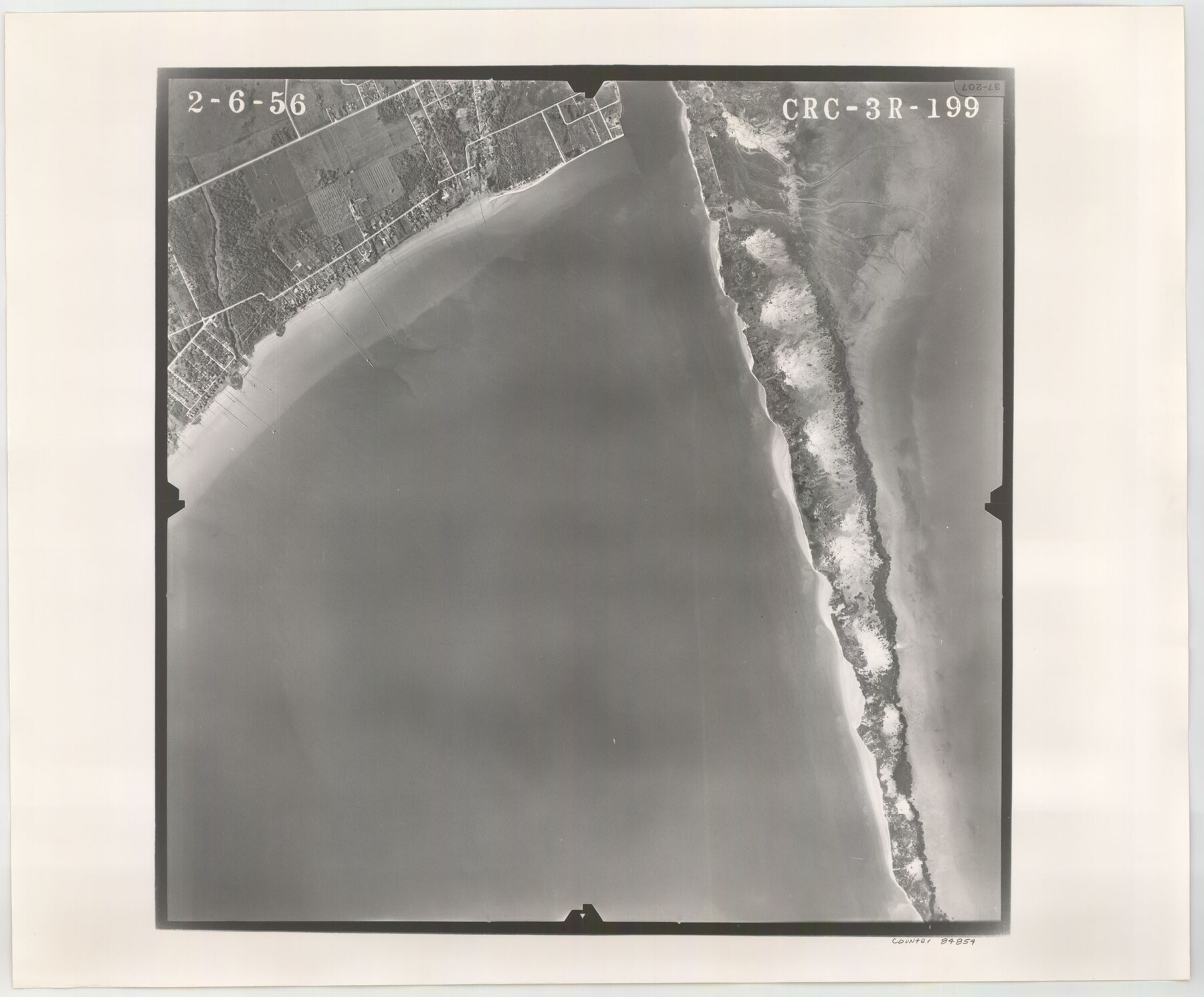
Flight Mission No. CRC-3R, Frame 199, Chambers County
CRC-3R-199
-
Map/Doc
84854
-
Collection
General Map Collection
-
Object Dates
1956/2/6 (Creation Date)
-
People and Organizations
U. S. Department of Agriculture (Publisher)
-
Counties
Chambers
-
Subjects
Aerial Photograph
-
Height x Width
18.5 x 22.3 inches
47.0 x 56.6 cm
-
Comments
Flown by Jack Ammann Photogrammetric Engineers, Inc. of San Antonio, Texas.
Part of: General Map Collection
Webb County Sketch File 11b-1

Print $20.00
- Digital $50.00
Webb County Sketch File 11b-1
1880
Size 21.7 x 19.3 inches
Map/Doc 12627
Flight Mission No. CRK-3P, Frame 178, Refugio County

Print $20.00
- Digital $50.00
Flight Mission No. CRK-3P, Frame 178, Refugio County
1956
Size 18.4 x 22.2 inches
Map/Doc 86925
Hemphill County Working Sketch 5

Print $20.00
- Digital $50.00
Hemphill County Working Sketch 5
1940
Size 31.6 x 42.4 inches
Map/Doc 66100
Flight Mission No. DQN-2K, Frame 142, Calhoun County

Print $20.00
- Digital $50.00
Flight Mission No. DQN-2K, Frame 142, Calhoun County
1953
Size 16.3 x 16.0 inches
Map/Doc 84311
Borden County Boundary File 4

Print $66.00
- Digital $50.00
Borden County Boundary File 4
1908
Size 23.7 x 125.7 inches
Map/Doc 1694
Brazoria County Working Sketch 5

Print $20.00
- Digital $50.00
Brazoria County Working Sketch 5
1921
Size 15.1 x 17.1 inches
Map/Doc 67490
Runnels County Sketch File 31

Print $6.00
Runnels County Sketch File 31
1950
Size 11.5 x 8.8 inches
Map/Doc 35496
Texas-Oklahoma (Indian Territory) Gainesville Quadrangle

Print $20.00
- Digital $50.00
Texas-Oklahoma (Indian Territory) Gainesville Quadrangle
1902
Size 21.2 x 17.2 inches
Map/Doc 75101


Knox County Working Sketch Graphic Index

Print $20.00
- Digital $50.00
Knox County Working Sketch Graphic Index
1923
Size 44.8 x 39.4 inches
Map/Doc 76611
Jones County Working Sketch 3

Print $20.00
- Digital $50.00
Jones County Working Sketch 3
1938
Size 28.7 x 25.4 inches
Map/Doc 66641
You may also like
Right of Way and Track Map, the Missouri, Kansas and Texas Ry. of Texas - Henrietta Division

Print $20.00
- Digital $50.00
Right of Way and Track Map, the Missouri, Kansas and Texas Ry. of Texas - Henrietta Division
1918
Size 11.8 x 26.9 inches
Map/Doc 64748
Map Showing Colonel A.W. Doniphan's Route through the States of New Mexico, Chihuahua and Coahuila

Print $20.00
Map Showing Colonel A.W. Doniphan's Route through the States of New Mexico, Chihuahua and Coahuila
1847
Size 16.9 x 14.0 inches
Map/Doc 79729
Fractional Township No. 11 South Range No. 27 East of the Indian Meridian, Indian Territory

Print $20.00
- Digital $50.00
Fractional Township No. 11 South Range No. 27 East of the Indian Meridian, Indian Territory
1897
Size 19.2 x 24.3 inches
Map/Doc 75247
Flight Mission No. DAG-23K, Frame 59, Matagorda County

Print $20.00
- Digital $50.00
Flight Mission No. DAG-23K, Frame 59, Matagorda County
1953
Size 18.5 x 22.3 inches
Map/Doc 86486
Uvalde County Rolled Sketch 8

Print $20.00
- Digital $50.00
Uvalde County Rolled Sketch 8
Size 21.3 x 37.5 inches
Map/Doc 8093
Colored Map of Texas Gulf Coast from Sabine River to the Rio Grande

Print $20.00
- Digital $50.00
Colored Map of Texas Gulf Coast from Sabine River to the Rio Grande
1950
Size 44.7 x 43.0 inches
Map/Doc 3014
Translations of Titles issued under the Second Contract [500 Families] of Stephen F. Austin with the Government of Coahuila & Texas - Volume 1
![94546, Translations of Titles issued under the Second Contract [500 Families] of Stephen F. Austin with the Government of Coahuila & Texas - Volume 1, Historical Volumes](https://historictexasmaps.com/wmedia_w700/pdf_converted_jpg/qi_pdf_thumbnail_39135.jpg)
Translations of Titles issued under the Second Contract [500 Families] of Stephen F. Austin with the Government of Coahuila & Texas - Volume 1
1840
Map/Doc 94546
Taylor County Sketch File 14

Print $6.00
- Digital $50.00
Taylor County Sketch File 14
1881
Size 12.9 x 8.5 inches
Map/Doc 37802
Polk County Sketch File 26a

Print $10.00
- Digital $50.00
Polk County Sketch File 26a
1878
Size 14.2 x 8.7 inches
Map/Doc 34189
Plat showing proposed Water Permit on Cow Bayou in Orange County, Texas

Print $20.00
- Digital $50.00
Plat showing proposed Water Permit on Cow Bayou in Orange County, Texas
1922
Size 24.3 x 16.4 inches
Map/Doc 93017
Colorado County Working Sketch 13

Print $20.00
- Digital $50.00
Colorado County Working Sketch 13
1943
Size 37.9 x 23.3 inches
Map/Doc 68113
De Loache's Subdivision County School Leagues Hockley County, Texas

Print $20.00
- Digital $50.00
De Loache's Subdivision County School Leagues Hockley County, Texas
1924
Size 38.6 x 36.8 inches
Map/Doc 92235