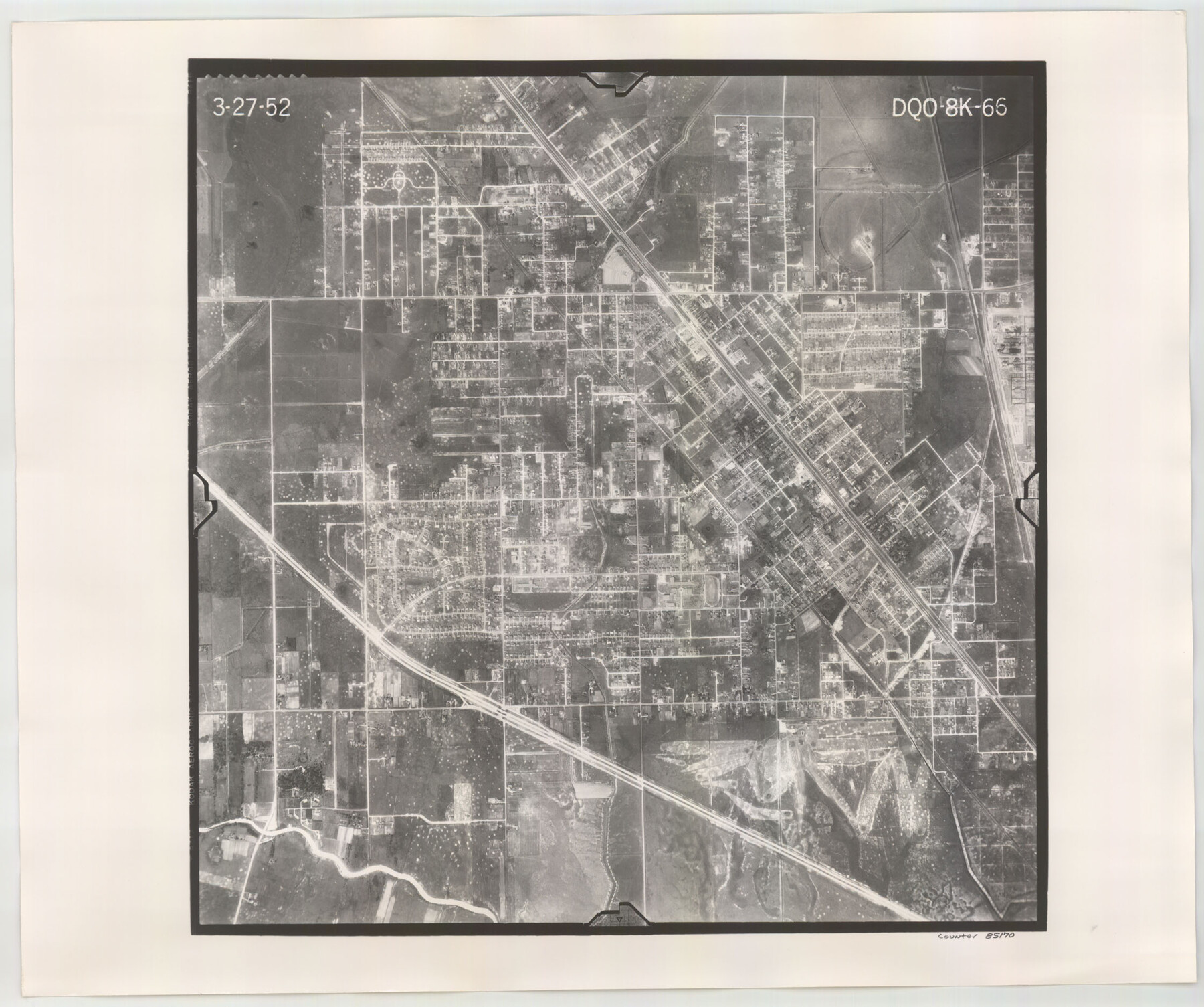
Flight Mission No. DQO-8K, Frame 66, Galveston County
DQO-8K-66
-
Map/Doc
85170
-
Collection
General Map Collection
-
Object Dates
1952/3/27 (Creation Date)
-
People and Organizations
U. S. Department of Agriculture (Publisher)
-
Counties
Galveston
-
Subjects
Aerial Photograph
-
Height x Width
18.7 x 22.4 inches
47.5 x 56.9 cm
-
Comments
Flown by Aero Exploration Company of Tulsa, Oklahoma.
Part of: General Map Collection
Castro County Sketch File 10
![17501, Castro County Sketch File 10, General Map Collection](https://historictexasmaps.com/wmedia_w700/pdf_converted_jpg/qi_pdf_thumbnail_9992.jpg)
Print $6.00
- Digital $50.00
Castro County Sketch File 10
1916
Size 8.2 x 5.4 inches
Map/Doc 17501
El Paso County Rolled Sketch 26
![8857, El Paso County Rolled Sketch 26, General Map Collection](https://historictexasmaps.com/wmedia_w700/maps/8857.tif.jpg)
Print $20.00
- Digital $50.00
El Paso County Rolled Sketch 26
Size 44.5 x 34.1 inches
Map/Doc 8857
Liberty County Rolled Sketch JP2
![10663, Liberty County Rolled Sketch JP2, General Map Collection](https://historictexasmaps.com/wmedia_w700/maps/10663-1.tif.jpg)
Print $40.00
- Digital $50.00
Liberty County Rolled Sketch JP2
1935
Size 51.8 x 12.8 inches
Map/Doc 10663
Hopkins County Sketch File 13
![26709, Hopkins County Sketch File 13, General Map Collection](https://historictexasmaps.com/wmedia_w700/pdf_converted_jpg/qi_pdf_thumbnail_11957.jpg)
Print $4.00
- Digital $50.00
Hopkins County Sketch File 13
1858
Size 12.7 x 8.2 inches
Map/Doc 26709
Flight Mission No. DAG-21K, Frame 39, Matagorda County
![86406, Flight Mission No. DAG-21K, Frame 39, Matagorda County, General Map Collection](https://historictexasmaps.com/wmedia_w700/pdf_converted_jpg/qi_pdf_thumbnail_33550.jpg)
Print $20.00
- Digital $50.00
Flight Mission No. DAG-21K, Frame 39, Matagorda County
1952
Size 18.6 x 22.3 inches
Map/Doc 86406
Val Verde Co.
![16912, Val Verde Co., General Map Collection](https://historictexasmaps.com/wmedia_w700/maps/16912.tif.jpg)
Print $20.00
- Digital $50.00
Val Verde Co.
1908
Size 42.4 x 38.7 inches
Map/Doc 16912
Freestone County Sketch File 22
![23082, Freestone County Sketch File 22, General Map Collection](https://historictexasmaps.com/wmedia_w700/pdf_converted_jpg/qi_pdf_thumbnail_11237.jpg)
Print $40.00
- Digital $50.00
Freestone County Sketch File 22
1886
Size 14.4 x 17.3 inches
Map/Doc 23082
Kimble County Working Sketch 70
![70138, Kimble County Working Sketch 70, General Map Collection](https://historictexasmaps.com/wmedia_w700/maps/70138-1.tif.jpg)
Print $20.00
- Digital $50.00
Kimble County Working Sketch 70
Size 41.2 x 25.3 inches
Map/Doc 70138
Gaines County Rolled Sketch 15A
![9036, Gaines County Rolled Sketch 15A, General Map Collection](https://historictexasmaps.com/wmedia_w700/maps/9036.tif.jpg)
Print $40.00
- Digital $50.00
Gaines County Rolled Sketch 15A
Size 90.5 x 23.8 inches
Map/Doc 9036
Comanche County Sketch File 19 1/2
![19098, Comanche County Sketch File 19 1/2, General Map Collection](https://historictexasmaps.com/wmedia_w700/pdf_converted_jpg/qi_pdf_thumbnail_10316.jpg)
Print $6.00
- Digital $50.00
Comanche County Sketch File 19 1/2
1872
Size 8.1 x 7.9 inches
Map/Doc 19098
Flight Mission No. BQR-16K, Frame 35, Brazoria County
![84102, Flight Mission No. BQR-16K, Frame 35, Brazoria County, General Map Collection](https://historictexasmaps.com/wmedia_w700/pdf_converted_jpg/qi_pdf_thumbnail_31319.jpg)
Print $20.00
- Digital $50.00
Flight Mission No. BQR-16K, Frame 35, Brazoria County
1952
Size 18.5 x 22.2 inches
Map/Doc 84102
Flight Mission No. CRE-1R, Frame 132, Jackson County
![85340, Flight Mission No. CRE-1R, Frame 132, Jackson County, General Map Collection](https://historictexasmaps.com/wmedia_w700/pdf_converted_jpg/qi_pdf_thumbnail_32541.jpg)
Print $20.00
- Digital $50.00
Flight Mission No. CRE-1R, Frame 132, Jackson County
1956
Size 16.2 x 16.0 inches
Map/Doc 85340
You may also like
Atlas Geográfico, Estadístico é Histórico de la República Mexicana
![Atlas Geografico, Estadistico e Historico de la Republica Mexicana](https://historictexasmaps.com/wmedia_w700/pdf_converted_jpg/qi_pdf_thumbnail_64346.jpg)
Atlas Geográfico, Estadístico é Histórico de la República Mexicana
Map/Doc 95689
[State Line from Southeast New Mexico to Yoakum County]
![92013, [State Line from Southeast New Mexico to Yoakum County], Twichell Survey Records](https://historictexasmaps.com/wmedia_w700/maps/92013-1.tif.jpg)
Print $20.00
- Digital $50.00
[State Line from Southeast New Mexico to Yoakum County]
Size 32.3 x 11.7 inches
Map/Doc 92013
Flight Mission No. DAG-24K, Frame 47, Matagorda County
![86534, Flight Mission No. DAG-24K, Frame 47, Matagorda County, General Map Collection](https://historictexasmaps.com/wmedia_w700/pdf_converted_jpg/qi_pdf_thumbnail_33675.jpg)
Print $20.00
- Digital $50.00
Flight Mission No. DAG-24K, Frame 47, Matagorda County
1953
Size 18.5 x 22.3 inches
Map/Doc 86534
United States - Gulf Coast - From Latitude 26° 33' to the Rio Grande Texas
![72838, United States - Gulf Coast - From Latitude 26° 33' to the Rio Grande Texas, General Map Collection](https://historictexasmaps.com/wmedia_w700/maps/72838.tif.jpg)
Print $20.00
- Digital $50.00
United States - Gulf Coast - From Latitude 26° 33' to the Rio Grande Texas
1916
Size 27.9 x 18.3 inches
Map/Doc 72838
Richland Hills Addition to Muleshoe, Bailey County, Texas
![92461, Richland Hills Addition to Muleshoe, Bailey County, Texas, Twichell Survey Records](https://historictexasmaps.com/wmedia_w700/maps/92461-1.tif.jpg)
Print $20.00
- Digital $50.00
Richland Hills Addition to Muleshoe, Bailey County, Texas
1957
Size 22.7 x 31.7 inches
Map/Doc 92461
Edwards County Rolled Sketch 37
![94459, Edwards County Rolled Sketch 37, General Map Collection](https://historictexasmaps.com/wmedia_w700/maps/94459.tif.jpg)
Print $20.00
- Digital $50.00
Edwards County Rolled Sketch 37
2018
Size 23.3 x 30.2 inches
Map/Doc 94459
Hudspeth County Sketch File 10a
![26901, Hudspeth County Sketch File 10a, General Map Collection](https://historictexasmaps.com/wmedia_w700/pdf_converted_jpg/qi_pdf_thumbnail_12030.jpg)
Print $4.00
- Digital $50.00
Hudspeth County Sketch File 10a
1902
Size 11.2 x 8.8 inches
Map/Doc 26901
Preliminary Chart of the Northwestern Part of the Gulf of Mexico - Unfinished Proof
![95308, Preliminary Chart of the Northwestern Part of the Gulf of Mexico - Unfinished Proof, Library of Congress](https://historictexasmaps.com/wmedia_w700/maps/95308.tif.jpg)
Print $40.00
Preliminary Chart of the Northwestern Part of the Gulf of Mexico - Unfinished Proof
1861
Size 31.5 x 68.9 inches
Map/Doc 95308
Comanche County Sketch File 22a
![19108, Comanche County Sketch File 22a, General Map Collection](https://historictexasmaps.com/wmedia_w700/pdf_converted_jpg/qi_pdf_thumbnail_10321.jpg)
Print $2.00
- Digital $50.00
Comanche County Sketch File 22a
Size 8.2 x 7.6 inches
Map/Doc 19108
Live Oak County Boundary File 60a
![56407, Live Oak County Boundary File 60a, General Map Collection](https://historictexasmaps.com/wmedia_w700/pdf_converted_jpg/qi_pdf_thumbnail_16437.jpg)
Print $18.00
- Digital $50.00
Live Oak County Boundary File 60a
Size 12.7 x 8.4 inches
Map/Doc 56407
Pecos County Working Sketch 123
![71596, Pecos County Working Sketch 123, General Map Collection](https://historictexasmaps.com/wmedia_w700/maps/71596.tif.jpg)
Print $20.00
- Digital $50.00
Pecos County Working Sketch 123
Size 42.4 x 24.2 inches
Map/Doc 71596
The Star of Llano County
![97175, The Star of Llano County, Save Texas History Collectibles](https://historictexasmaps.com/wmedia_w700/maps/97175.jpg)
Price $20.00
The Star of Llano County
2023
Size 3.3 x 2.8 inches
Map/Doc 97175