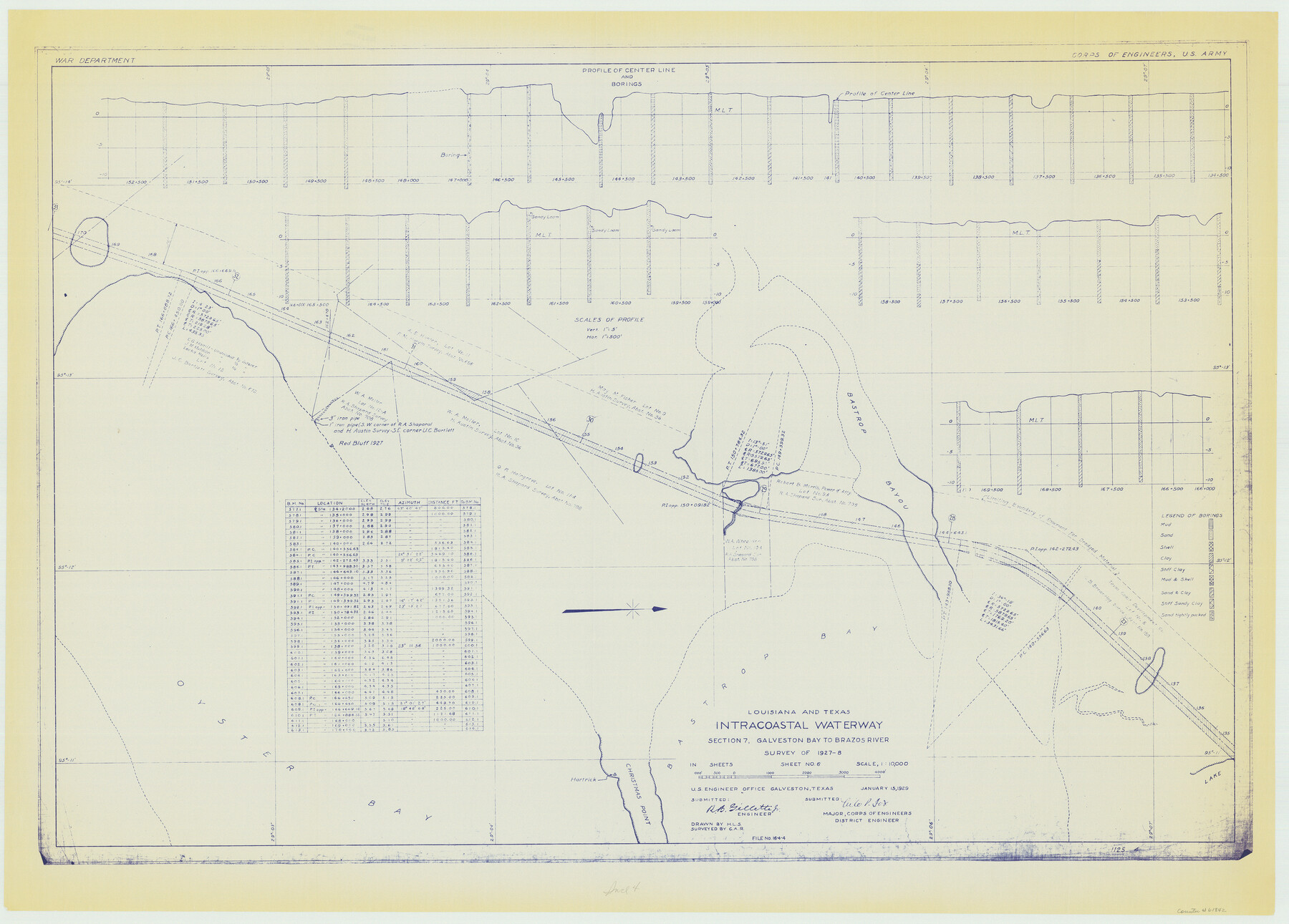
Louisiana and Texas Intracoastal Waterway, Section 7, Galveston Bay to Brazos River and Section 8, Brazos River to Matagorda Bay
-
Map/Doc
61842
-
Collection
General Map Collection
-
Object Dates
1929 (Creation Date)
-
Subjects
Intracoastal Waterways
-
Height x Width
30.8 x 43.0 inches
78.2 x 109.2 cm
Part of: General Map Collection
[Surveys near Crabapple Creek in the Bexar District]
![87, [Surveys near Crabapple Creek in the Bexar District], General Map Collection](https://historictexasmaps.com/wmedia_w700/maps/87.tif.jpg)
Print $2.00
- Digital $50.00
[Surveys near Crabapple Creek in the Bexar District]
1846
Size 9.1 x 7.0 inches
Map/Doc 87
Cottle County Rolled Sketch OX

Print $20.00
- Digital $50.00
Cottle County Rolled Sketch OX
1916
Size 29.6 x 35.8 inches
Map/Doc 8673
[Surveys in the Bexar District along the Cibolo Creek]
![98, [Surveys in the Bexar District along the Cibolo Creek], General Map Collection](https://historictexasmaps.com/wmedia_w700/maps/98.tif.jpg)
Print $2.00
- Digital $50.00
[Surveys in the Bexar District along the Cibolo Creek]
1847
Size 13.0 x 7.4 inches
Map/Doc 98
Cameron County Rolled Sketch Z6

Print $20.00
- Digital $50.00
Cameron County Rolled Sketch Z6
1937
Size 28.3 x 33.8 inches
Map/Doc 5404
Flight Mission No. DQO-12K, Frame 38, Galveston County

Print $20.00
- Digital $50.00
Flight Mission No. DQO-12K, Frame 38, Galveston County
1952
Size 18.8 x 22.5 inches
Map/Doc 85229
Val Verde County Sketch File 22

Print $20.00
- Digital $50.00
Val Verde County Sketch File 22
Size 14.3 x 22.3 inches
Map/Doc 12571

Llano County Working Sketch 9

Print $20.00
- Digital $50.00
Llano County Working Sketch 9
1979
Size 33.4 x 24.0 inches
Map/Doc 70627
Borden County Sketch File 11

Print $4.00
- Digital $50.00
Borden County Sketch File 11
1892
Size 11.0 x 8.9 inches
Map/Doc 14730
Flight Mission No. CGI-4N, Frame 181, Cameron County

Print $20.00
- Digital $50.00
Flight Mission No. CGI-4N, Frame 181, Cameron County
1955
Size 18.2 x 22.4 inches
Map/Doc 84684
Val Verde County Sketch File 47

Print $20.00
- Digital $50.00
Val Verde County Sketch File 47
1951
Size 25.1 x 18.7 inches
Map/Doc 12588
Fisher County Sketch File 1

Print $20.00
- Digital $50.00
Fisher County Sketch File 1
Size 43.5 x 18.3 inches
Map/Doc 10448
You may also like
Brewster County Working Sketch 55

Print $40.00
- Digital $50.00
Brewster County Working Sketch 55
1953
Size 51.1 x 27.5 inches
Map/Doc 67656
Coleman County Working Sketch 4

Print $20.00
- Digital $50.00
Coleman County Working Sketch 4
1918
Size 22.7 x 23.6 inches
Map/Doc 68070
Township 1 North Range 11 West, North Western District, Louisiana

Print $20.00
- Digital $50.00
Township 1 North Range 11 West, North Western District, Louisiana
1884
Size 19.6 x 24.7 inches
Map/Doc 65878
Shelby County Working Sketch 1

Print $20.00
- Digital $50.00
Shelby County Working Sketch 1
1917
Size 26.2 x 30.0 inches
Map/Doc 63854
Flight Mission No. DQN-7K, Frame 35, Calhoun County

Print $20.00
- Digital $50.00
Flight Mission No. DQN-7K, Frame 35, Calhoun County
1953
Size 18.5 x 22.1 inches
Map/Doc 84473
Hutchinson County Sketch File 4

Print $32.00
- Digital $50.00
Hutchinson County Sketch File 4
1890
Size 14.2 x 8.7 inches
Map/Doc 27179
Nueces County Sketch File 62

Print $4.00
- Digital $50.00
Nueces County Sketch File 62
1936
Size 8.6 x 14.3 inches
Map/Doc 32971
Flight Mission No. CGI-4N, Frame 24, Cameron County

Print $20.00
- Digital $50.00
Flight Mission No. CGI-4N, Frame 24, Cameron County
1954
Size 18.6 x 22.3 inches
Map/Doc 84657
Webb County Rolled Sketch 78

Print $20.00
- Digital $50.00
Webb County Rolled Sketch 78
2011
Size 33.1 x 24.6 inches
Map/Doc 90052
Culberson County Rolled Sketch 31A

Print $20.00
- Digital $50.00
Culberson County Rolled Sketch 31A
Size 43.4 x 35.6 inches
Map/Doc 8748
Zavala County

Print $20.00
- Digital $50.00
Zavala County
1894
Size 40.5 x 47.9 inches
Map/Doc 63146
Loving County Working Sketch 7

Print $20.00
- Digital $50.00
Loving County Working Sketch 7
1949
Size 23.4 x 26.3 inches
Map/Doc 70639