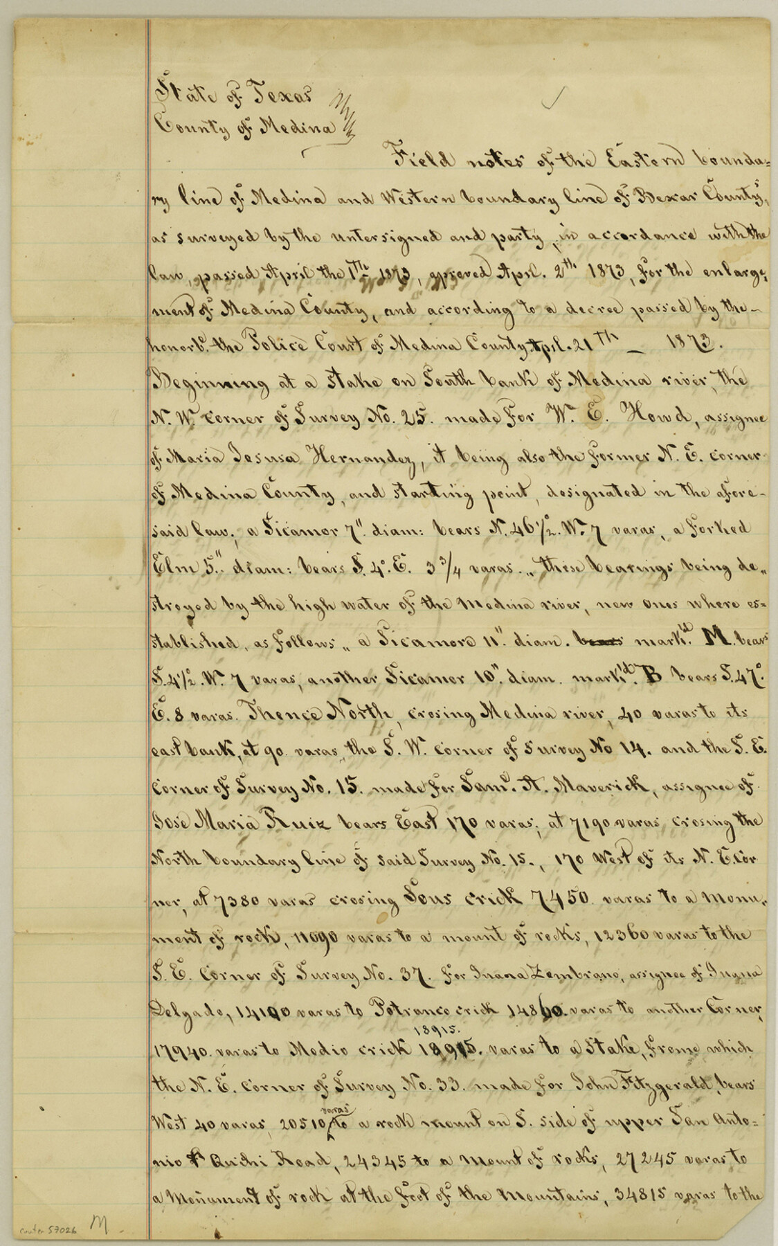
Medina County Boundary File 2
Field notes of Meda [sp.], Bexar & Bandera Co. lines
-
Map/Doc
57026
-
Collection
General Map Collection
-
Counties
Medina
-
Subjects
County Boundaries
-
Height x Width
13.0 x 8.1 inches
33.0 x 20.6 cm
Part of: General Map Collection
Chart of the Harbour of San [Luis]
![72761, Chart of the Harbour of San [Luis], General Map Collection](https://historictexasmaps.com/wmedia_w700/maps/72761.tif.jpg)
Print $20.00
- Digital $50.00
Chart of the Harbour of San [Luis]
1846
Size 27.3 x 18.3 inches
Map/Doc 72761
Trinity River, Reagor Springs Sheet/Waxahachie Creek

Print $4.00
- Digital $50.00
Trinity River, Reagor Springs Sheet/Waxahachie Creek
1931
Size 29.9 x 25.6 inches
Map/Doc 65236
Dimmit County Sketch File 11b

Print $20.00
- Digital $50.00
Dimmit County Sketch File 11b
1909
Size 30.3 x 26.7 inches
Map/Doc 11340
Map of Coryell Co.

Print $40.00
- Digital $50.00
Map of Coryell Co.
1896
Size 49.8 x 43.1 inches
Map/Doc 4921
Bosque County Working Sketch 19

Print $20.00
- Digital $50.00
Bosque County Working Sketch 19
1976
Size 28.7 x 27.7 inches
Map/Doc 67452
Hardin County Working Sketch 28

Print $20.00
- Digital $50.00
Hardin County Working Sketch 28
1956
Size 18.8 x 18.9 inches
Map/Doc 63426
Anderson County Working Sketch 13

Print $20.00
- Digital $50.00
Anderson County Working Sketch 13
1930
Size 34.0 x 21.9 inches
Map/Doc 67013
Eastland County Rolled Sketch 3

Print $20.00
- Digital $50.00
Eastland County Rolled Sketch 3
1893
Size 24.4 x 41.3 inches
Map/Doc 5773
Jefferson County Sketch File 15b

Print $26.00
- Digital $50.00
Jefferson County Sketch File 15b
Size 17.4 x 33.2 inches
Map/Doc 11869
Hudspeth County Working Sketch 14

Print $20.00
- Digital $50.00
Hudspeth County Working Sketch 14
1953
Size 24.2 x 41.2 inches
Map/Doc 66296
Flight Mission No. BRA-16M, Frame 146, Jefferson County

Print $20.00
- Digital $50.00
Flight Mission No. BRA-16M, Frame 146, Jefferson County
1953
Size 18.4 x 22.3 inches
Map/Doc 85752
Brewster County Working Sketch 99

Print $20.00
- Digital $50.00
Brewster County Working Sketch 99
1978
Size 19.4 x 21.9 inches
Map/Doc 67699
You may also like
Taylor County Sketch File 6

Print $40.00
- Digital $50.00
Taylor County Sketch File 6
Size 40.1 x 55.0 inches
Map/Doc 10382
McMullen County Working Sketch 19

Print $20.00
- Digital $50.00
McMullen County Working Sketch 19
1944
Size 26.1 x 29.2 inches
Map/Doc 70720
Knox County Working Sketch 12

Print $20.00
- Digital $50.00
Knox County Working Sketch 12
1951
Size 26.2 x 23.5 inches
Map/Doc 70254
San Augustine County Sketch File 12

Print $4.00
San Augustine County Sketch File 12
Size 12.2 x 7.9 inches
Map/Doc 35656
Part of a map showing resurvey of Capitol Leagues by R. S. Hunnicutt & Behn Cook State Surveyors

Print $20.00
- Digital $50.00
Part of a map showing resurvey of Capitol Leagues by R. S. Hunnicutt & Behn Cook State Surveyors
Size 22.2 x 17.6 inches
Map/Doc 90276
Travis County Sketch File 9

Print $4.00
- Digital $50.00
Travis County Sketch File 9
Size 12.6 x 8.2 inches
Map/Doc 38290
Township 6 North Range 14 West, North Western District, Louisiana

Print $20.00
- Digital $50.00
Township 6 North Range 14 West, North Western District, Louisiana
1841
Size 19.5 x 24.7 inches
Map/Doc 65863
Potter County Sketch

Print $20.00
- Digital $50.00
Potter County Sketch
Size 16.3 x 20.9 inches
Map/Doc 91808
McMullen County Sketch File 34

Print $25.00
- Digital $50.00
McMullen County Sketch File 34
Size 10.5 x 9.2 inches
Map/Doc 31400

Collin County Sketch File 15

Print $4.00
- Digital $50.00
Collin County Sketch File 15
1873
Size 10.0 x 8.0 inches
Map/Doc 18880
Battlefields of the Civil War

Battlefields of the Civil War
1961
Size 25.8 x 19.7 inches
Map/Doc 92374