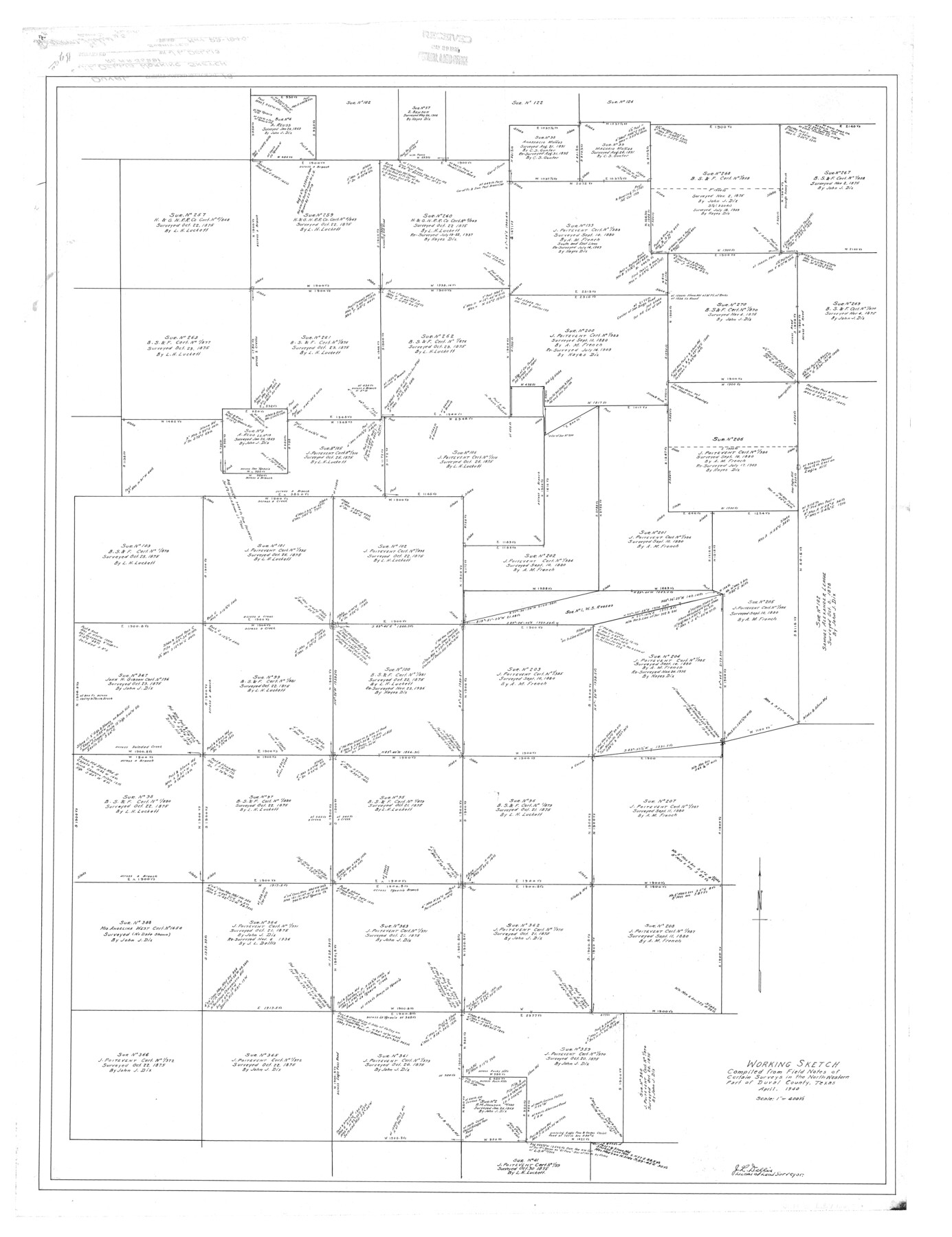
Duval County Rolled Sketch 16
Working sketch compiled from field notes of certain surveys in the northwestern part of Duval County, Texas
-
Map/Doc
8810
-
Collection
General Map Collection
-
Object Dates
1940 (Creation Date)
1940/5/29 (File Date)
-
People and Organizations
J.L. Dellis (Surveyor/Engineer)
-
Counties
Duval
-
Subjects
Surveying Rolled Sketch
-
Height x Width
45.3 x 34.8 inches
115.1 x 88.4 cm
-
Scale
1" = 400 varas
Part of: General Map Collection
Duval County Working Sketch 57

Print $20.00
- Digital $50.00
Duval County Working Sketch 57
1990
Size 30.3 x 25.4 inches
Map/Doc 68781
Rains County Sketch File 9

Print $20.00
- Digital $50.00
Rains County Sketch File 9
Size 14.2 x 16.3 inches
Map/Doc 34960
Refugio County Sketch File 13

Print $5.00
- Digital $50.00
Refugio County Sketch File 13
Size 8.2 x 10.3 inches
Map/Doc 35265
Kimble County Working Sketch 12

Print $20.00
- Digital $50.00
Kimble County Working Sketch 12
1922
Size 27.6 x 19.5 inches
Map/Doc 70080
[Ferguson State Farm]
![62991, [Ferguson State Farm], General Map Collection](https://historictexasmaps.com/wmedia_w700/maps/62991.tif.jpg)
Print $20.00
- Digital $50.00
[Ferguson State Farm]
Size 17.2 x 16.1 inches
Map/Doc 62991
Potter County Sketch File 7

Print $20.00
- Digital $50.00
Potter County Sketch File 7
Size 23.2 x 18.0 inches
Map/Doc 12197
[Surveys in Tyler County]
![352, [Surveys in Tyler County], General Map Collection](https://historictexasmaps.com/wmedia_w700/maps/352.tif.jpg)
Print $2.00
- Digital $50.00
[Surveys in Tyler County]
1847
Size 8.3 x 5.2 inches
Map/Doc 352
Crosby County Sketch File 12

Print $4.00
- Digital $50.00
Crosby County Sketch File 12
1895
Size 14.3 x 9.1 inches
Map/Doc 20034
Coryell County Sketch File 10

Print $6.00
- Digital $50.00
Coryell County Sketch File 10
1861
Size 8.6 x 7.2 inches
Map/Doc 19361
El Paso County Working Sketch 27

Print $20.00
- Digital $50.00
El Paso County Working Sketch 27
1963
Size 34.2 x 13.2 inches
Map/Doc 69049
Brazos River, Brazos River Sheet 6

Print $20.00
- Digital $50.00
Brazos River, Brazos River Sheet 6
1926
Size 27.9 x 23.0 inches
Map/Doc 69670
Schleicher County Rolled Sketch 9

Print $20.00
- Digital $50.00
Schleicher County Rolled Sketch 9
Size 22.7 x 22.0 inches
Map/Doc 7751
You may also like
Terrell County Working Sketch 32

Print $20.00
- Digital $50.00
Terrell County Working Sketch 32
1945
Size 33.0 x 36.9 inches
Map/Doc 62124
Corpus Christi Pass

Print $20.00
- Digital $50.00
Corpus Christi Pass
Size 46.2 x 41.4 inches
Map/Doc 78455
Gillespie County

Print $40.00
- Digital $50.00
Gillespie County
1945
Size 41.0 x 50.0 inches
Map/Doc 95507
Map of a part of Laguna Madre showing subdivision for mineral development

Print $20.00
- Digital $50.00
Map of a part of Laguna Madre showing subdivision for mineral development
1950
Size 40.7 x 26.9 inches
Map/Doc 2917
Jim Hogg County Working Sketch 7

Print $20.00
- Digital $50.00
Jim Hogg County Working Sketch 7
1964
Size 20.0 x 18.6 inches
Map/Doc 66593
[Sketch of surveys in the vicinity of sections 171 and 172 along Pedernales]
![91882, [Sketch of surveys in the vicinity of sections 171 and 172 along Pedernales], Twichell Survey Records](https://historictexasmaps.com/wmedia_w700/maps/91882-1.tif.jpg)
Print $20.00
- Digital $50.00
[Sketch of surveys in the vicinity of sections 171 and 172 along Pedernales]
Size 17.2 x 12.9 inches
Map/Doc 91882
Flight Mission No. DAH-9M, Frame 164, Orange County

Print $20.00
- Digital $50.00
Flight Mission No. DAH-9M, Frame 164, Orange County
1953
Size 18.6 x 22.3 inches
Map/Doc 86863
Grayson County Working Sketch 1

Print $20.00
- Digital $50.00
Grayson County Working Sketch 1
1939
Size 10.8 x 17.7 inches
Map/Doc 63240
Caldwell County Working Sketch 5

Print $20.00
- Digital $50.00
Caldwell County Working Sketch 5
1940
Size 19.9 x 27.4 inches
Map/Doc 67835
Sketch E Showing the Progress of the Survey of Section V From 1847 to 1852

Print $20.00
- Digital $50.00
Sketch E Showing the Progress of the Survey of Section V From 1847 to 1852
1852
Size 12.4 x 22.7 inches
Map/Doc 97213

Gulf Coast of the United States, Key West to Rio Grande

Print $20.00
- Digital $50.00
Gulf Coast of the United States, Key West to Rio Grande
1892
Size 27.5 x 18.3 inches
Map/Doc 72669