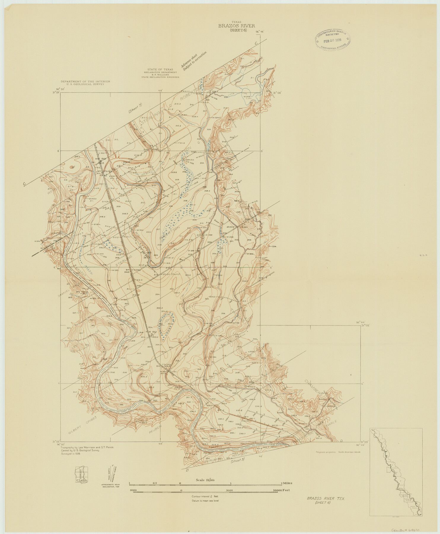
Brazos River, Brazos River Sheet 6
-
Map/Doc
69670
-
Collection
General Map Collection
-
Object Dates
1926 (Creation Date)
-
People and Organizations
Texas State Reclamation Department (Publisher)
Lee Morrison (Surveyor/Engineer)
S.T. Penick (Surveyor/Engineer)
-
Counties
Robertson Milam Falls
-
Subjects
River Surveys Topographic
-
Height x Width
27.9 x 23.0 inches
70.9 x 58.4 cm
-
Comments
Brazos River Sheet 6 located north of the Brazos River Sheet 5 and south of the Brazos River Sheet 7.
Part of: General Map Collection
Fannin County Sketch File 3

Print $4.00
- Digital $50.00
Fannin County Sketch File 3
Size 9.3 x 8.3 inches
Map/Doc 22447
[Gulf, Colorado & Santa Fe]
![64591, [Gulf, Colorado & Santa Fe], General Map Collection](https://historictexasmaps.com/wmedia_w700/maps/64591.tif.jpg)
Print $40.00
- Digital $50.00
[Gulf, Colorado & Santa Fe]
1918
Size 63.1 x 31.2 inches
Map/Doc 64591
Flight Mission No. DCL-7C, Frame 30, Kenedy County

Print $20.00
- Digital $50.00
Flight Mission No. DCL-7C, Frame 30, Kenedy County
1943
Size 15.3 x 15.1 inches
Map/Doc 86022
Nueces County Rolled Sketch 13

Print $20.00
- Digital $50.00
Nueces County Rolled Sketch 13
Size 22.1 x 28.9 inches
Map/Doc 6870
Flight Mission No. CRE-1R, Frame 123, Jackson County

Print $20.00
- Digital $50.00
Flight Mission No. CRE-1R, Frame 123, Jackson County
1956
Size 16.0 x 16.0 inches
Map/Doc 85334
Jeff Davis County Working Sketch 34

Print $20.00
- Digital $50.00
Jeff Davis County Working Sketch 34
1978
Size 20.4 x 38.0 inches
Map/Doc 66529
Val Verde County Sketch File Z16

Print $20.00
- Digital $50.00
Val Verde County Sketch File Z16
1905
Size 21.4 x 20.9 inches
Map/Doc 12557
Foard County Sketch File 11

Print $4.00
- Digital $50.00
Foard County Sketch File 11
Size 7.7 x 10.5 inches
Map/Doc 22812
Nueces County Working Sketch 2

Print $20.00
- Digital $50.00
Nueces County Working Sketch 2
1950
Size 42.0 x 15.5 inches
Map/Doc 71304
Floyd County Sketch File 9a

Print $4.00
- Digital $50.00
Floyd County Sketch File 9a
1912
Size 14.5 x 8.9 inches
Map/Doc 22699
Fannin County Working Sketch 5

Print $20.00
- Digital $50.00
Fannin County Working Sketch 5
1939
Size 11.2 x 18.1 inches
Map/Doc 69159
Lamb County Boundary File 4

Print $16.00
- Digital $50.00
Lamb County Boundary File 4
Size 11.3 x 8.7 inches
Map/Doc 56084
You may also like
Anderson County Working Sketch 17

Print $40.00
- Digital $50.00
Anderson County Working Sketch 17
1941
Size 30.3 x 48.8 inches
Map/Doc 67017
Bandera County Sketch File 29

Print $40.00
- Digital $50.00
Bandera County Sketch File 29
1939
Size 17.3 x 17.4 inches
Map/Doc 10898
Routes to HemisFair '68 : World's Fair, San Antonio, Texas, April 6 through Oct. 6, 1968 [Recto]
![94168, Hemisfair Gulf Tourgide Map [Recto], General Map Collection](https://historictexasmaps.com/wmedia_w700/maps/94168.tif.jpg)
Routes to HemisFair '68 : World's Fair, San Antonio, Texas, April 6 through Oct. 6, 1968 [Recto]
Size 18.2 x 24.2 inches
Map/Doc 94168
[Galveston, Harrisburg & San Antonio through El Paso County]
![64007, [Galveston, Harrisburg & San Antonio through El Paso County], General Map Collection](https://historictexasmaps.com/wmedia_w700/maps/64007.tif.jpg)
Print $20.00
- Digital $50.00
[Galveston, Harrisburg & San Antonio through El Paso County]
1906
Size 13.4 x 33.9 inches
Map/Doc 64007
[G. & M. Block 5]
![91802, [G. & M. Block 5], Twichell Survey Records](https://historictexasmaps.com/wmedia_w700/maps/91802-1.tif.jpg)
Print $20.00
- Digital $50.00
[G. & M. Block 5]
Size 20.3 x 12.5 inches
Map/Doc 91802
Angelina County Working Sketch 32b

Print $20.00
- Digital $50.00
Angelina County Working Sketch 32b
1955
Size 23.0 x 28.6 inches
Map/Doc 67115
Working Sketch in Lipscomb County [showing East line of County along border with Oklahoma]
![92083, Working Sketch in Lipscomb County [showing East line of County along border with Oklahoma], Twichell Survey Records](https://historictexasmaps.com/wmedia_w700/maps/92083-1.tif.jpg)
Print $20.00
- Digital $50.00
Working Sketch in Lipscomb County [showing East line of County along border with Oklahoma]
1910
Size 4.9 x 25.9 inches
Map/Doc 92083
Trinity River, Waxahachie Sheet/Waxahachie Creek

Print $6.00
- Digital $50.00
Trinity River, Waxahachie Sheet/Waxahachie Creek
1931
Size 30.1 x 32.8 inches
Map/Doc 65237
County Map of the Pan-Handle of Texas and the line of the Texas Pan-Handle Route

Print $20.00
- Digital $50.00
County Map of the Pan-Handle of Texas and the line of the Texas Pan-Handle Route
1900
Size 7.2 x 10.3 inches
Map/Doc 95888
Bandera County Sketch File 21

Print $4.00
- Digital $50.00
Bandera County Sketch File 21
Size 12.7 x 8.1 inches
Map/Doc 14010
Flight Mission No. CUG-1P, Frame 106, Kleberg County

Print $20.00
- Digital $50.00
Flight Mission No. CUG-1P, Frame 106, Kleberg County
1956
Size 18.8 x 22.3 inches
Map/Doc 86156
Bexar County Sketch File 29

Print $40.00
- Digital $50.00
Bexar County Sketch File 29
Size 11.3 x 36.7 inches
Map/Doc 10919