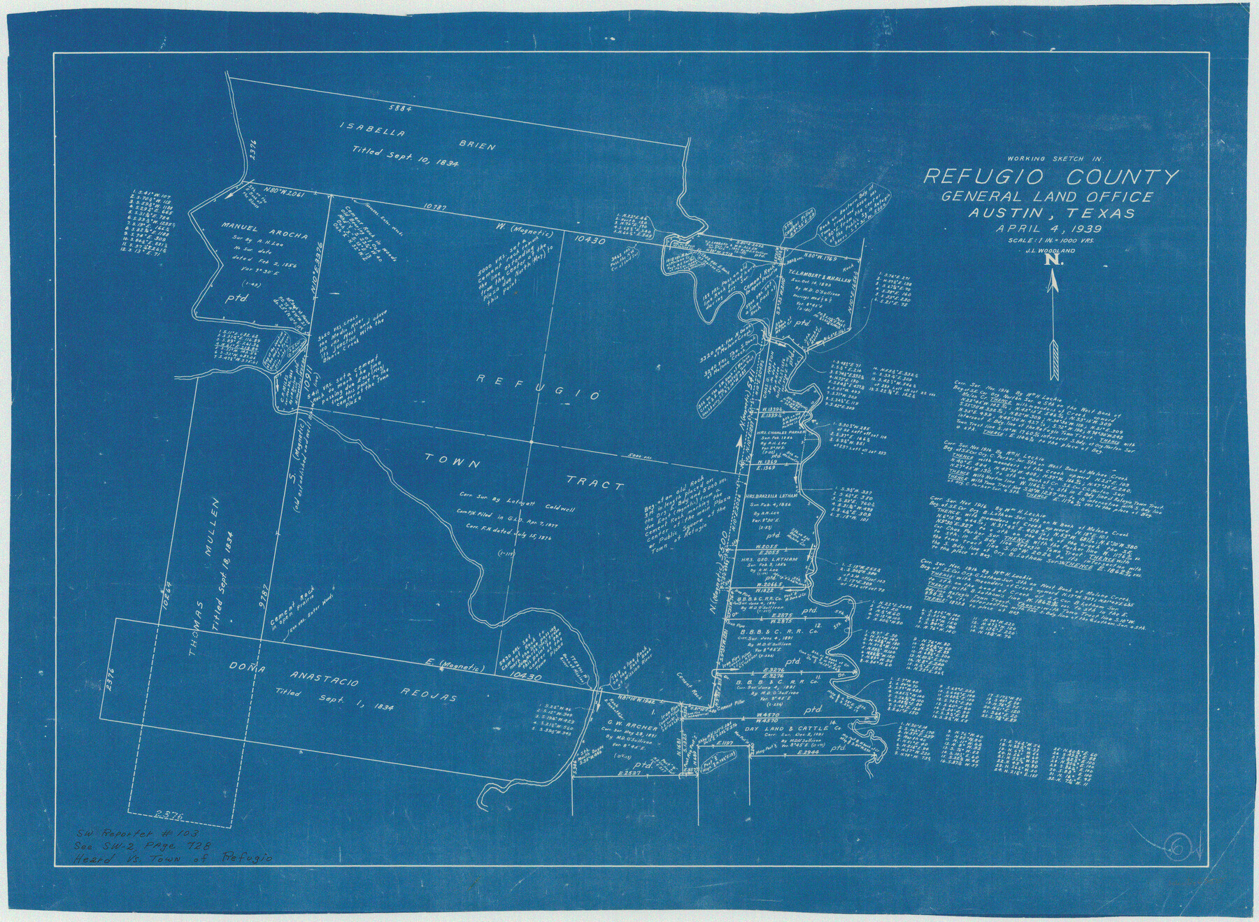
Refugio County Working Sketch 6
-
Map/Doc
63515
-
Collection
General Map Collection
-
Object Dates
4/4/1939 (Creation Date)
-
People and Organizations
J.L. Woodland (Draftsman)
-
Counties
Refugio
-
Subjects
Surveying Working Sketch
-
Height x Width
21.4 x 29.1 inches
54.4 x 73.9 cm
-
Scale
1" = 1000 varas
Part of: General Map Collection
Nueces County Rolled Sketch 75

Print $40.00
- Digital $50.00
Nueces County Rolled Sketch 75
1945
Size 56.0 x 24.0 inches
Map/Doc 9618
Duval County Sketch File 6b

Print $5.00
- Digital $50.00
Duval County Sketch File 6b
1875
Size 8.3 x 10.8 inches
Map/Doc 21290

Hopkins County Boundary File 3a

Print $4.00
- Digital $50.00
Hopkins County Boundary File 3a
Size 10.7 x 8.7 inches
Map/Doc 55082
Wood County Working Sketch 3

Print $2.00
- Digital $50.00
Wood County Working Sketch 3
1916
Size 9.8 x 8.4 inches
Map/Doc 62003
[Surveys along Seco Creek]
![268, [Surveys along Seco Creek], General Map Collection](https://historictexasmaps.com/wmedia_w700/maps/268.tif.jpg)
Print $3.00
- Digital $50.00
[Surveys along Seco Creek]
1847
Size 14.6 x 9.8 inches
Map/Doc 268
Lynn County Boundary File 12

Print $60.00
- Digital $50.00
Lynn County Boundary File 12
Size 14.0 x 17.5 inches
Map/Doc 56749
Concho County Working Sketch Graphic Index

Print $20.00
- Digital $50.00
Concho County Working Sketch Graphic Index
1947
Size 45.8 x 35.6 inches
Map/Doc 76503
Flight Mission No. CUG-3P, Frame 161, Kleberg County

Print $20.00
- Digital $50.00
Flight Mission No. CUG-3P, Frame 161, Kleberg County
1956
Size 18.6 x 22.5 inches
Map/Doc 86281
Oldham County Sketch File 14

Print $20.00
- Digital $50.00
Oldham County Sketch File 14
1904
Size 20.0 x 24.6 inches
Map/Doc 12115
Entrance to Sabine Pass, Texas from survey of May and June 1892 under the direction of Major James B. Quinn, Corps of Engineers, USA

Print $20.00
- Digital $50.00
Entrance to Sabine Pass, Texas from survey of May and June 1892 under the direction of Major James B. Quinn, Corps of Engineers, USA
1892
Size 18.8 x 32.9 inches
Map/Doc 94154
Current Miscellaneous File 37

Print $4.00
- Digital $50.00
Current Miscellaneous File 37
Size 13.2 x 8.7 inches
Map/Doc 73956
You may also like
Loving County Working Sketch 13

Print $40.00
- Digital $50.00
Loving County Working Sketch 13
1957
Size 48.4 x 34.6 inches
Map/Doc 70646
Andrews County Working Sketch 1

Print $20.00
- Digital $50.00
Andrews County Working Sketch 1
1946
Size 40.4 x 37.3 inches
Map/Doc 67047
Calhoun County Rolled Sketch 11

Print $20.00
- Digital $50.00
Calhoun County Rolled Sketch 11
1942
Size 10.6 x 40.7 inches
Map/Doc 5367
Map of 4th Section of 54.68 Miles East from Franklin, Rio Grande Division T. and P. Ry.

Print $40.00
- Digital $50.00
Map of 4th Section of 54.68 Miles East from Franklin, Rio Grande Division T. and P. Ry.
1881
Size 150.0 x 21.9 inches
Map/Doc 64639
Paul Bennett Farm

Print $20.00
- Digital $50.00
Paul Bennett Farm
Size 18.7 x 21.5 inches
Map/Doc 92409
Houston County Working Sketch 28

Print $20.00
- Digital $50.00
Houston County Working Sketch 28
1988
Size 30.2 x 37.8 inches
Map/Doc 66258
Grimes County Sketch File 4

Print $4.00
- Digital $50.00
Grimes County Sketch File 4
1872
Size 12.7 x 8.0 inches
Map/Doc 24635
Hutchinson County Working Sketch 49

Print $20.00
- Digital $50.00
Hutchinson County Working Sketch 49
1988
Size 35.2 x 37.3 inches
Map/Doc 66409
Rusk County Sketch File 11

Print $4.00
Rusk County Sketch File 11
1849
Size 8.5 x 9.1 inches
Map/Doc 35509
Bandera County Working Sketch 49

Print $20.00
- Digital $50.00
Bandera County Working Sketch 49
1983
Size 28.2 x 43.3 inches
Map/Doc 67645
El Paso County Working Sketch 21

Print $20.00
- Digital $50.00
El Paso County Working Sketch 21
1960
Size 37.8 x 30.9 inches
Map/Doc 69043
Roberts County Sketch File 5

Print $4.00
- Digital $50.00
Roberts County Sketch File 5
Size 8.0 x 9.8 inches
Map/Doc 35312