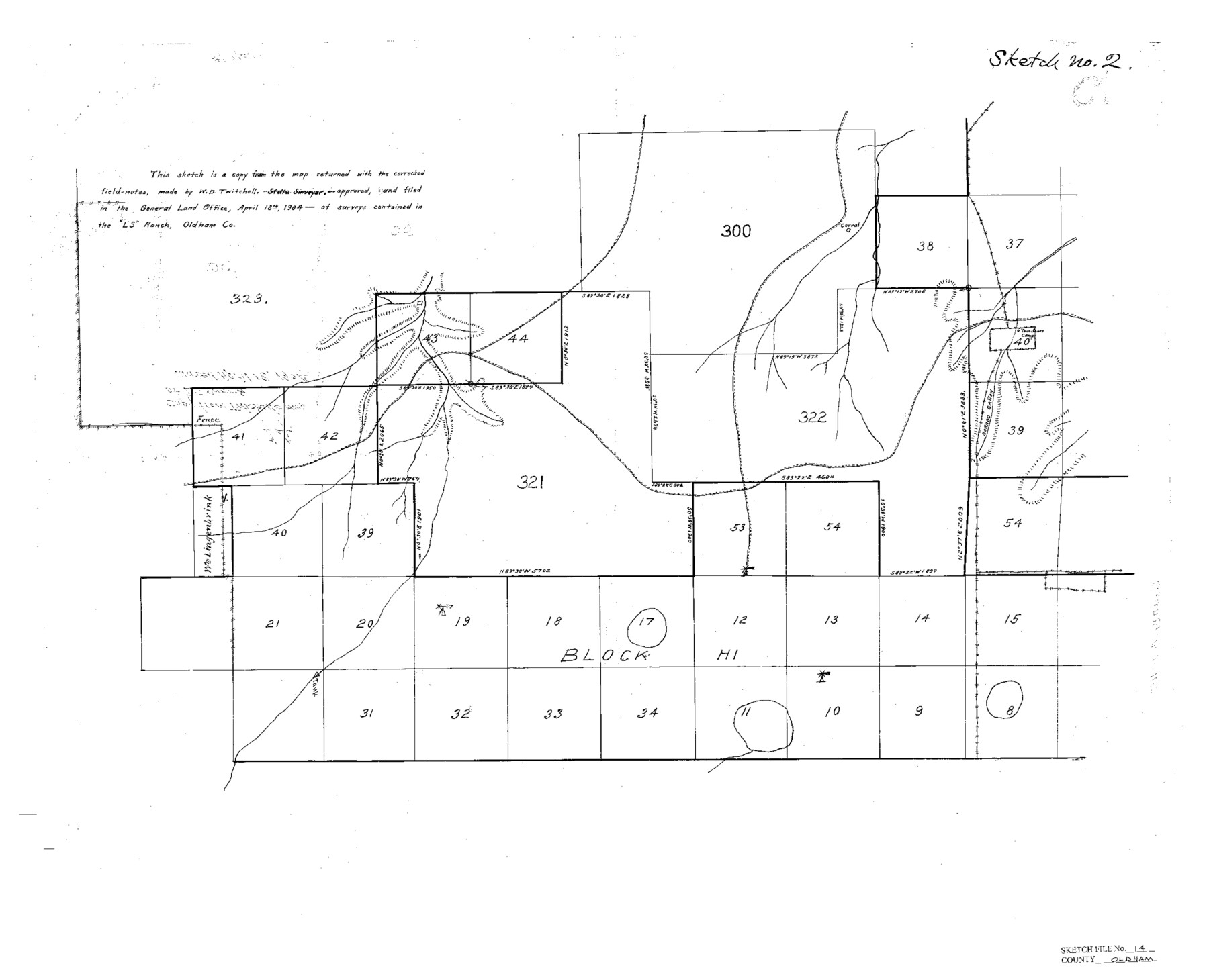
Oldham County Sketch File 14
[Sketch of surveys contained in the "LS" Ranch]
-
Map/Doc
12115
-
Collection
General Map Collection
-
Object Dates
4/18/1904 (Creation Date)
-
People and Organizations
W.D. Twichell (Surveyor/Engineer)
-
Counties
Oldham
-
Subjects
Surveying Sketch File
-
Height x Width
20.0 x 24.6 inches
50.8 x 62.5 cm
-
Medium
paper, print
Part of: General Map Collection
Cameron County Sketch File 1

Print $7.00
- Digital $50.00
Cameron County Sketch File 1
1849
Size 10.9 x 8.6 inches
Map/Doc 36024
Portion of States Submerged Area in Matagorda Bay

Print $20.00
- Digital $50.00
Portion of States Submerged Area in Matagorda Bay
1919
Size 16.8 x 17.2 inches
Map/Doc 2949
Texas Department of Corrections Prison Unit Locations

Print $20.00
- Digital $50.00
Texas Department of Corrections Prison Unit Locations
1960
Size 37.0 x 45.7 inches
Map/Doc 3104
Travis County Sketch File 12a

Print $5.00
- Digital $50.00
Travis County Sketch File 12a
1859
Size 7.9 x 9.1 inches
Map/Doc 38308
[Map of the Houston and Great Northern R. R. from Trinity River to Palestine]
![64550, [Map of the Houston and Great Northern R. R. from Trinity River to Palestine], General Map Collection](https://historictexasmaps.com/wmedia_w700/maps/64550.tif.jpg)
Print $40.00
- Digital $50.00
[Map of the Houston and Great Northern R. R. from Trinity River to Palestine]
1872
Size 30.0 x 88.0 inches
Map/Doc 64550
Comal County Rolled Sketch 2

Print $20.00
- Digital $50.00
Comal County Rolled Sketch 2
Size 21.6 x 13.0 inches
Map/Doc 5536
Maverick County Sketch File 16a

Print $9.00
- Digital $50.00
Maverick County Sketch File 16a
1886
Size 9.5 x 13.7 inches
Map/Doc 31117
Montgomery County Sketch File 12

Print $2.00
- Digital $50.00
Montgomery County Sketch File 12
Size 8.1 x 3.8 inches
Map/Doc 31802
Map and Profile of Georgetown Railroad

Print $20.00
- Digital $50.00
Map and Profile of Georgetown Railroad
1879
Size 18.9 x 41.5 inches
Map/Doc 64453
Jeff Davis County Working Sketch 45

Print $20.00
- Digital $50.00
Jeff Davis County Working Sketch 45
1990
Size 27.8 x 38.1 inches
Map/Doc 66540
Dallas County Boundary File 6d

Print $104.00
- Digital $50.00
Dallas County Boundary File 6d
Size 14.2 x 8.6 inches
Map/Doc 52229
Van Zandt County Sketch File 41

Print $13.00
- Digital $50.00
Van Zandt County Sketch File 41
Size 12.8 x 8.5 inches
Map/Doc 39489
You may also like
Val Verde County Working Sketch 29

Print $20.00
- Digital $50.00
Val Verde County Working Sketch 29
1937
Size 20.2 x 41.6 inches
Map/Doc 72164
Andrews County Working Sketch 17

Print $20.00
- Digital $50.00
Andrews County Working Sketch 17
1963
Size 30.7 x 27.1 inches
Map/Doc 67063
Duval County Sketch File 85

Print $27.00
- Digital $50.00
Duval County Sketch File 85
1935
Size 14.3 x 9.1 inches
Map/Doc 21534
Chambers County Sketch File 27

Print $12.00
- Digital $50.00
Chambers County Sketch File 27
1934
Size 11.3 x 8.8 inches
Map/Doc 17606
Maverick County Sketch File 10

Print $22.00
- Digital $50.00
Maverick County Sketch File 10
Size 8.6 x 7.0 inches
Map/Doc 31072
Aransas County Rolled Sketch 27D

Print $20.00
- Digital $50.00
Aransas County Rolled Sketch 27D
1930
Size 40.5 x 40.2 inches
Map/Doc 8418
[Mrs. May Vinson Survey]
![91869, [Mrs. May Vinson Survey], Twichell Survey Records](https://historictexasmaps.com/wmedia_w700/maps/91869-1.tif.jpg)
Print $20.00
- Digital $50.00
[Mrs. May Vinson Survey]
Size 25.5 x 14.8 inches
Map/Doc 91869
Morris County Rolled Sketch 2A

Print $20.00
- Digital $50.00
Morris County Rolled Sketch 2A
Size 24.0 x 18.9 inches
Map/Doc 10244
Collingsworth County Rolled Sketch 2

Print $20.00
- Digital $50.00
Collingsworth County Rolled Sketch 2
1888
Size 30.2 x 24.8 inches
Map/Doc 5531
McCulloch County Working Sketch 3

Print $20.00
- Digital $50.00
McCulloch County Working Sketch 3
1951
Size 30.9 x 36.8 inches
Map/Doc 70678
Angelina County Sketch File 17a

Print $8.00
- Digital $50.00
Angelina County Sketch File 17a
1863
Size 13.1 x 8.2 inches
Map/Doc 13024
Aransas County Working Sketch 1

Print $20.00
- Digital $50.00
Aransas County Working Sketch 1
1919
Size 13.8 x 27.5 inches
Map/Doc 67168