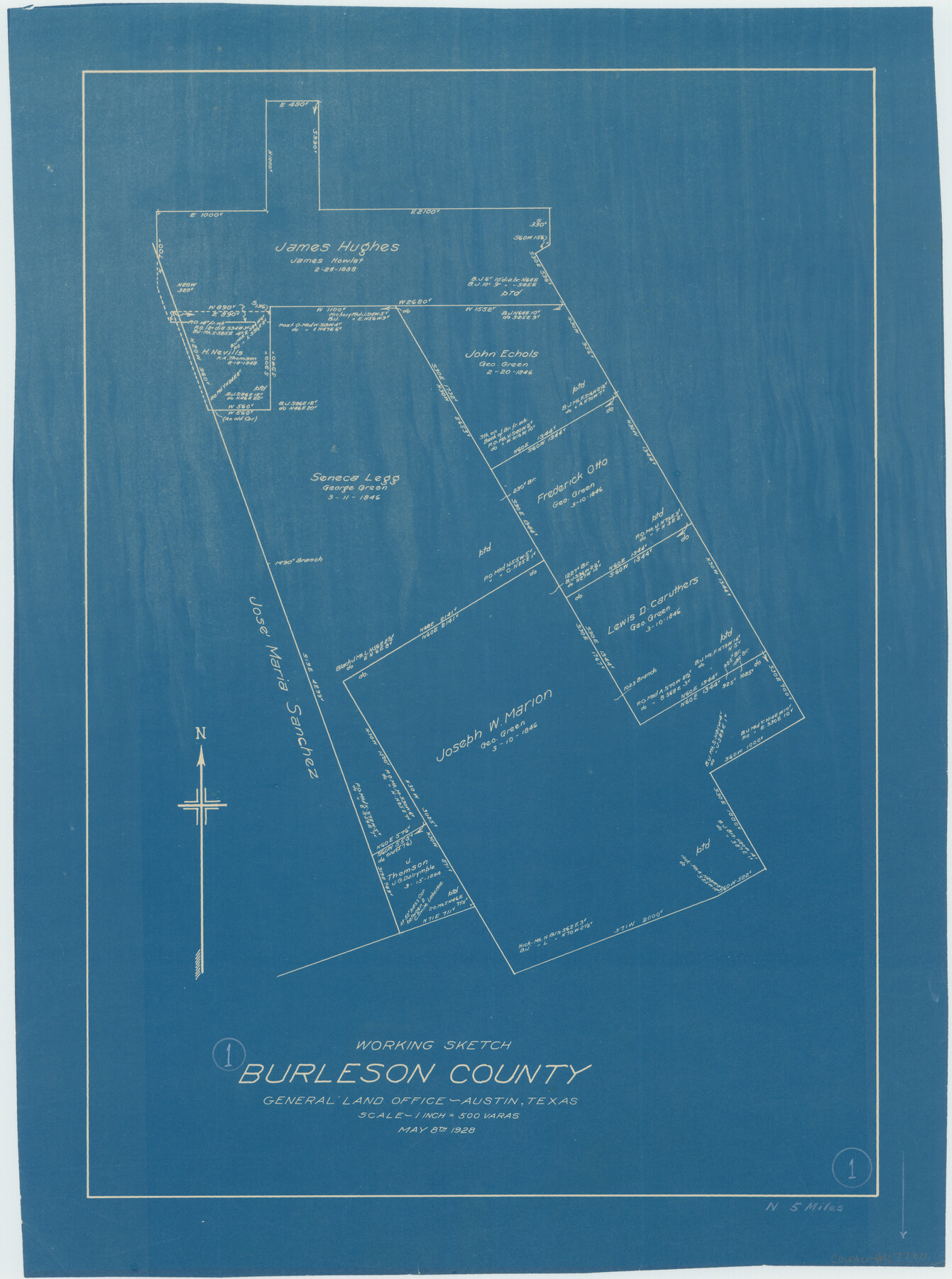
Burleson County Working Sketch 1
-
Map/Doc
67720
-
Collection
General Map Collection
-
Object Dates
5/8/1928 (Creation Date)
-
Counties
Burleson
-
Subjects
Surveying Working Sketch
-
Height x Width
23.4 x 17.4 inches
59.4 x 44.2 cm
-
Scale
1" = 500 varas
Part of: General Map Collection
Shelby County Rolled Sketch 4

Print $20.00
- Digital $50.00
Shelby County Rolled Sketch 4
1942
Size 36.4 x 43.2 inches
Map/Doc 9920
Taylor County Sketch File 17

Print $40.00
- Digital $50.00
Taylor County Sketch File 17
Size 14.5 x 17.7 inches
Map/Doc 37811
Flight Mission No. BRE-1P, Frame 104, Nueces County

Print $20.00
- Digital $50.00
Flight Mission No. BRE-1P, Frame 104, Nueces County
1956
Size 18.4 x 22.2 inches
Map/Doc 86675
Val Verde County Working Sketch 120

Print $40.00
- Digital $50.00
Val Verde County Working Sketch 120
2005
Size 30.7 x 50.0 inches
Map/Doc 83589
Williamson County Sketch File 17

Print $8.00
- Digital $50.00
Williamson County Sketch File 17
1876
Size 6.5 x 8.1 inches
Map/Doc 40338
Bee County Sketch File 4

Print $6.00
- Digital $50.00
Bee County Sketch File 4
1858
Size 16.7 x 10.0 inches
Map/Doc 14268
Glasscock County Sketch File 1

Print $46.00
- Digital $50.00
Glasscock County Sketch File 1
Size 26.1 x 31.8 inches
Map/Doc 11558
Jefferson County Rolled Sketch 17

Print $40.00
- Digital $50.00
Jefferson County Rolled Sketch 17
1931
Size 18.7 x 72.6 inches
Map/Doc 9281
Cass County Sketch File 7

Print $4.00
- Digital $50.00
Cass County Sketch File 7
1853
Size 8.0 x 12.6 inches
Map/Doc 17408
Map of Val Verde County

Print $40.00
- Digital $50.00
Map of Val Verde County
1898
Size 80.4 x 70.4 inches
Map/Doc 82014
Clay County Boundary File 3

Print $4.00
- Digital $50.00
Clay County Boundary File 3
Size 11.2 x 8.6 inches
Map/Doc 51364
Andrews County Boundary File 5

Print $40.00
- Digital $50.00
Andrews County Boundary File 5
Size 29.8 x 19.6 inches
Map/Doc 49723
You may also like
Navarro County Working Sketch 1c

Print $2.00
- Digital $50.00
Navarro County Working Sketch 1c
Size 7.1 x 10.6 inches
Map/Doc 71231
Sketch of Surveys on Peach Point, J. Perry's Property

Print $20.00
- Digital $50.00
Sketch of Surveys on Peach Point, J. Perry's Property
1832
Size 14.0 x 20.6 inches
Map/Doc 219
Map of Hill County, Texas

Print $20.00
Map of Hill County, Texas
1886
Size 22.4 x 28.3 inches
Map/Doc 88955
Freestone County State Real Property Sketch 1

Print $20.00
- Digital $50.00
Freestone County State Real Property Sketch 1
1997
Size 24.3 x 35.2 inches
Map/Doc 80128
Mitchell County Sketch File 18

Print $20.00
- Digital $50.00
Mitchell County Sketch File 18
Size 32.1 x 13.6 inches
Map/Doc 12103
Trinity River, Barnes Bridge Sheet/East Fork of Trinity River

Print $4.00
- Digital $50.00
Trinity River, Barnes Bridge Sheet/East Fork of Trinity River
1936
Size 29.5 x 22.7 inches
Map/Doc 65192
Guadalupe County Sketch File 15d

Print $4.00
- Digital $50.00
Guadalupe County Sketch File 15d
Size 10.1 x 8.1 inches
Map/Doc 24705
Township No. 4 South Range No. 14 West of the Indian Meridian

Print $4.00
- Digital $50.00
Township No. 4 South Range No. 14 West of the Indian Meridian
1875
Size 18.0 x 22.4 inches
Map/Doc 75144
Duval County Sketch File 52

Print $20.00
- Digital $50.00
Duval County Sketch File 52
1936
Size 21.0 x 28.6 inches
Map/Doc 11402
Orange County NRC Article 33.136 Sketch 4

Print $24.00
- Digital $50.00
Orange County NRC Article 33.136 Sketch 4
2011
Size 22.6 x 31.2 inches
Map/Doc 93271
Henderson County Rolled Sketch 11

Print $20.00
- Digital $50.00
Henderson County Rolled Sketch 11
1915
Size 29.4 x 42.5 inches
Map/Doc 75956
