Bee County Sketch File 3a
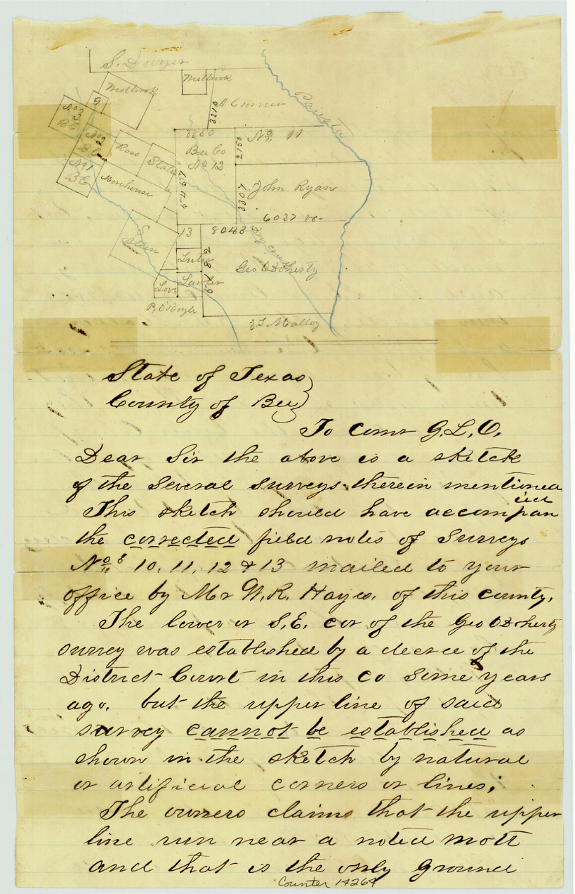
[Surveyor's statement and sketch regarding surveys on Paesta and W. Aransas Creeks, southwest of Beeville]
-
Map/Doc
14264
-
Collection
General Map Collection
-
Object Dates
1875/7/9 (Creation Date)
-
People and Organizations
J.B. Atkins (Surveyor/Engineer)
-
Counties
Bee
-
Subjects
Surveying Sketch File
-
Height x Width
12.7 x 8.2 inches
32.3 x 20.8 cm
-
Medium
paper, manuscript
-
Features
Paiesta [sic] Creek
Part of: General Map Collection
Reeves County Sketch File 26

Print $4.00
- Digital $50.00
Reeves County Sketch File 26
1964
Size 4.1 x 8.8 inches
Map/Doc 35226
Territorios de Sierragorda e Isla del Carmen

Print $20.00
- Digital $50.00
Territorios de Sierragorda e Isla del Carmen
Size 22.9 x 31.2 inches
Map/Doc 97011
Reagan County Rolled Sketch 32

Print $20.00
- Digital $50.00
Reagan County Rolled Sketch 32
Size 46.3 x 38.5 inches
Map/Doc 9827
Flight Mission No. CRC-4R, Frame 67, Chambers County

Print $20.00
- Digital $50.00
Flight Mission No. CRC-4R, Frame 67, Chambers County
1956
Size 18.8 x 22.5 inches
Map/Doc 84871
Galveston County NRC Article 33.136 Sketch 80

Print $24.00
- Digital $50.00
Galveston County NRC Article 33.136 Sketch 80
2014
Size 36.0 x 24.0 inches
Map/Doc 94987
Baylor County Sketch File 12g

Print $50.00
- Digital $50.00
Baylor County Sketch File 12g
Size 11.4 x 8.9 inches
Map/Doc 14170
Coleman County Sketch File 33

Print $2.00
- Digital $50.00
Coleman County Sketch File 33
Size 8.4 x 7.0 inches
Map/Doc 18725
Angelina County Sketch File 18c

Print $4.00
- Digital $50.00
Angelina County Sketch File 18c
Size 12.8 x 8.3 inches
Map/Doc 13034
Map of Texas with population and location of principal towns and cities according to latest reliable statistics

Print $20.00
- Digital $50.00
Map of Texas with population and location of principal towns and cities according to latest reliable statistics
1921
Size 19.0 x 22.2 inches
Map/Doc 94066
Williamson County Rolled Sketch 7

Print $40.00
- Digital $50.00
Williamson County Rolled Sketch 7
1924
Size 38.4 x 54.5 inches
Map/Doc 10146
Pecos County Rolled Sketch 103A

Print $20.00
- Digital $50.00
Pecos County Rolled Sketch 103A
1940
Size 29.3 x 33.4 inches
Map/Doc 7252
Terrell County Working Sketch 39

Print $20.00
- Digital $50.00
Terrell County Working Sketch 39
1951
Size 26.8 x 40.4 inches
Map/Doc 62132
You may also like
Garza County Sketch File 30

Print $8.00
- Digital $50.00
Garza County Sketch File 30
1959
Size 14.3 x 8.8 inches
Map/Doc 24100
Tom Green County Working Sketch 9

Print $20.00
- Digital $50.00
Tom Green County Working Sketch 9
1951
Size 31.3 x 42.2 inches
Map/Doc 69378
Bowie County Sketch File 5

Print $4.00
- Digital $50.00
Bowie County Sketch File 5
Size 10.1 x 7.5 inches
Map/Doc 14837
[Sketch showing surveys on the south side of the Canadian River, Blocks 4, M-3, M-19, M-20, 21-W, and Y-2]
![91740, [Sketch showing surveys on the south side of the Canadian River, Blocks 4, M-3, M-19, M-20, 21-W, and Y-2], Twichell Survey Records](https://historictexasmaps.com/wmedia_w700/maps/91740-1.tif.jpg)
Print $20.00
- Digital $50.00
[Sketch showing surveys on the south side of the Canadian River, Blocks 4, M-3, M-19, M-20, 21-W, and Y-2]
Size 43.4 x 25.1 inches
Map/Doc 91740
![89829, [Central Yates], Twichell Survey Records](https://historictexasmaps.com/wmedia_w700/maps/89829-1.tif.jpg)
Flight Mission No. DCL-7C, Frame 144, Kenedy County

Print $20.00
- Digital $50.00
Flight Mission No. DCL-7C, Frame 144, Kenedy County
1943
Size 18.6 x 22.5 inches
Map/Doc 86101
Flight Mission No. BRA-6M, Frame 149, Jefferson County

Print $20.00
- Digital $50.00
Flight Mission No. BRA-6M, Frame 149, Jefferson County
1953
Size 18.5 x 22.3 inches
Map/Doc 85450
Grayson County Fannin District

Print $20.00
- Digital $50.00
Grayson County Fannin District
1885
Size 40.1 x 37.7 inches
Map/Doc 4961
Jackson County Boundary File 1a

Print $12.00
- Digital $50.00
Jackson County Boundary File 1a
Size 12.8 x 8.0 inches
Map/Doc 55431

Henderson County Working Sketch 25

Print $20.00
- Digital $50.00
Henderson County Working Sketch 25
1954
Size 42.0 x 31.2 inches
Map/Doc 66158
Tom Green County Sketch File 15

Print $6.00
- Digital $50.00
Tom Green County Sketch File 15
1880
Size 13.3 x 10.9 inches
Map/Doc 38172