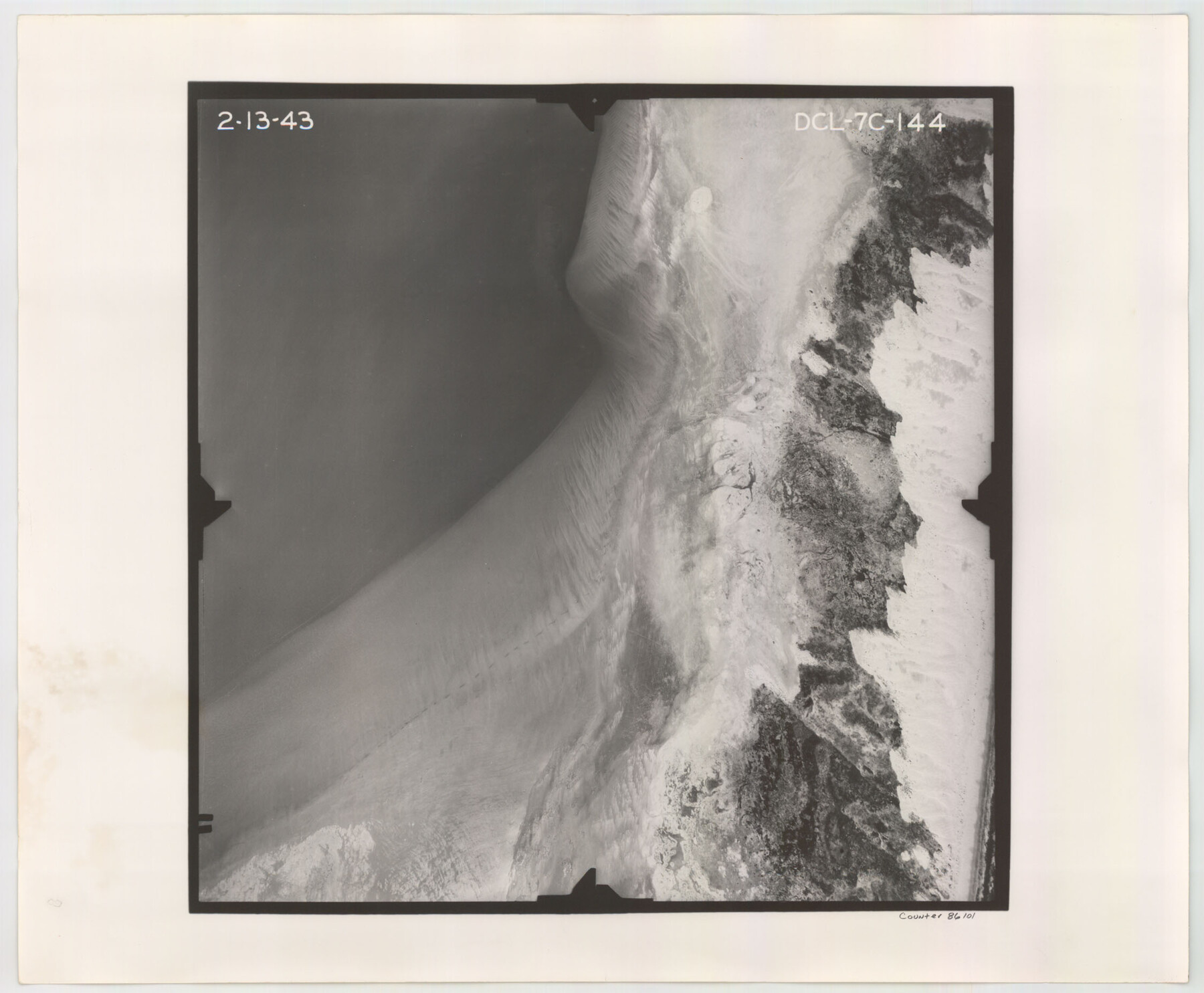
Flight Mission No. DCL-7C, Frame 144, Kenedy County
DCL-7C-144
- 
                          Map/Doc
86101
 - 
                            Collection
General Map Collection
 - 
                            Object Dates
1943/2/13 (Creation Date)
 - 
                            People and Organizations
U. S. Department of Agriculture (Publisher)
 - 
                            Counties
Kenedy
 - 
                            Subjects
Aerial Photograph
 - 
                            Height x Width
18.6 x 22.5 inches
47.2 x 57.2 cm
 - 
                            Comments
Flown by Aerial Surveys of Pittsburgh, Inc. of Pittsburgh, Pennsylvania.
 
Part of: General Map Collection
            Hutchinson County Rolled Sketch 27


                                            Print $53.00                    
                                             -                         Digital $50.00                                    
                Hutchinson County Rolled Sketch 27
1920
Size 33.3 x 27.1 inches
                                Map/Doc 6289
            
            Nacogdoches County Sketch File 16


                                            Print $20.00                    
                                             -                         Digital $50.00                                    
                Nacogdoches County Sketch File 16
1945
Size 24.6 x 18.5 inches
                                Map/Doc 42155
            
            Lampasas County Working Sketch 4


                                            Print $20.00                    
                                             -                         Digital $50.00                                    
                Lampasas County Working Sketch 4
1941
Size 23.1 x 16.8 inches
                                Map/Doc 70281
            
            Flight Mission No. BRE-2P, Frame 34, Nueces County


                                            Print $20.00                    
                                             -                         Digital $50.00                                    
                Flight Mission No. BRE-2P, Frame 34, Nueces County
1956
Size 18.7 x 22.6 inches
                                Map/Doc 86736
            
            Childress County


                                            Print $20.00                    
                                             -                         Digital $50.00                                    
                Childress County
1883
Size 20.6 x 17.4 inches
                                Map/Doc 3393
            
            McMullen County Working Sketch 43


                                            Print $20.00                    
                                             -                         Digital $50.00                                    
                McMullen County Working Sketch 43
1980
Size 35.2 x 28.1 inches
                                Map/Doc 70744
            
            Red River County Working Sketch 39


                                            Print $6.00                    
                                             -                         Digital $50.00                                    
                Red River County Working Sketch 39
1967
Size 33.4 x 23.8 inches
                                Map/Doc 72022
            
            Texas Coordinate File 7


                                            Print $4.00                    
                                             -                         Digital $50.00                                    
                Texas Coordinate File 7
Size 11.3 x 8.8 inches
                                Map/Doc 75316
            
            Upton County Working Sketch 29


                                            Print $40.00                    
                                             -                         Digital $50.00                                    
                Upton County Working Sketch 29
1956
Size 50.6 x 36.0 inches
                                Map/Doc 69525
            
            Flight Mission No. BRA-7M, Frame 79, Jefferson County


                                            Print $20.00                    
                                             -                         Digital $50.00                                    
                Flight Mission No. BRA-7M, Frame 79, Jefferson County
1953
Size 16.0 x 15.8 inches
                                Map/Doc 85501
            
            Henderson County Working Sketch 5


                                            Print $20.00                    
                                             -                         Digital $50.00                                    
                Henderson County Working Sketch 5
1918
Size 19.2 x 23.5 inches
                                Map/Doc 66138
            You may also like
            Magnetic Declination in the United States - Epoch 1980


                                            Print $20.00                    
                                             -                         Digital $50.00                                    
                Magnetic Declination in the United States - Epoch 1980
1980
Size 41.4 x 33.3 inches
                                Map/Doc 92368
            
            Pecos County Working Sketch 33


                                            Print $20.00                    
                                             -                         Digital $50.00                                    
                Pecos County Working Sketch 33
1937
Size 26.7 x 35.6 inches
                                Map/Doc 71505
            
            Map of the District of San Patricio and Nueces


                                            Print $40.00                    
                                             -                         Digital $50.00                                    
                Map of the District of San Patricio and Nueces
1847
Size 52.6 x 44.2 inches
                                Map/Doc 1956
            
            Webb County Working Sketch 58


                                            Print $20.00                    
                                             -                         Digital $50.00                                    
                Webb County Working Sketch 58
1958
Size 37.4 x 37.0 inches
                                Map/Doc 72424
            
            [Atchison, Topeka & Santa Fe from Paisano to south of Plata]


                                            Print $40.00                    
                                             -                         Digital $50.00                                    
                [Atchison, Topeka & Santa Fe from Paisano to south of Plata]
Size 32.3 x 120.8 inches
                                Map/Doc 64709
            
            Map of the Country Upon Upper Red River Explored in 1852


                                            Print $20.00                    
                                    
                Map of the Country Upon Upper Red River Explored in 1852
1852
Size 17.2 x 34.9 inches
                                Map/Doc 79726
            
            Fort Bend County Sketch File 15


                                            Print $5.00                    
                                             -                         Digital $50.00                                    
                Fort Bend County Sketch File 15
Size 11.9 x 12.8 inches
                                Map/Doc 22925
            
            Hudspeth County Rolled Sketch 17


                                            Print $40.00                    
                                             -                         Digital $50.00                                    
                Hudspeth County Rolled Sketch 17
1886
Size 22.3 x 118.5 inches
                                Map/Doc 9203
            
            Located Line of the Panhandle & Gulf Ry. through State Lands


                                            Print $40.00                    
                                             -                         Digital $50.00                                    
                Located Line of the Panhandle & Gulf Ry. through State Lands
1904
Size 12.4 x 78.0 inches
                                Map/Doc 64104
            
            Collingsworth County Working Sketch 1


                                            Print $20.00                    
                                             -                         Digital $50.00                                    
                Collingsworth County Working Sketch 1
1939
Size 43.0 x 32.8 inches
                                Map/Doc 68089
            
            The Texas and Pacific Ry. Co., Station Map, Loraine, Texas


                                            Print $20.00                    
                                             -                         Digital $50.00                                    
                The Texas and Pacific Ry. Co., Station Map, Loraine, Texas
Size 11.6 x 18.6 inches
                                Map/Doc 64683