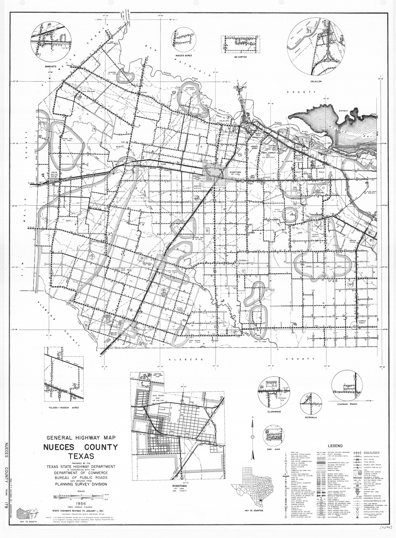
General Highway Map, Nueces County, Texas
-
Map/Doc
79615
-
Collection
Texas State Library and Archives
-
Object Dates
1961 (Creation Date)
-
People and Organizations
Texas State Highway Department (Publisher)
-
Counties
Nueces
-
Subjects
County
-
Height x Width
24.9 x 18.4 inches
63.3 x 46.7 cm
-
Comments
Prints available courtesy of the Texas State Library and Archives.
More info can be found here: TSLAC Map 05256
Part of: Texas State Library and Archives
General Highway Map, Comal County, Texas
![79417, General Highway Map, Comal County, Texas, Texas State Library and Archives](https://historictexasmaps.com/wmedia_w700/maps/79417.tif.jpg)
Print $20.00
General Highway Map, Comal County, Texas
1961
Size 18.2 x 25.0 inches
Map/Doc 79417
General Highway Map, Bexar County, Texas
![79371, General Highway Map, Bexar County, Texas, Texas State Library and Archives](https://historictexasmaps.com/wmedia_w700/maps/79371.tif.jpg)
Print $20.00
General Highway Map, Bexar County, Texas
1961
Size 18.3 x 25.0 inches
Map/Doc 79371
General Highway Map. Detail of Cities and Towns in Bexar County, Texas. City Map of San Antonio, Alamo Heights, Olmos Park, Terrell Hills, Castle Hills, Balcones Heights, and vicinity, Bexar County, Texas
![79375, General Highway Map. Detail of Cities and Towns in Bexar County, Texas. City Map of San Antonio, Alamo Heights, Olmos Park, Terrell Hills, Castle Hills, Balcones Heights, and vicinity, Bexar County, Texas, Texas State Library and Archives](https://historictexasmaps.com/wmedia_w700/maps/79375.tif.jpg)
Print $20.00
General Highway Map. Detail of Cities and Towns in Bexar County, Texas. City Map of San Antonio, Alamo Heights, Olmos Park, Terrell Hills, Castle Hills, Balcones Heights, and vicinity, Bexar County, Texas
1961
Size 18.2 x 25.0 inches
Map/Doc 79375
Map of the Country Adjacent to the Left Bank of the Rio Grande below Matamoros
![79731, Map of the Country Adjacent to the Left Bank of the Rio Grande below Matamoros, Texas State Library and Archives](https://historictexasmaps.com/wmedia_w700/maps/79731.tif.jpg)
Print $20.00
Map of the Country Adjacent to the Left Bank of the Rio Grande below Matamoros
1847
Size 27.8 x 22.8 inches
Map/Doc 79731
Principal Highways of the Southwest with particular reference to New Mexico, Oklahoma, Texas, Arkansas and Louisiana
![76302, Principal Highways of the Southwest with particular reference to New Mexico, Oklahoma, Texas, Arkansas and Louisiana, Texas State Library and Archives](https://historictexasmaps.com/wmedia_w700/maps/76302.tif.jpg)
Print $20.00
Principal Highways of the Southwest with particular reference to New Mexico, Oklahoma, Texas, Arkansas and Louisiana
1933
Size 24.3 x 18.4 inches
Map/Doc 76302
General Highway Map, Brazoria County, Texas
![79025, General Highway Map, Brazoria County, Texas, Texas State Library and Archives](https://historictexasmaps.com/wmedia_w700/maps/79025.tif.jpg)
Print $20.00
General Highway Map, Brazoria County, Texas
1939
Size 18.4 x 24.9 inches
Map/Doc 79025
General Highway Map. Detail of Cities and Towns in Travis County, Texas. City Map, Austin and vicinity, Travis County, Texas
![79687, General Highway Map. Detail of Cities and Towns in Travis County, Texas. City Map, Austin and vicinity, Travis County, Texas, Texas State Library and Archives](https://historictexasmaps.com/wmedia_w700/maps/79687.tif.jpg)
Print $20.00
General Highway Map. Detail of Cities and Towns in Travis County, Texas. City Map, Austin and vicinity, Travis County, Texas
1961
Size 18.1 x 24.7 inches
Map/Doc 79687
General Highway Map, Atascosa County, Texas
![79008, General Highway Map, Atascosa County, Texas, Texas State Library and Archives](https://historictexasmaps.com/wmedia_w700/maps/79008.tif.jpg)
Print $20.00
General Highway Map, Atascosa County, Texas
1940
Size 18.2 x 24.9 inches
Map/Doc 79008
Description of Best Route from Austin to San Antonio, Texas
![79296, Description of Best Route from Austin to San Antonio, Texas, Texas State Library and Archives](https://historictexasmaps.com/wmedia_w700/maps/79296.tif.jpg)
Print $20.00
Description of Best Route from Austin to San Antonio, Texas
1865
Size 12.9 x 13.1 inches
Map/Doc 79296
Preliminary Chart No. 31 of the Sea Coast of the United States from Galveston Bay to Matagorda Bay, Texas
![76212, Preliminary Chart No. 31 of the Sea Coast of the United States from Galveston Bay to Matagorda Bay, Texas, Texas State Library and Archives](https://historictexasmaps.com/wmedia_w700/maps/76212.tif.jpg)
Print $20.00
Preliminary Chart No. 31 of the Sea Coast of the United States from Galveston Bay to Matagorda Bay, Texas
1857
Size 21.6 x 37.2 inches
Map/Doc 76212
General Highway Map, Henderson County, Texas
![79516, General Highway Map, Henderson County, Texas, Texas State Library and Archives](https://historictexasmaps.com/wmedia_w700/maps/79516.tif.jpg)
Print $20.00
General Highway Map, Henderson County, Texas
1961
Size 24.8 x 18.2 inches
Map/Doc 79516
General Highway Map, Brooks County, Texas
![79030, General Highway Map, Brooks County, Texas, Texas State Library and Archives](https://historictexasmaps.com/wmedia_w700/maps/79030.tif.jpg)
Print $20.00
General Highway Map, Brooks County, Texas
1940
Size 18.5 x 25.0 inches
Map/Doc 79030
You may also like
Township No. 1 South Range No. 24 West of the Indian Meridian
![75173, Township No. 1 South Range No. 24 West of the Indian Meridian, General Map Collection](https://historictexasmaps.com/wmedia_w700/maps/75173.tif.jpg)
Print $20.00
- Digital $50.00
Township No. 1 South Range No. 24 West of the Indian Meridian
1875
Size 19.2 x 24.4 inches
Map/Doc 75173
Kendall County Sketch File 28
![28733, Kendall County Sketch File 28, General Map Collection](https://historictexasmaps.com/wmedia_w700/pdf_converted_jpg/qi_pdf_thumbnail_12407.jpg)
Print $12.00
- Digital $50.00
Kendall County Sketch File 28
1953
Size 14.3 x 8.9 inches
Map/Doc 28733
United States Great Lakes and adjacent waterways
![76121, United States Great Lakes and adjacent waterways, General Map Collection](https://historictexasmaps.com/wmedia_w700/maps/76121.tif.jpg)
Print $20.00
- Digital $50.00
United States Great Lakes and adjacent waterways
Size 20.8 x 42.2 inches
Map/Doc 76121
Map of Freestone County
![3561, Map of Freestone County, General Map Collection](https://historictexasmaps.com/wmedia_w700/maps/3561.tif.jpg)
Print $20.00
- Digital $50.00
Map of Freestone County
1888
Size 27.0 x 22.3 inches
Map/Doc 3561
Ownership Map NE 1/4 Lubbock County
![89896, Ownership Map NE 1/4 Lubbock County, Twichell Survey Records](https://historictexasmaps.com/wmedia_w700/maps/89896-1.tif.jpg)
Print $20.00
- Digital $50.00
Ownership Map NE 1/4 Lubbock County
Size 37.5 x 39.8 inches
Map/Doc 89896
Flight Mission No. DCL-6C, Frame 121, Kenedy County
![85951, Flight Mission No. DCL-6C, Frame 121, Kenedy County, General Map Collection](https://historictexasmaps.com/wmedia_w700/pdf_converted_jpg/qi_pdf_thumbnail_33115.jpg)
Print $20.00
- Digital $50.00
Flight Mission No. DCL-6C, Frame 121, Kenedy County
1943
Size 18.6 x 22.4 inches
Map/Doc 85951
[Fort Worth & Rio Grande Ry.] Map, Tracings of Located Line, Dublin to Comanche
![64353, [Fort Worth & Rio Grande Ry.] Map, Tracings of Located Line, Dublin to Comanche, General Map Collection](https://historictexasmaps.com/wmedia_w700/maps/64353.tif.jpg)
Print $20.00
- Digital $50.00
[Fort Worth & Rio Grande Ry.] Map, Tracings of Located Line, Dublin to Comanche
Size 15.3 x 41.6 inches
Map/Doc 64353
Irion County Sketch File 16
![27490, Irion County Sketch File 16, General Map Collection](https://historictexasmaps.com/wmedia_w700/pdf_converted_jpg/qi_pdf_thumbnail_12157.jpg)
Print $8.00
- Digital $50.00
Irion County Sketch File 16
1952
Size 11.1 x 8.7 inches
Map/Doc 27490
Newton County Sketch File 20a
![32397, Newton County Sketch File 20a, General Map Collection](https://historictexasmaps.com/wmedia_w700/pdf_converted_jpg/qi_pdf_thumbnail_13300.jpg)
Print $8.00
- Digital $50.00
Newton County Sketch File 20a
Size 3.7 x 8.8 inches
Map/Doc 32397
Township 15 South Range 15 West and Fractional Township 16 South Range 15 West, South Western District, Louisiana
![65861, Township 15 South Range 15 West and Fractional Township 16 South Range 15 West, South Western District, Louisiana, General Map Collection](https://historictexasmaps.com/wmedia_w700/maps/65861.tif.jpg)
Print $20.00
- Digital $50.00
Township 15 South Range 15 West and Fractional Township 16 South Range 15 West, South Western District, Louisiana
1875
Size 19.6 x 24.7 inches
Map/Doc 65861
Bowie County Rolled Sketch 3
![42739, Bowie County Rolled Sketch 3, General Map Collection](https://historictexasmaps.com/wmedia_w700/pdf_converted_jpg/qi_pdf_thumbnail_15396.jpg)
Print $57.00
- Digital $50.00
Bowie County Rolled Sketch 3
1970
Size 10.0 x 15.3 inches
Map/Doc 42739
Brazoria County Sketch File 44
![15068, Brazoria County Sketch File 44, General Map Collection](https://historictexasmaps.com/wmedia_w700/pdf_converted_jpg/qi_pdf_thumbnail_9568.jpg)
Print $30.00
- Digital $50.00
Brazoria County Sketch File 44
1946
Size 11.3 x 8.9 inches
Map/Doc 15068