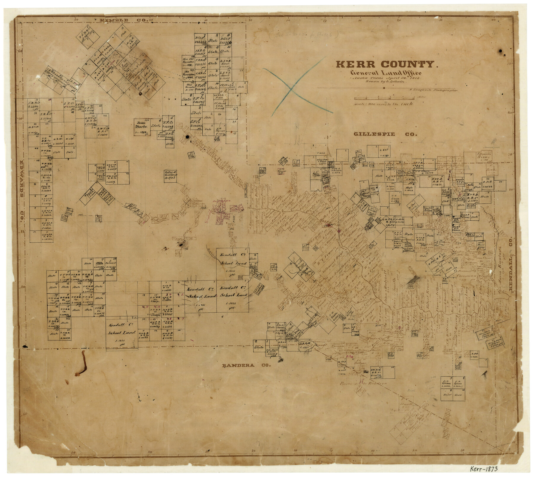
Kerr County
-
Map/Doc
3761
-
Collection
General Map Collection
-
Object Dates
4/30/1873 (Creation Date)
-
People and Organizations
Texas General Land Office (Publisher)
L. Schultz (Draftsman)
Herman Lungkwitz (Draftsman)
-
Counties
Kerr
-
Subjects
County
-
Height x Width
18.3 x 20.6 inches
46.5 x 52.3 cm
-
Features
Bear Creek
Cypress Creek
Guadalupe River
Kerrville
Tegener's Creek
Kelley's Creek
Turtle Creek
Verde Creek
Cherry Creek
Minter Creek
Camp Verde
Part of: General Map Collection
Wichita County Sketch File 19

Print $20.00
- Digital $50.00
Wichita County Sketch File 19
Size 21.9 x 22.5 inches
Map/Doc 12681
Pecos County Rolled Sketch 139

Print $40.00
- Digital $50.00
Pecos County Rolled Sketch 139
1953
Size 41.0 x 57.4 inches
Map/Doc 9732
Gaines County Sketch File 13

Print $40.00
- Digital $50.00
Gaines County Sketch File 13
1954
Size 8.9 x 20.4 inches
Map/Doc 23200
Outer Continental Shelf Leasing Maps (Louisiana Offshore Operations)

Print $20.00
- Digital $50.00
Outer Continental Shelf Leasing Maps (Louisiana Offshore Operations)
1955
Size 11.1 x 13.3 inches
Map/Doc 76090
Matagorda County NRC Article 33.136 Sketch 6

Print $42.00
- Digital $50.00
Matagorda County NRC Article 33.136 Sketch 6
2010
Size 22.0 x 34.0 inches
Map/Doc 94646
DeWitt County Working Sketch 9

Print $20.00
- Digital $50.00
DeWitt County Working Sketch 9
1979
Size 15.7 x 23.4 inches
Map/Doc 68599
Sterling County Rolled Sketch 23

Print $40.00
- Digital $50.00
Sterling County Rolled Sketch 23
Size 46.0 x 88.6 inches
Map/Doc 9954
Flight Mission No. BRA-16M, Frame 88, Jefferson County

Print $20.00
- Digital $50.00
Flight Mission No. BRA-16M, Frame 88, Jefferson County
1953
Size 18.5 x 22.3 inches
Map/Doc 85700

Kent County Boundary File 7

Print $6.00
- Digital $50.00
Kent County Boundary File 7
Size 10.8 x 8.7 inches
Map/Doc 55870
San Patricio County Working Sketch 10

Print $20.00
- Digital $50.00
San Patricio County Working Sketch 10
1939
Size 28.1 x 32.6 inches
Map/Doc 63772
Hood County Working Sketch 32

Print $20.00
- Digital $50.00
Hood County Working Sketch 32
2004
Size 28.5 x 35.6 inches
Map/Doc 83573
You may also like
Travis County Appraisal District Plat Map 1_1808

Print $20.00
- Digital $50.00
Travis County Appraisal District Plat Map 1_1808
Size 21.5 x 26.5 inches
Map/Doc 94214
Current Miscellaneous File 52

Print $12.00
- Digital $50.00
Current Miscellaneous File 52
1953
Size 12.3 x 9.3 inches
Map/Doc 74032
Right of Way and Track Map Houston & Texas Central R.R. operated by the T. and N. O. R.R. Co., Fort Worth Branch

Print $40.00
- Digital $50.00
Right of Way and Track Map Houston & Texas Central R.R. operated by the T. and N. O. R.R. Co., Fort Worth Branch
1918
Size 30.7 x 56.4 inches
Map/Doc 64542
Galveston County Sketch File 1b

Print $6.00
- Digital $50.00
Galveston County Sketch File 1b
1845
Size 16.2 x 11.0 inches
Map/Doc 23347
Land Grant Map of Comal County

Print $20.00
- Digital $50.00
Land Grant Map of Comal County
2006
Size 33.3 x 41.0 inches
Map/Doc 83601
Leon County Rolled Sketch 12

Print $20.00
- Digital $50.00
Leon County Rolled Sketch 12
1974
Size 46.5 x 40.7 inches
Map/Doc 9431
Flight Mission No. DQO-1K, Frame 152, Galveston County

Print $20.00
- Digital $50.00
Flight Mission No. DQO-1K, Frame 152, Galveston County
1952
Size 18.9 x 22.5 inches
Map/Doc 85005
Harris County Working Sketch 58

Print $20.00
- Digital $50.00
Harris County Working Sketch 58
1952
Size 24.1 x 26.5 inches
Map/Doc 65950
Culberson County Sketch File 23

Print $10.00
- Digital $50.00
Culberson County Sketch File 23
1938
Size 14.2 x 8.6 inches
Map/Doc 20238
[Lgs. 180-183, 196-198, 105-112, 678-680, 699-701, 141-143]
![90160, [Lgs. 180-183, 196-198, 105-112, 678-680, 699-701, 141-143], Twichell Survey Records](https://historictexasmaps.com/wmedia_w700/maps/90160-1.tif.jpg)
Print $20.00
- Digital $50.00
[Lgs. 180-183, 196-198, 105-112, 678-680, 699-701, 141-143]
1913
Size 28.6 x 19.1 inches
Map/Doc 90160
[Sketch showing H. & T. C. R. R. Co. Blk. 48, S. P. R. R. Co. Blk. I, and E. T. R. R. Co. Blk. I]
![89647, [Sketch showing H. & T. C. R. R. Co. Blk. 48, S. P. R. R. Co. Blk. I, and E. T. R. R. Co. Blk. I], Twichell Survey Records](https://historictexasmaps.com/wmedia_w700/maps/89647-1.tif.jpg)
Print $40.00
- Digital $50.00
[Sketch showing H. & T. C. R. R. Co. Blk. 48, S. P. R. R. Co. Blk. I, and E. T. R. R. Co. Blk. I]
Size 51.4 x 9.2 inches
Map/Doc 89647
Brewster County Rolled Sketch 24C

Print $20.00
- Digital $50.00
Brewster County Rolled Sketch 24C
Size 17.5 x 20.8 inches
Map/Doc 5210