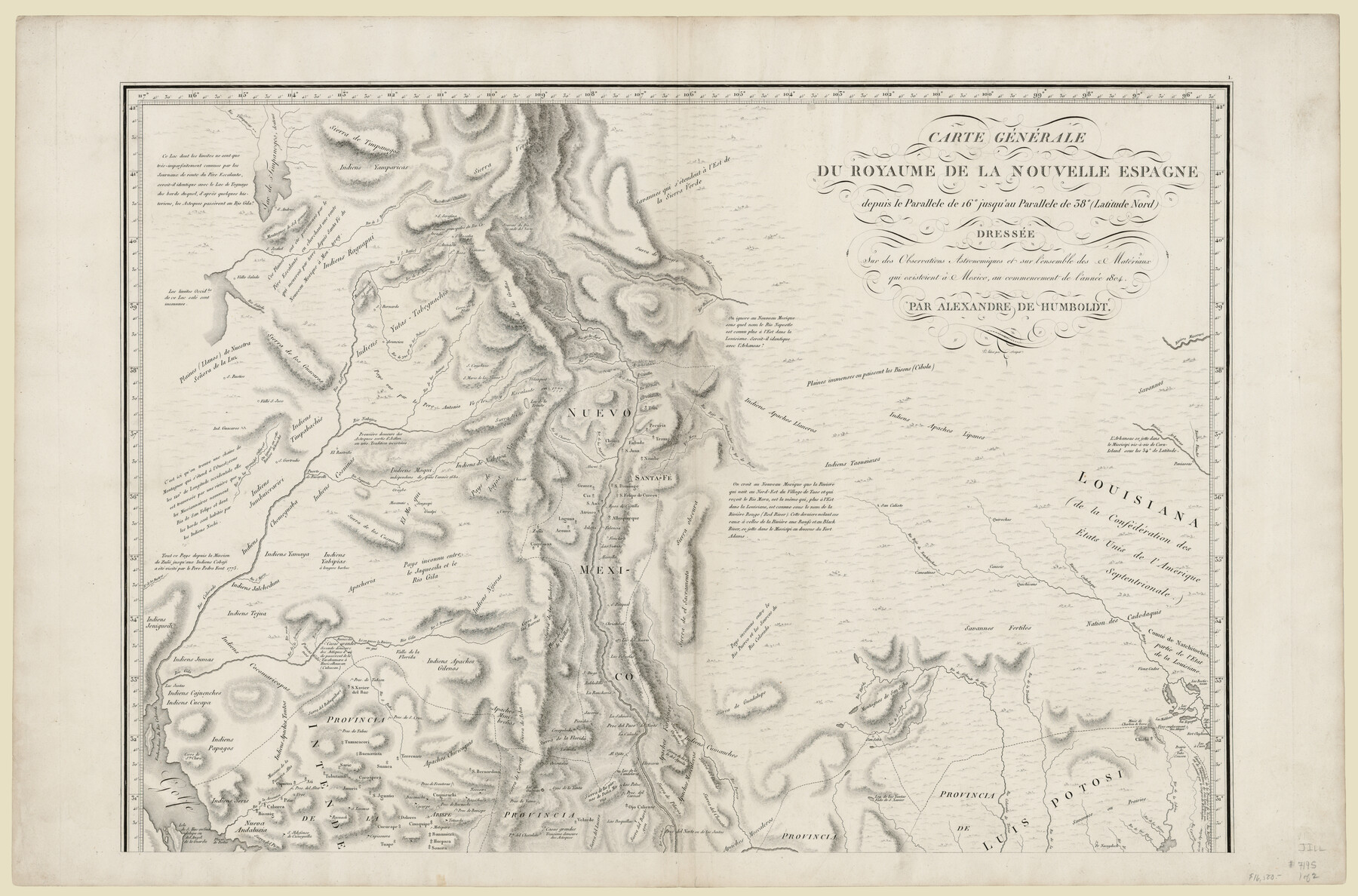
Carte Générale du Royaume de la Nouvelle Espagne depuis le Parallele de 16° jusqu'au Parallele de 38° (Latitude Nord) dressée sur des Observations Astronomiques et sur l'ensemble des Matériaux qui existoient à Mexico, au commencement de l'année 1804
-
Map/Doc
93781
-
Collection
Texana Foundation Collection
-
Object Dates
1809 (Creation Date)
-
People and Organizations
Barriere, L. Aubert (Printer)
The Texana Foundation (Donor)
Alexander von Humboldt (Draftsman)
Alexandre de Humboldt (Author)
M.M. Friesen, Oltmanns, et Thuilier (Draftsman)
-
Subjects
Mexico Spanish Texas
-
Height x Width
21.7 x 32.9 inches
55.1 x 83.6 cm
-
Medium
paper, etching/engraving/lithograph
-
Comments
North half of map. See map 93782 for south half. Donated by the Texana Foundation, May 2015.
-
URLs
https://medium.com/save-texas-history/mapping-texas-from-frontier-to-the-lone-star-state-9b537b302ced#.qzwsmdqe4
Related maps
Carte Générale du Royaume de la Nouvelle Espagne depuis le Parallele de 16° jusqu'au Parallele de 38° (Latitude Nord) dressée sur des Observations Astronomiques et sur l'ensemble des Matériaux qui existoient à Mexico, au commencement de l'année 1804

Print $20.00
- Digital $50.00
Carte Générale du Royaume de la Nouvelle Espagne depuis le Parallele de 16° jusqu'au Parallele de 38° (Latitude Nord) dressée sur des Observations Astronomiques et sur l'ensemble des Matériaux qui existoient à Mexico, au commencement de l'année 1804
1809
Size 41.7 x 33.0 inches
Map/Doc 93783
Part of: Texana Foundation Collection
Amérique Septentrionale

Print $20.00
- Digital $50.00
Amérique Septentrionale
1845
Size 14.2 x 21.0 inches
Map/Doc 93780
Map of the United States showing the Texas & Pacific Railway and its connections

Print $20.00
- Digital $50.00
Map of the United States showing the Texas & Pacific Railway and its connections
1875
Size 11.9 x 16.8 inches
Map/Doc 93960
Map of the Texas & Pacific Railway and connections

Print $20.00
- Digital $50.00
Map of the Texas & Pacific Railway and connections
1897
Size 19.8 x 24.6 inches
Map/Doc 93958
Carte Générale du Royaume de la Nouvelle Espagne depuis le Parallele de 16° jusqu'au Parallele de 38° (Latitude Nord) dressée sur des Observations Astronomiques et sur l'ensemble des Matériaux qui existoient à Mexico, au commencement de l'année 1804

Print $20.00
- Digital $50.00
Carte Générale du Royaume de la Nouvelle Espagne depuis le Parallele de 16° jusqu'au Parallele de 38° (Latitude Nord) dressée sur des Observations Astronomiques et sur l'ensemble des Matériaux qui existoient à Mexico, au commencement de l'année 1804
1809
Size 21.6 x 32.5 inches
Map/Doc 93782

Proceedings of the National Railroad Convention at St. Louis, Mo., Nov. 23 and 24, 1875, in regard to the construction of a Southern Trans-Continental Railway Line from the Mississippi Valley to the Pacific Ocean

Proceedings of the National Railroad Convention at St. Louis, Mo., Nov. 23 and 24, 1875, in regard to the construction of a Southern Trans-Continental Railway Line from the Mississippi Valley to the Pacific Ocean
Size 9.3 x 6.1 inches
Map/Doc 93961

Texas, nach den besten Quellen entw. u. gez. vom Hauptm. Radefeld

Print $20.00
- Digital $50.00
Texas, nach den besten Quellen entw. u. gez. vom Hauptm. Radefeld
1851
Size 15.0 x 18.4 inches
Map/Doc 93776
Carte Générale du Royaume de la Nouvelle Espagne depuis le Parallele de 16° jusqu'au Parallele de 38° (Latitude Nord) dressée sur des Observations Astronomiques et sur l'ensemble des Matériaux qui existoient à Mexico, au commencement de l'année 1804

Print $20.00
- Digital $50.00
Carte Générale du Royaume de la Nouvelle Espagne depuis le Parallele de 16° jusqu'au Parallele de 38° (Latitude Nord) dressée sur des Observations Astronomiques et sur l'ensemble des Matériaux qui existoient à Mexico, au commencement de l'année 1804
1809
Size 21.7 x 32.9 inches
Map/Doc 93781
Carte Générale du Royaume de la Nouvelle Espagne depuis le Parallele de 16° jusqu'au Parallele de 38° (Latitude Nord) dressée sur des Observations Astronomiques et sur l'ensemble des Matériaux qui existoient à Mexico, au commencement de l'année 1804
Print $20.00
- Digital $50.00
Carte Générale du Royaume de la Nouvelle Espagne depuis le Parallele de 16° jusqu'au Parallele de 38° (Latitude Nord) dressée sur des Observations Astronomiques et sur l'ensemble des Matériaux qui existoient à Mexico, au commencement de l'année 1804
1809
Size 41.7 x 33.0 inches
Map/Doc 93783
Mexico, California and Texas

Print $20.00
- Digital $50.00
Mexico, California and Texas
1851
Size 11.1 x 14.9 inches
Map/Doc 93779
Railroad and County Map of Texas

Print $20.00
- Digital $50.00
Railroad and County Map of Texas
1887
Size 18.0 x 23.9 inches
Map/Doc 93959
You may also like
Aransas County NRC Article 33.136 Sketch 14

Print $36.00
- Digital $50.00
Aransas County NRC Article 33.136 Sketch 14
2016
Size 18.0 x 24.0 inches
Map/Doc 94795
Flight Mission No. DAG-17K, Frame 66, Matagorda County

Print $20.00
- Digital $50.00
Flight Mission No. DAG-17K, Frame 66, Matagorda County
1952
Size 18.5 x 22.3 inches
Map/Doc 86328
Kimble County Working Sketch 23

Print $20.00
- Digital $50.00
Kimble County Working Sketch 23
1930
Size 21.6 x 18.2 inches
Map/Doc 70091
Austin County Working Sketch 7

Print $40.00
- Digital $50.00
Austin County Working Sketch 7
1992
Size 30.9 x 48.8 inches
Map/Doc 67248
Uvalde County Rolled Sketch 18

Print $20.00
- Digital $50.00
Uvalde County Rolled Sketch 18
Size 33.2 x 24.8 inches
Map/Doc 8102
Flight Mission No. DAG-4C, Frame 150, Matagorda County

Print $20.00
- Digital $50.00
Flight Mission No. DAG-4C, Frame 150, Matagorda County
1943
Size 18.5 x 18.4 inches
Map/Doc 86441
Scarborough's Map of the New England States Vermont, New Hampshire, Maine, Massachusetts, Rhode Island and Connecticut

Print $40.00
- Digital $50.00
Scarborough's Map of the New England States Vermont, New Hampshire, Maine, Massachusetts, Rhode Island and Connecticut
1910
Size 58.3 x 40.1 inches
Map/Doc 97106
Shackelford County Boundary File 7

Print $74.00
- Digital $50.00
Shackelford County Boundary File 7
Size 11.6 x 8.9 inches
Map/Doc 58671
Progressive Military Map of the United States, Southern Department, Sheet 403N, Comstock

Print $20.00
- Digital $50.00
Progressive Military Map of the United States, Southern Department, Sheet 403N, Comstock
1916
Size 35.0 x 23.9 inches
Map/Doc 92062
Survey of the Mexican Lines of Defence at Cerro Gordo, and the lines of attack of the American Army under Major General Scott, on the 17th and 18th of April, 1847

Print $20.00
- Digital $50.00
Survey of the Mexican Lines of Defence at Cerro Gordo, and the lines of attack of the American Army under Major General Scott, on the 17th and 18th of April, 1847
1847
Size 15.3 x 21.6 inches
Map/Doc 95830
Trinity River, Balltown Sheet/Pilot Grove Creek

Print $20.00
- Digital $50.00
Trinity River, Balltown Sheet/Pilot Grove Creek
1938
Size 40.1 x 33.7 inches
Map/Doc 65196
Armstrong County Boundary File 5

Print $8.00
- Digital $50.00
Armstrong County Boundary File 5
Size 11.2 x 8.9 inches
Map/Doc 50149