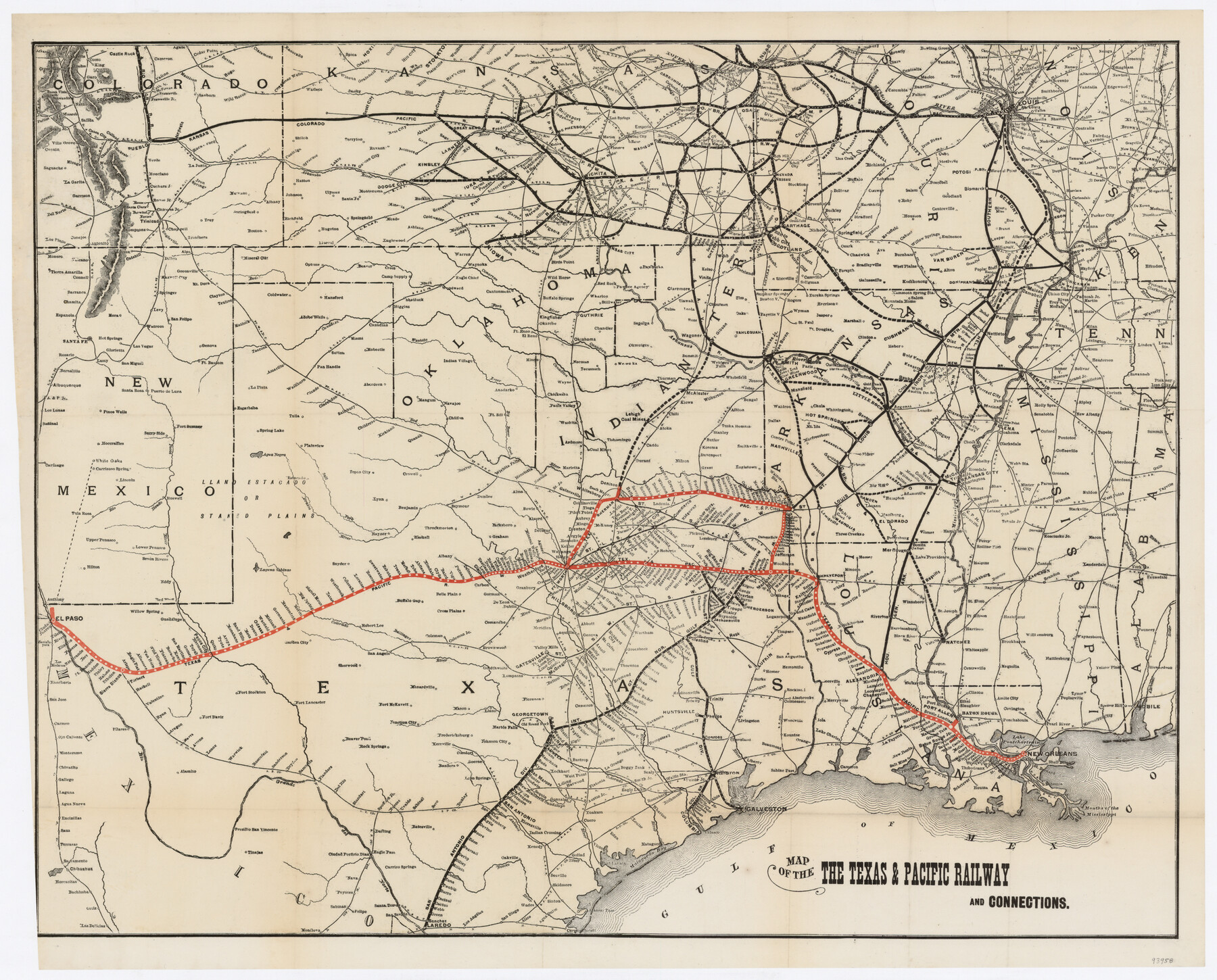
Map of the Texas & Pacific Railway and connections
-
Map/Doc
93958
-
Collection
Texana Foundation Collection
-
Object Dates
1897 (Creation Date)
2015/11/2 (File Date)
-
People and Organizations
The Texana Foundation (Donor)
-
Subjects
Railroads State of Texas
-
Height x Width
19.8 x 24.6 inches
50.3 x 62.5 cm
-
Medium
paper, etching/engraving/lithograph
-
Comments
Map from the "Annual Report of the Directors of the Texas and Pacific Railway Co. to the stockholders for the fiscal year ending December 31, 1896". Donated by the Texana Foundation, November 2015.
Part of: Texana Foundation Collection
Map of the United States showing the Texas & Pacific Railway and its connections

Print $20.00
- Digital $50.00
Map of the United States showing the Texas & Pacific Railway and its connections
1875
Size 11.9 x 16.8 inches
Map/Doc 93960
Proceedings of the National Railroad Convention at St. Louis, Mo., Nov. 23 and 24, 1875, in regard to the construction of a Southern Trans-Continental Railway Line from the Mississippi Valley to the Pacific Ocean

Proceedings of the National Railroad Convention at St. Louis, Mo., Nov. 23 and 24, 1875, in regard to the construction of a Southern Trans-Continental Railway Line from the Mississippi Valley to the Pacific Ocean
Size 9.3 x 6.1 inches
Map/Doc 93961

Carte Générale du Royaume de la Nouvelle Espagne depuis le Parallele de 16° jusqu'au Parallele de 38° (Latitude Nord) dressée sur des Observations Astronomiques et sur l'ensemble des Matériaux qui existoient à Mexico, au commencement de l'année 1804

Print $20.00
- Digital $50.00
Carte Générale du Royaume de la Nouvelle Espagne depuis le Parallele de 16° jusqu'au Parallele de 38° (Latitude Nord) dressée sur des Observations Astronomiques et sur l'ensemble des Matériaux qui existoient à Mexico, au commencement de l'année 1804
1809
Size 21.6 x 32.5 inches
Map/Doc 93782
Map of the Texas & Pacific Railway and connections

Print $20.00
- Digital $50.00
Map of the Texas & Pacific Railway and connections
1897
Size 19.8 x 24.6 inches
Map/Doc 93958
Mexico, California and Texas

Print $20.00
- Digital $50.00
Mexico, California and Texas
1851
Size 11.1 x 14.9 inches
Map/Doc 93779
Amérique Septentrionale

Print $20.00
- Digital $50.00
Amérique Septentrionale
1845
Size 14.2 x 21.0 inches
Map/Doc 93780

Map of East Texas Oil Field

Print $20.00
- Digital $50.00
Map of East Texas Oil Field
1933
Size 16.5 x 17.8 inches
Map/Doc 93949
Carte Générale du Royaume de la Nouvelle Espagne depuis le Parallele de 16° jusqu'au Parallele de 38° (Latitude Nord) dressée sur des Observations Astronomiques et sur l'ensemble des Matériaux qui existoient à Mexico, au commencement de l'année 1804

Print $20.00
- Digital $50.00
Carte Générale du Royaume de la Nouvelle Espagne depuis le Parallele de 16° jusqu'au Parallele de 38° (Latitude Nord) dressée sur des Observations Astronomiques et sur l'ensemble des Matériaux qui existoient à Mexico, au commencement de l'année 1804
1809
Size 41.7 x 33.0 inches
Map/Doc 93783
Texas, nach den besten Quellen entw. u. gez. vom Hauptm. Radefeld

Print $20.00
- Digital $50.00
Texas, nach den besten Quellen entw. u. gez. vom Hauptm. Radefeld
1851
Size 15.0 x 18.4 inches
Map/Doc 93776
Railroad and County Map of Texas

Print $20.00
- Digital $50.00
Railroad and County Map of Texas
1887
Size 18.0 x 23.9 inches
Map/Doc 93959
You may also like
Bee County Sketch File 8a

Print $8.00
- Digital $50.00
Bee County Sketch File 8a
1874
Size 6.0 x 7.6 inches
Map/Doc 14283
Palo Pinto County Working Sketch 7

Print $20.00
- Digital $50.00
Palo Pinto County Working Sketch 7
1922
Map/Doc 71390
Map of McLennan Co[unty]
![88974, Map of McLennan Co[unty], Library of Congress](https://historictexasmaps.com/wmedia_w700/maps/88974.tif.jpg)
Print $40.00
Map of McLennan Co[unty]
1896
Size 47.9 x 53.6 inches
Map/Doc 88974
General Highway Map, Baylor County, Texas

Print $20.00
General Highway Map, Baylor County, Texas
1940
Size 18.3 x 25.1 inches
Map/Doc 79013
Colorado County Sketch File 32

Print $4.00
- Digital $50.00
Colorado County Sketch File 32
1847
Size 13.0 x 8.4 inches
Map/Doc 18986
Map of Hale County

Print $20.00
- Digital $50.00
Map of Hale County
1900
Size 47.8 x 38.6 inches
Map/Doc 66847
Runnels County Sketch File 7

Print $5.00
Runnels County Sketch File 7
Size 8.3 x 7.7 inches
Map/Doc 35444
Flight Mission No. DCL-6C, Frame 112, Kenedy County

Print $20.00
- Digital $50.00
Flight Mission No. DCL-6C, Frame 112, Kenedy County
1943
Size 15.4 x 15.5 inches
Map/Doc 85942
Liberty County Sketch File M

Print $20.00
- Digital $50.00
Liberty County Sketch File M
1879
Size 16.9 x 14.5 inches
Map/Doc 12000
Galveston County Sketch File 59

Print $8.00
- Digital $50.00
Galveston County Sketch File 59
1977
Size 14.2 x 8.7 inches
Map/Doc 23607
Hill County Sketch File 26

Print $12.00
- Digital $50.00
Hill County Sketch File 26
1892
Size 8.9 x 8.5 inches
Map/Doc 26522
Hale County Rolled Sketch 9

Print $20.00
- Digital $50.00
Hale County Rolled Sketch 9
Size 25.1 x 17.6 inches
Map/Doc 6047