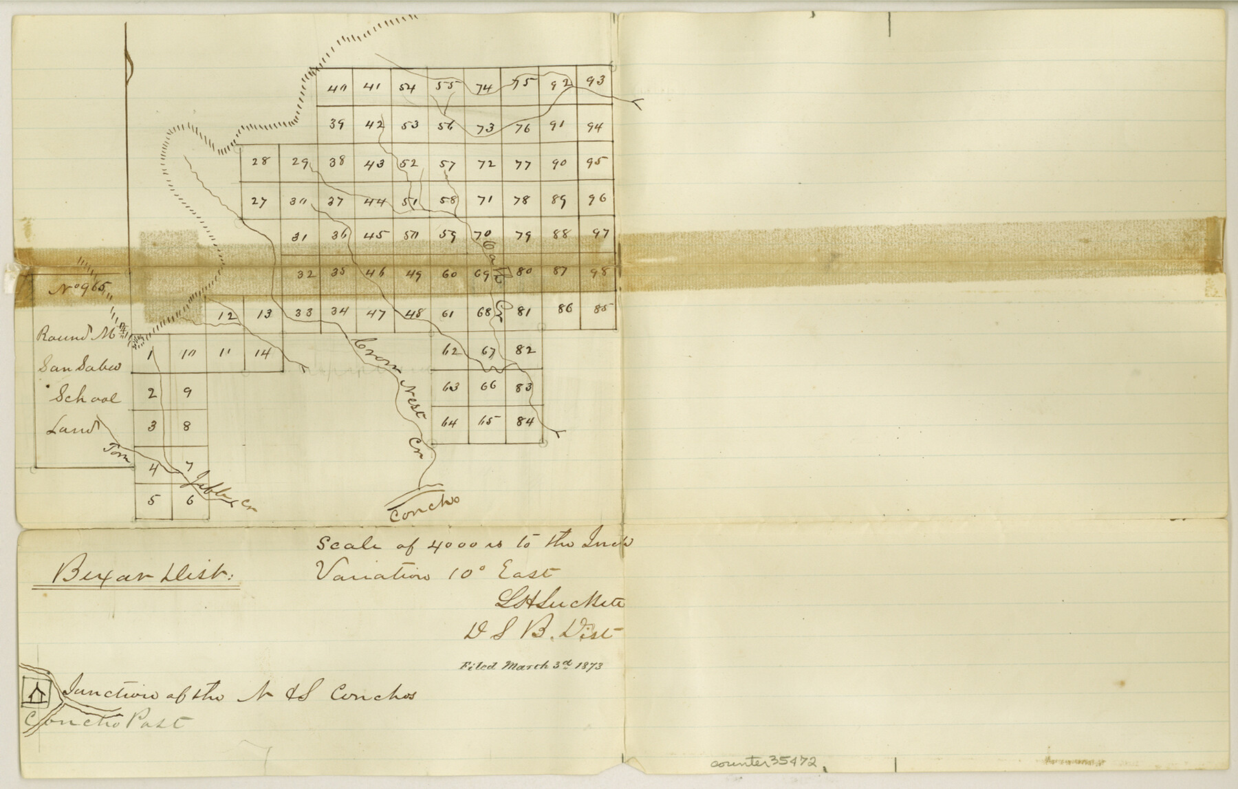
Runnels County Sketch File 7
[Sketch of surveys near Crow Nest Creek in Block 301 and adjacent areas in the southwest corner of Runnels County and extending into Tom Green County]
-
Map/Doc
35444
-
Collection
General Map Collection
-
Object Dates
3/3/1873 (File Date)
-
People and Organizations
L.H. Luckett (Surveyor/Engineer)
-
Counties
Runnels Tom Green
-
Subjects
Surveying Sketch File
-
Height x Width
8.3 x 7.7 inches
21.1 x 19.6 cm
-
Medium
paper, manuscript
-
Scale
1" = 4000 varas
Part of: General Map Collection
Territorios de Sierragorda e Isla del Carmen

Print $20.00
- Digital $50.00
Territorios de Sierragorda e Isla del Carmen
Size 22.9 x 31.2 inches
Map/Doc 97011
Presidio County Rolled Sketch 131A

Print $20.00
- Digital $50.00
Presidio County Rolled Sketch 131A
Size 47.5 x 36.6 inches
Map/Doc 10711
San Jacinto County Sketch File 23

Print $26.00
San Jacinto County Sketch File 23
1993
Size 14.6 x 8.8 inches
Map/Doc 35803
Harris County Rolled Sketch 7b

Print $20.00
- Digital $50.00
Harris County Rolled Sketch 7b
Size 47.8 x 42.4 inches
Map/Doc 9853
Edwards County Working Sketch 129

Print $20.00
- Digital $50.00
Edwards County Working Sketch 129
1981
Size 33.6 x 41.3 inches
Map/Doc 69005
Flight Mission No. CLL-1N, Frame 187, Willacy County

Print $20.00
- Digital $50.00
Flight Mission No. CLL-1N, Frame 187, Willacy County
1954
Size 18.4 x 22.1 inches
Map/Doc 87057
Flight Mission No. DCL-7C, Frame 109, Kenedy County

Print $20.00
- Digital $50.00
Flight Mission No. DCL-7C, Frame 109, Kenedy County
1943
Size 18.6 x 22.2 inches
Map/Doc 86074
[Surveys along Bosque and Hog Creek]
![238, [Surveys along Bosque and Hog Creek], General Map Collection](https://historictexasmaps.com/wmedia_w700/maps/238.tif.jpg)
Print $20.00
- Digital $50.00
[Surveys along Bosque and Hog Creek]
1845
Size 23.9 x 17.0 inches
Map/Doc 238
Trip to the West and Texas Comprising a Journey of Eight Thousand Miles, Through New-York, Michigan, Illinois, Missouri, Louisiana and Texas, in the Autumn and Winter of 1834-5. Interspersed with Anecdotes, Incidents and Observations. With a Brief Sketch

Trip to the West and Texas Comprising a Journey of Eight Thousand Miles, Through New-York, Michigan, Illinois, Missouri, Louisiana and Texas, in the Autumn and Winter of 1834-5. Interspersed with Anecdotes, Incidents and Observations. With a Brief Sketch
1836
Map/Doc 97078
Haskell County Boundary File 3

Print $6.00
- Digital $50.00
Haskell County Boundary File 3
Size 11.0 x 8.6 inches
Map/Doc 54539
Harris County Sketch File 75

Print $4.00
- Digital $50.00
Harris County Sketch File 75
1948
Size 11.7 x 9.0 inches
Map/Doc 25544
Flight Mission No. DAG-24K, Frame 160, Matagorda County

Print $20.00
- Digital $50.00
Flight Mission No. DAG-24K, Frame 160, Matagorda County
1953
Size 18.6 x 22.5 inches
Map/Doc 86574
You may also like
Hutchinson County Sketch File 46

Print $50.00
- Digital $50.00
Hutchinson County Sketch File 46
1981
Size 11.2 x 8.7 inches
Map/Doc 27365
Coke County Rolled Sketch 23

Print $20.00
- Digital $50.00
Coke County Rolled Sketch 23
1944
Size 13.7 x 14.7 inches
Map/Doc 5524
Brazoria County Working Sketch 50a

Print $20.00
- Digital $50.00
Brazoria County Working Sketch 50a
2003
Size 35.0 x 35.2 inches
Map/Doc 78344
Rusk County Sketch File 20

Print $4.00
Rusk County Sketch File 20
1859
Size 10.2 x 8.1 inches
Map/Doc 35530
[Beaumont, Sour Lake and Western Ry. Right of Way and Alignment - Frisco]
![64108, [Beaumont, Sour Lake and Western Ry. Right of Way and Alignment - Frisco], General Map Collection](https://historictexasmaps.com/wmedia_w700/maps/64108.tif.jpg)
Print $20.00
- Digital $50.00
[Beaumont, Sour Lake and Western Ry. Right of Way and Alignment - Frisco]
1910
Size 19.9 x 45.9 inches
Map/Doc 64108
Cameron County Rolled Sketch Z5

Print $20.00
- Digital $50.00
Cameron County Rolled Sketch Z5
1937
Size 28.7 x 33.6 inches
Map/Doc 5403
Taylor County Sketch File 20

Print $20.00
- Digital $50.00
Taylor County Sketch File 20
1950
Size 32.1 x 46.1 inches
Map/Doc 10385
Hutchinson County Rolled Sketch 8

Print $20.00
- Digital $50.00
Hutchinson County Rolled Sketch 8
Size 32.0 x 29.1 inches
Map/Doc 6279
Map of Brewster Co.

Print $20.00
- Digital $50.00
Map of Brewster Co.
Size 26.6 x 43.2 inches
Map/Doc 66725
Burnet County Highway Map

Print $20.00
- Digital $50.00
Burnet County Highway Map
Size 25.5 x 18.5 inches
Map/Doc 92471
Map of Coryell County

Print $20.00
- Digital $50.00
Map of Coryell County
1855
Size 22.5 x 23.0 inches
Map/Doc 3447
