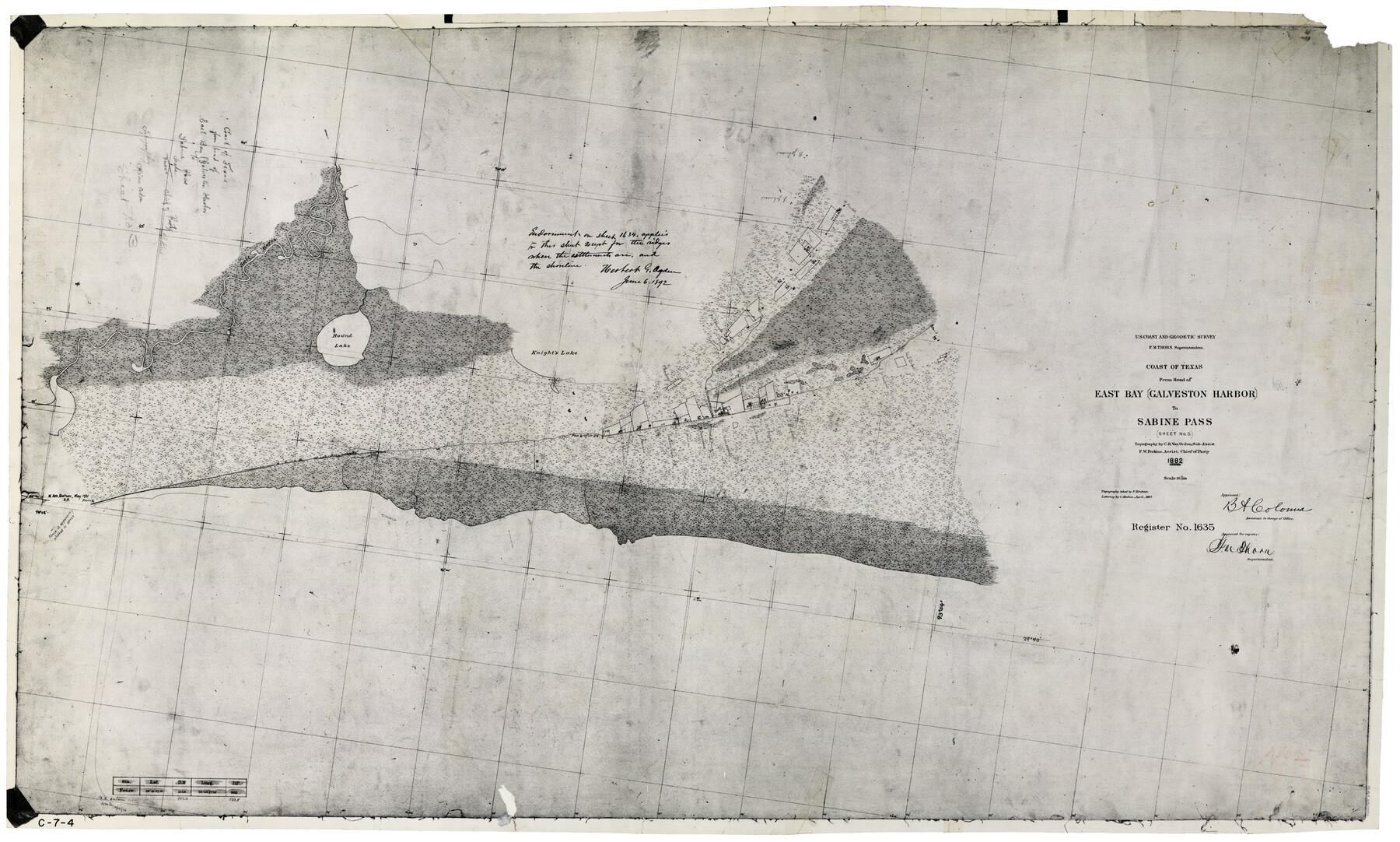
Coast of Texas from head of East Bay Galveston Harbor to Sabine Pass
C-7-4
-
Map/Doc
69840
-
Collection
General Map Collection
-
Object Dates
1882 (Creation Date)
-
Counties
Jefferson Galveston
-
Subjects
Nautical Charts
-
Height x Width
32.3 x 53.9 inches
82.0 x 136.9 cm
-
Comments
Register No. 1633, 1634 and 1635
Part of: General Map Collection
Edwards County Sketch File 30

Print $10.00
- Digital $50.00
Edwards County Sketch File 30
1920
Size 6.5 x 8.9 inches
Map/Doc 21757
Flight Mission No. BRA-3M, Frame 195, Jefferson County

Print $20.00
- Digital $50.00
Flight Mission No. BRA-3M, Frame 195, Jefferson County
1953
Size 18.6 x 22.3 inches
Map/Doc 85410
Live Oak County Working Sketch 39

Print $40.00
- Digital $50.00
Live Oak County Working Sketch 39
2006
Size 36.4 x 48.6 inches
Map/Doc 94156
Pecos County Sketch File 116

Print $6.00
- Digital $50.00
Pecos County Sketch File 116
1913
Size 10.9 x 8.8 inches
Map/Doc 34092
Nueces County Rolled Sketch 71

Print $247.00
Nueces County Rolled Sketch 71
1980
Size 37.9 x 24.7 inches
Map/Doc 6924
Kerr County Working Sketch 28

Print $20.00
- Digital $50.00
Kerr County Working Sketch 28
1971
Size 38.5 x 39.1 inches
Map/Doc 70059
Hutchinson County Rolled Sketch 44-5

Print $20.00
- Digital $50.00
Hutchinson County Rolled Sketch 44-5
2002
Size 24.0 x 36.0 inches
Map/Doc 77541
Bosque County Sketch File 3

Print $40.00
- Digital $50.00
Bosque County Sketch File 3
1848
Size 16.1 x 12.4 inches
Map/Doc 14742
Fractional Township No. 8 South Range No. 1 West of the Indian Meridian, Indian Territory

Print $20.00
- Digital $50.00
Fractional Township No. 8 South Range No. 1 West of the Indian Meridian, Indian Territory
1898
Size 19.2 x 24.4 inches
Map/Doc 75198
Val Verde County Sketch File A3

Print $20.00
- Digital $50.00
Val Verde County Sketch File A3
1917
Size 25.6 x 42.3 inches
Map/Doc 10418
New Map of that portion of North America, exhibiting the United States and Territories, the Canadas, New Brunswick, Nova Scotia and Mexico, also Central America and the West India Islands compiled from the most recent surveys and authentic sources

Print $40.00
- Digital $50.00
New Map of that portion of North America, exhibiting the United States and Territories, the Canadas, New Brunswick, Nova Scotia and Mexico, also Central America and the West India Islands compiled from the most recent surveys and authentic sources
1854
Size 59.4 x 63.0 inches
Map/Doc 93968
Wharton County Working Sketch 16

Print $20.00
- Digital $50.00
Wharton County Working Sketch 16
1952
Size 23.8 x 26.8 inches
Map/Doc 72480
You may also like
J.K Gill & Cos Map of Oregon

Print $20.00
- Digital $50.00
J.K Gill & Cos Map of Oregon
1882
Size 29.0 x 32.3 inches
Map/Doc 94055
Plat of a survey on Padre Island in Willacy County surveyed for South Padre Development Corporation by Claunch and Associates

Print $40.00
- Digital $50.00
Plat of a survey on Padre Island in Willacy County surveyed for South Padre Development Corporation by Claunch and Associates
1973
Size 73.7 x 42.8 inches
Map/Doc 61426
Uvalde County Rolled Sketch 21

Print $40.00
- Digital $50.00
Uvalde County Rolled Sketch 21
Size 54.1 x 45.6 inches
Map/Doc 10067
The Judicial District/County of Burnet. Boundaries Redefined, December 6, 1841

Print $20.00
The Judicial District/County of Burnet. Boundaries Redefined, December 6, 1841
2020
Size 19.2 x 21.6 inches
Map/Doc 96323
Calhoun County Working Sketch 4

Print $20.00
- Digital $50.00
Calhoun County Working Sketch 4
1926
Size 29.2 x 42.2 inches
Map/Doc 67820
Map showing lines of march and border patrols, in my Mexican Border Service, 1916-1917

Print $20.00
- Digital $50.00
Map showing lines of march and border patrols, in my Mexican Border Service, 1916-1917
1916
Size 18.7 x 41.7 inches
Map/Doc 95822
Brewster County Sketch File FN-32

Print $8.00
- Digital $50.00
Brewster County Sketch File FN-32
Size 11.1 x 8.7 inches
Map/Doc 15854
[Part of Hutchison County]
![91144, [Part of Hutchison County], Twichell Survey Records](https://historictexasmaps.com/wmedia_w700/maps/91144-1.tif.jpg)
Print $2.00
- Digital $50.00
[Part of Hutchison County]
1875
Size 7.5 x 11.5 inches
Map/Doc 91144
Pecos County Rolled Sketch 79

Print $20.00
- Digital $50.00
Pecos County Rolled Sketch 79
1930
Size 28.5 x 32.6 inches
Map/Doc 7239
Kent County Boundary File 9

Print $8.00
- Digital $50.00
Kent County Boundary File 9
Size 14.1 x 8.8 inches
Map/Doc 55883
Flight Mission No. BRA-16M, Frame 106, Jefferson County

Print $20.00
- Digital $50.00
Flight Mission No. BRA-16M, Frame 106, Jefferson County
1953
Size 18.6 x 22.3 inches
Map/Doc 85718
Map of Location and Right of Way from El Paso, Tex. To New Mexico Line, Rio Grande & El Paso R.R.

Print $20.00
- Digital $50.00
Map of Location and Right of Way from El Paso, Tex. To New Mexico Line, Rio Grande & El Paso R.R.
Size 14.0 x 20.9 inches
Map/Doc 64085