Current Miscellaneous File 86
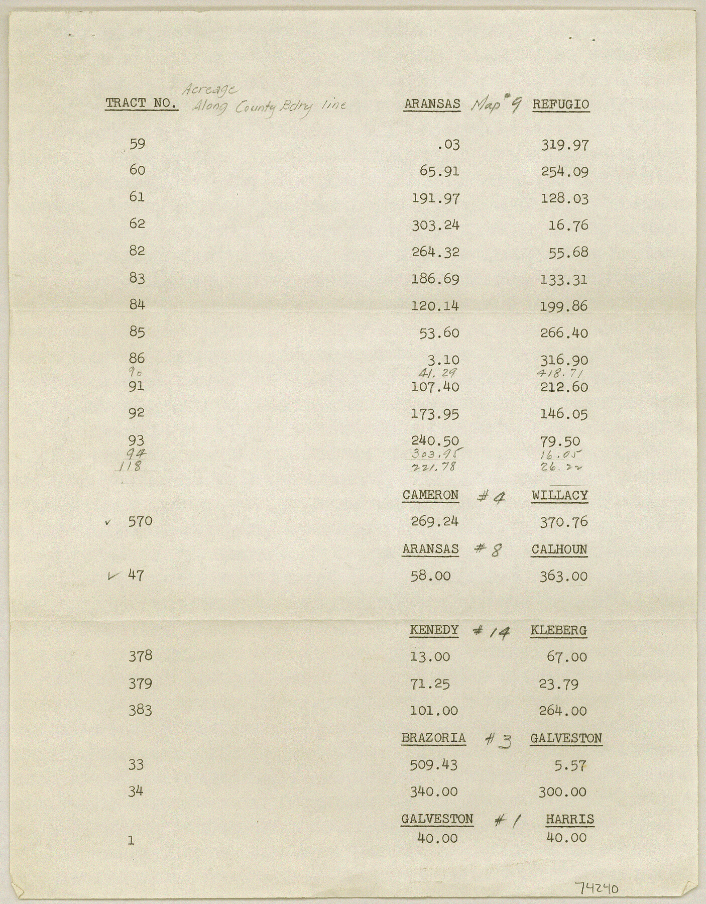
Acreage along county boundary lines. Aransas-Refugio, Cameron-Willacy, Aransas-Calhoun, Kenedy-Kleberg, Brazoria-Galveston, Galveston-Harris
-
Map/Doc
74240
-
Collection
General Map Collection
-
Object Dates
1960/8/10 (File Date)
-
Subjects
County Boundaries
-
Height x Width
11.2 x 8.8 inches
28.5 x 22.4 cm
Part of: General Map Collection
Burleson County

Print $20.00
- Digital $50.00
Burleson County
1920
Size 40.7 x 45.2 inches
Map/Doc 66740
Willacy County Aerial Photograph Index Sheet 5

Print $20.00
- Digital $50.00
Willacy County Aerial Photograph Index Sheet 5
1940
Size 20.1 x 24.4 inches
Map/Doc 83758
Culberson County Working Sketch 25

Print $40.00
- Digital $50.00
Culberson County Working Sketch 25
1951
Size 30.5 x 52.9 inches
Map/Doc 68478
Zavala County

Print $40.00
- Digital $50.00
Zavala County
1977
Size 43.6 x 49.3 inches
Map/Doc 95684
Intracoastal Waterway in Texas - Corpus Christi to Point Isabel including Arroyo Colorado to Mo. Pac. R.R. Bridge Near Harlingen

Print $20.00
- Digital $50.00
Intracoastal Waterway in Texas - Corpus Christi to Point Isabel including Arroyo Colorado to Mo. Pac. R.R. Bridge Near Harlingen
1933
Size 28.1 x 41.4 inches
Map/Doc 61871
Angelina County Sketch File 15d

Print $20.00
- Digital $50.00
Angelina County Sketch File 15d
1863
Size 8.0 x 6.6 inches
Map/Doc 12980
Parker County Sketch File 15A

Print $20.00
- Digital $50.00
Parker County Sketch File 15A
1875
Size 28.5 x 13.6 inches
Map/Doc 12144
Kendall County Sketch File 17

Print $4.00
- Digital $50.00
Kendall County Sketch File 17
1878
Size 9.1 x 7.6 inches
Map/Doc 28709

Eastland County Rolled Sketch 14

Print $20.00
- Digital $50.00
Eastland County Rolled Sketch 14
Size 18.5 x 18.3 inches
Map/Doc 5775
In the Supreme Court of the United States, The State of Oklahoma, Complainant vs. The State of Texas, Defendant, The United States of America, Intervener, Red River Valley, Texas and Oklahoma Between the 98th and 100th Meridians in Five Sheets, 1921

Print $40.00
- Digital $50.00
In the Supreme Court of the United States, The State of Oklahoma, Complainant vs. The State of Texas, Defendant, The United States of America, Intervener, Red River Valley, Texas and Oklahoma Between the 98th and 100th Meridians in Five Sheets, 1921
Size 38.3 x 60.1 inches
Map/Doc 75279
Flight Mission No. DQN-2K, Frame 138, Calhoun County

Print $20.00
- Digital $50.00
Flight Mission No. DQN-2K, Frame 138, Calhoun County
1953
Size 16.1 x 16.0 inches
Map/Doc 84307
You may also like
Morris County Rolled Sketch 2A

Print $3.00
- Digital $50.00
Morris County Rolled Sketch 2A
Size 12.1 x 10.5 inches
Map/Doc 10233
Stephens County Working Sketch 24

Print $20.00
- Digital $50.00
Stephens County Working Sketch 24
1976
Size 39.2 x 31.9 inches
Map/Doc 63967
Bandera County Working Sketch 48

Print $20.00
- Digital $50.00
Bandera County Working Sketch 48
1981
Size 21.0 x 21.6 inches
Map/Doc 67644
Castro County Sketch File 17

Print $20.00
- Digital $50.00
Castro County Sketch File 17
1981
Size 14.8 x 25.7 inches
Map/Doc 11063
George M. Slaughter Block Hockley and Cochran Counties, Texas

Print $20.00
- Digital $50.00
George M. Slaughter Block Hockley and Cochran Counties, Texas
1929
Size 14.1 x 25.2 inches
Map/Doc 92238
Zavala Empresario Colony. March 12, 1829

Print $20.00
Zavala Empresario Colony. March 12, 1829
2020
Size 24.7 x 21.7 inches
Map/Doc 96012
Bexar County Sketch File 34

Print $23.00
- Digital $50.00
Bexar County Sketch File 34
1872
Size 12.2 x 12.5 inches
Map/Doc 14498
Brewster County Rolled Sketch 101

Print $40.00
- Digital $50.00
Brewster County Rolled Sketch 101
1927
Size 73.5 x 42.3 inches
Map/Doc 9194
Mills County Rolled Sketch 4

Print $20.00
- Digital $50.00
Mills County Rolled Sketch 4
2000
Size 26.6 x 21.6 inches
Map/Doc 6782
Culberson County Rolled Sketch 23

Print $20.00
- Digital $50.00
Culberson County Rolled Sketch 23
1888
Size 24.1 x 35.2 inches
Map/Doc 5655
Montgomery County Working Sketch 10

Print $20.00
- Digital $50.00
Montgomery County Working Sketch 10
1933
Size 36.5 x 38.6 inches
Map/Doc 71117
Mapa Geográphico de la Provincia de Tejas

Mapa Geográphico de la Provincia de Tejas
1822
Size 9.8 x 12.7 inches
Map/Doc 94457