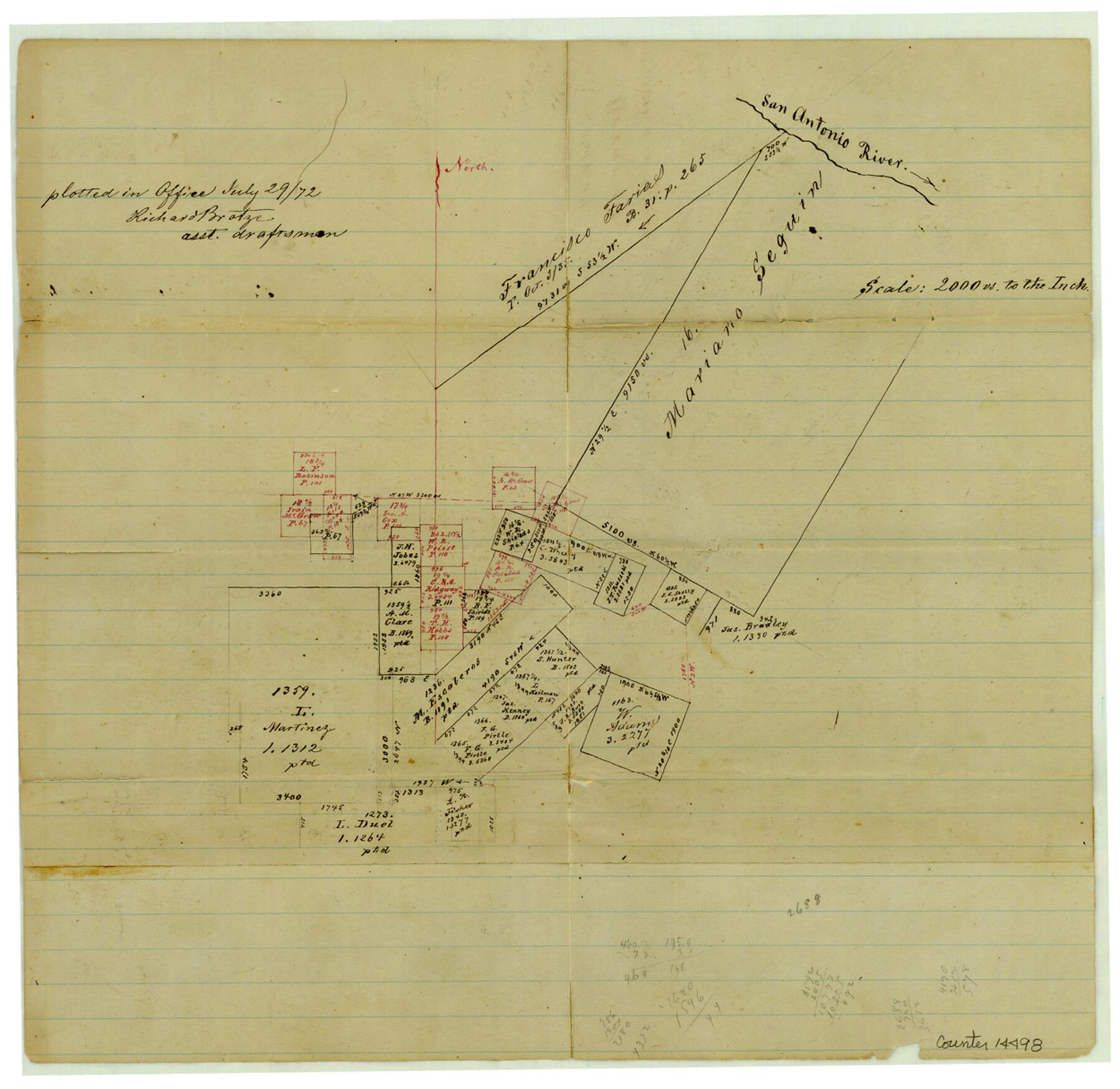
Bexar County Sketch File 34
[Sketch of area in the southeast corner of Bexar County]
-
Map/Doc
14498
-
Collection
General Map Collection
-
Object Dates
1872/7/29 (Creation Date)
1872/7/30 (File Date)
-
People and Organizations
Richard Brotze (Draftsman)
-
Counties
Bexar
-
Subjects
Surveying Sketch File
-
Height x Width
12.2 x 12.5 inches
31.0 x 31.8 cm
-
Medium
paper, manuscript
-
Scale
1" = 2000 varas
-
Features
San Antonio River
Part of: General Map Collection
United States - Gulf Coast Texas - Southern part of Laguna Madre

Print $20.00
- Digital $50.00
United States - Gulf Coast Texas - Southern part of Laguna Madre
1933
Size 26.6 x 18.3 inches
Map/Doc 72951
Real County Working Sketch 86

Print $20.00
- Digital $50.00
Real County Working Sketch 86
1988
Size 37.8 x 26.6 inches
Map/Doc 71978
Kerr County Sketch File 17

Print $20.00
- Digital $50.00
Kerr County Sketch File 17
1950
Size 23.3 x 23.8 inches
Map/Doc 11920
Map of Gonzales County

Print $40.00
- Digital $50.00
Map of Gonzales County
1842
Size 59.5 x 50.0 inches
Map/Doc 16839
El Paso County Rolled Sketch 33

Print $42.00
- Digital $50.00
El Paso County Rolled Sketch 33
Size 35.1 x 25.6 inches
Map/Doc 8867
Motley County Sketch File 5 (S)

Print $20.00
- Digital $50.00
Motley County Sketch File 5 (S)
Size 20.5 x 19.4 inches
Map/Doc 42138
Dry Fork of Brushy Creek

Print $2.00
- Digital $50.00
Dry Fork of Brushy Creek
Size 7.1 x 6.8 inches
Map/Doc 78380
Kimble County Working Sketch 1

Print $20.00
- Digital $50.00
Kimble County Working Sketch 1
Size 14.7 x 18.3 inches
Map/Doc 70069
Val Verde County Working Sketch 48

Print $20.00
- Digital $50.00
Val Verde County Working Sketch 48
1949
Size 32.6 x 17.6 inches
Map/Doc 72183
Karnes County Rolled Sketch 2

Print $20.00
- Digital $50.00
Karnes County Rolled Sketch 2
1957
Size 35.3 x 30.0 inches
Map/Doc 6453
Tyler County Sketch File 1b

Print $8.00
- Digital $50.00
Tyler County Sketch File 1b
1900
Size 7.5 x 3.2 inches
Map/Doc 38611
Cooke County Sketch File 19

Print $8.00
- Digital $50.00
Cooke County Sketch File 19
1861
Size 7.9 x 6.1 inches
Map/Doc 19260
You may also like
Texas, Corpus Christi, Corpus Christi to Laguna Madre

Print $40.00
- Digital $50.00
Texas, Corpus Christi, Corpus Christi to Laguna Madre
1934
Size 35.1 x 48.6 inches
Map/Doc 73457
Terrell County Sketch File 18

Print $8.00
- Digital $50.00
Terrell County Sketch File 18
1908
Size 9.1 x 4.4 inches
Map/Doc 37941
Sabine County Sketch File 3

Print $2.00
Sabine County Sketch File 3
1874
Size 12.7 x 8.0 inches
Map/Doc 35604
Terrell County Sketch File 9

Print $12.00
- Digital $50.00
Terrell County Sketch File 9
Size 9.8 x 8.5 inches
Map/Doc 37904
Travis County Appraisal District Plat Map 3_0404

Print $20.00
- Digital $50.00
Travis County Appraisal District Plat Map 3_0404
Size 21.5 x 26.4 inches
Map/Doc 94226
Harris County Working Sketch 67

Print $20.00
- Digital $50.00
Harris County Working Sketch 67
1955
Size 23.3 x 27.5 inches
Map/Doc 65959
Refugio County Rolled Sketch 7

Print $20.00
- Digital $50.00
Refugio County Rolled Sketch 7
1946
Size 28.4 x 34.5 inches
Map/Doc 7508
Lubbock County Rolled Sketch 5

Print $20.00
- Digital $50.00
Lubbock County Rolled Sketch 5
Size 19.8 x 14.2 inches
Map/Doc 6641
Presidio County Working Sketch 79

Print $40.00
- Digital $50.00
Presidio County Working Sketch 79
1966
Size 42.4 x 50.5 inches
Map/Doc 71756
Moore County Sketch File 5

Print $22.00
- Digital $50.00
Moore County Sketch File 5
Size 9.0 x 12.6 inches
Map/Doc 31937
Johnson County Sketch File 26

Print $28.00
- Digital $50.00
Johnson County Sketch File 26
1892
Size 14.3 x 8.8 inches
Map/Doc 28474
Republic Counties. January 1, 1843

Print $20.00
Republic Counties. January 1, 1843
2020
Size 24.5 x 21.7 inches
Map/Doc 96316