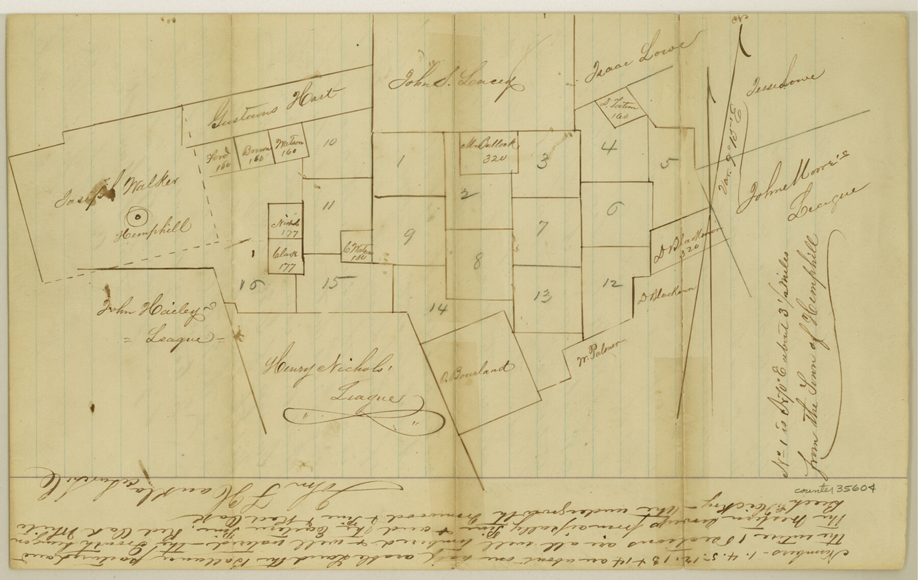
Sabine County Sketch File 3
[Sketch of surveys southeast from Hemphill]
-
Map/Doc
35604
-
Collection
General Map Collection
-
Object Dates
11/23/1874 (Creation Date)
11/23/1874 (File Date)
-
People and Organizations
John F. Hankla (Surveyor/Engineer)
-
Counties
Sabine
-
Subjects
Surveying Sketch File
-
Height x Width
12.7 x 8.0 inches
32.3 x 20.3 cm
-
Medium
paper, manuscript
-
Features
Hemphill
Part of: General Map Collection
Motley County Sketch File 16 (N)

Print $16.00
- Digital $50.00
Motley County Sketch File 16 (N)
1911
Size 11.0 x 8.6 inches
Map/Doc 32052
Controlled Mosaic by Jack Amman Photogrammetric Engineers, Inc - Sheet 4

Print $20.00
- Digital $50.00
Controlled Mosaic by Jack Amman Photogrammetric Engineers, Inc - Sheet 4
1954
Size 20.0 x 24.0 inches
Map/Doc 83448
H No. 2 - Preliminary Sketch of Mobile Bay

Print $20.00
- Digital $50.00
H No. 2 - Preliminary Sketch of Mobile Bay
1852
Size 19.4 x 15.2 inches
Map/Doc 97223
Jasper County Sketch File 15

Print $6.00
- Digital $50.00
Jasper County Sketch File 15
Size 9.9 x 15.3 inches
Map/Doc 27806
Blanco County Sketch File 47

Print $46.00
- Digital $50.00
Blanco County Sketch File 47
Size 14.4 x 8.7 inches
Map/Doc 14675
Ellis County Sketch File 11

Print $40.00
- Digital $50.00
Ellis County Sketch File 11
1860
Size 12.6 x 16.2 inches
Map/Doc 21847
Trinity County Working Sketch 9

Print $20.00
- Digital $50.00
Trinity County Working Sketch 9
1947
Size 23.5 x 28.1 inches
Map/Doc 69458
Ellis County Boundary File 3

Print $58.00
- Digital $50.00
Ellis County Boundary File 3
Size 14.1 x 122.4 inches
Map/Doc 52950
Jasper County Working Sketch 26

Print $20.00
- Digital $50.00
Jasper County Working Sketch 26
1953
Size 23.1 x 18.1 inches
Map/Doc 66488
Fractional Township No. 8 South Range No. 23 East of the Indian Meridian, Indian Territory

Print $20.00
- Digital $50.00
Fractional Township No. 8 South Range No. 23 East of the Indian Meridian, Indian Territory
1898
Size 19.1 x 24.3 inches
Map/Doc 75249
Falls County Working Sketch Graphic Index

Print $20.00
- Digital $50.00
Falls County Working Sketch Graphic Index
1976
Size 39.7 x 44.2 inches
Map/Doc 76539
Flight Mission No. DIX-8P, Frame 66, Aransas County

Print $20.00
- Digital $50.00
Flight Mission No. DIX-8P, Frame 66, Aransas County
1956
Size 18.6 x 22.2 inches
Map/Doc 83897
You may also like
Flight Mission No. BRA-3M, Frame 195, Jefferson County

Print $20.00
- Digital $50.00
Flight Mission No. BRA-3M, Frame 195, Jefferson County
1953
Size 18.6 x 22.3 inches
Map/Doc 85410
Liberty County Sketch File 27

Print $5.00
- Digital $50.00
Liberty County Sketch File 27
Size 11.5 x 9.3 inches
Map/Doc 29948
Gregg County Working Sketch 21

Print $20.00
- Digital $50.00
Gregg County Working Sketch 21
1966
Size 25.5 x 32.1 inches
Map/Doc 63288
Reagan County Rolled Sketch 16

Print $20.00
- Digital $50.00
Reagan County Rolled Sketch 16
Size 25.6 x 47.5 inches
Map/Doc 9811
San Patricio County Rolled Sketch BB

Print $40.00
- Digital $50.00
San Patricio County Rolled Sketch BB
1936
Size 25.0 x 49.0 inches
Map/Doc 9889
Garza County Sketch File F

Print $20.00
- Digital $50.00
Garza County Sketch File F
Size 9.8 x 18.9 inches
Map/Doc 11553
Hydograhic Survey H-994, Corpus Christi Pass

Print $40.00
- Digital $50.00
Hydograhic Survey H-994, Corpus Christi Pass
1869
Size 31.8 x 53.7 inches
Map/Doc 2701
Grayson County Boundary File 1a

Print $120.00
- Digital $50.00
Grayson County Boundary File 1a
Size 69.3 x 11.3 inches
Map/Doc 53928
Donley County Sketch File 3

Print $6.00
- Digital $50.00
Donley County Sketch File 3
Size 10.8 x 11.9 inches
Map/Doc 21217
McLennan County Sketch File 1b

Print $4.00
- Digital $50.00
McLennan County Sketch File 1b
Size 8.3 x 8.1 inches
Map/Doc 31228
National Map Company's New Road Survey of the United States Showing Main Highways

Digital $50.00
National Map Company's New Road Survey of the United States Showing Main Highways
Size 44.5 x 38.2 inches
Map/Doc 4659
Hockley County Rolled Sketch 5

Print $40.00
- Digital $50.00
Hockley County Rolled Sketch 5
Size 80.8 x 29.5 inches
Map/Doc 9175