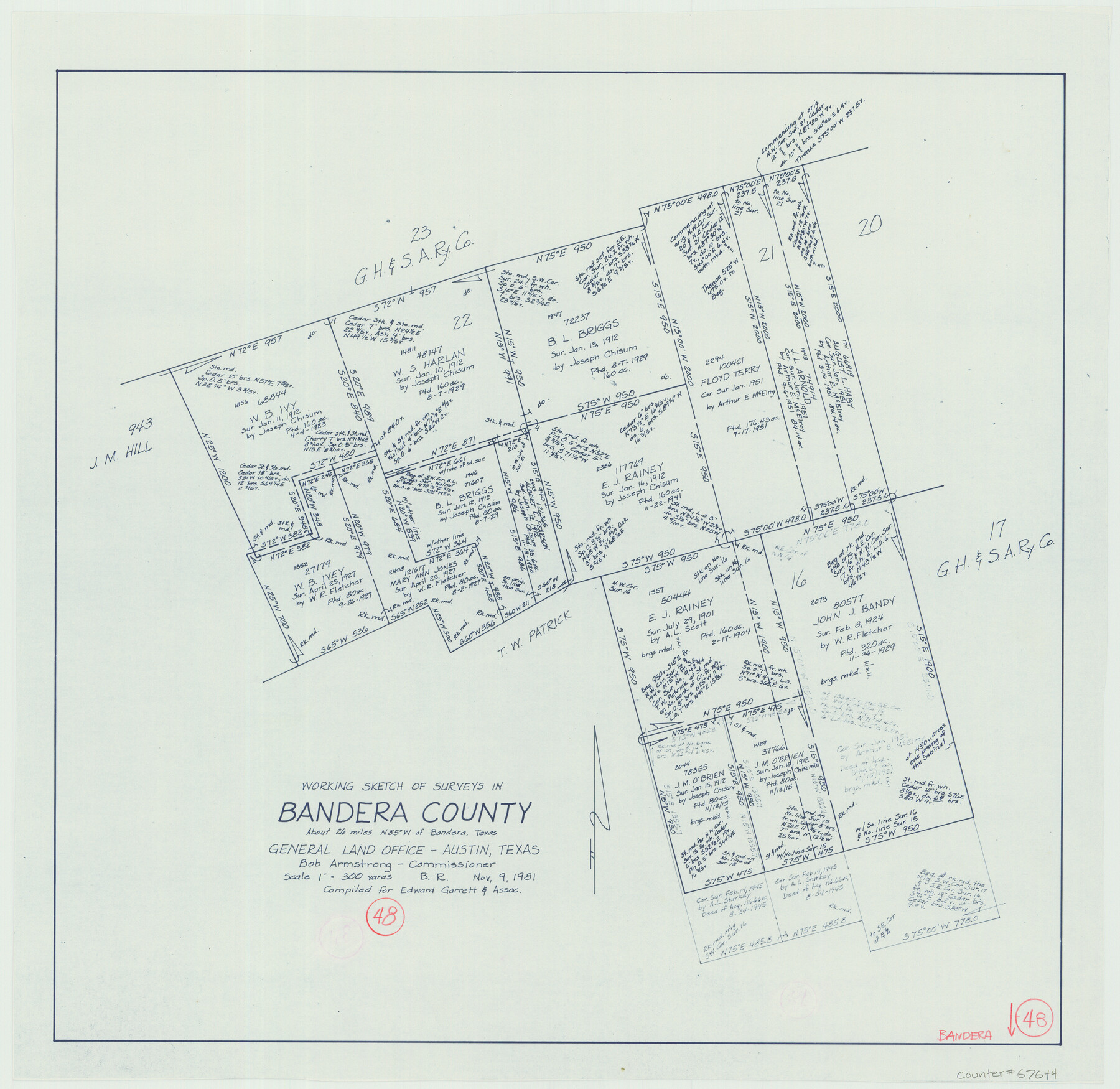
Bandera County Working Sketch 48
-
Map/Doc
67644
-
Collection
General Map Collection
-
Object Dates
11/9/1981 (Creation Date)
-
People and Organizations
Bob Armstrong (GLO Commissioner)
Beverly Robison (Draftsman)
-
Counties
Bandera
-
Subjects
Surveying Working Sketch
-
Height x Width
21.0 x 21.6 inches
53.3 x 54.9 cm
-
Scale
1" = 300 varas
-
Comments
Surveys located about 26 miles North 85 degrees West of Bandera, Texas.
Part of: General Map Collection
Webb County Working Sketch 89

Print $20.00
- Digital $50.00
Webb County Working Sketch 89
1982
Size 44.6 x 43.0 inches
Map/Doc 72456
Milam County Working Sketch 10

Print $20.00
- Digital $50.00
Milam County Working Sketch 10
1986
Size 25.5 x 34.6 inches
Map/Doc 71025
Presidio County Rolled Sketch 62

Print $20.00
- Digital $50.00
Presidio County Rolled Sketch 62
1916
Size 39.5 x 21.7 inches
Map/Doc 78468
[San Antonio & Aransas Pass]
![64209, [San Antonio & Aransas Pass], General Map Collection](https://historictexasmaps.com/wmedia_w700/maps/64209.tif.jpg)
Print $20.00
- Digital $50.00
[San Antonio & Aransas Pass]
Size 15.2 x 45.5 inches
Map/Doc 64209
Motley County Sketch File 24 (S)

Print $4.00
- Digital $50.00
Motley County Sketch File 24 (S)
Size 9.2 x 7.1 inches
Map/Doc 32204
Motley County Sketch File 33 (S)

Print $6.00
- Digital $50.00
Motley County Sketch File 33 (S)
1914
Size 7.4 x 8.5 inches
Map/Doc 32217
Terry County Working Sketch 2

Print $20.00
- Digital $50.00
Terry County Working Sketch 2
1952
Size 19.3 x 19.3 inches
Map/Doc 62107
Flight Mission No. DCL-6C, Frame 94, Kenedy County

Print $20.00
- Digital $50.00
Flight Mission No. DCL-6C, Frame 94, Kenedy County
1943
Size 18.6 x 22.3 inches
Map/Doc 85924
Dimmit County Working Sketch 53

Print $20.00
- Digital $50.00
Dimmit County Working Sketch 53
1990
Size 25.5 x 26.0 inches
Map/Doc 68714
Harris County Rolled Sketch 85

Print $20.00
- Digital $50.00
Harris County Rolled Sketch 85
1968
Size 22.0 x 32.0 inches
Map/Doc 6119
El Paso County Rolled Sketch 40

Print $20.00
- Digital $50.00
El Paso County Rolled Sketch 40
1930
Size 11.6 x 16.8 inches
Map/Doc 5826
Map of the 1st, 2nd and 3rd Sections of Houston & Texas Central Railroad

Print $40.00
- Digital $50.00
Map of the 1st, 2nd and 3rd Sections of Houston & Texas Central Railroad
Size 30.7 x 64.6 inches
Map/Doc 64478
You may also like
Kerr County Sketch File 4

Print $10.00
- Digital $50.00
Kerr County Sketch File 4
1873
Size 8.1 x 7.7 inches
Map/Doc 28860
Yellowhouse Addition to Littlefield, Texas Located on Labors 12 & 13 Capitol League 664

Print $20.00
- Digital $50.00
Yellowhouse Addition to Littlefield, Texas Located on Labors 12 & 13 Capitol League 664
1925
Size 26.9 x 26.7 inches
Map/Doc 92402
Atascosa County

Print $20.00
- Digital $50.00
Atascosa County
1948
Size 46.6 x 45.4 inches
Map/Doc 73072
Garden City Townsite, Section 5, Range 4 South, Block 33

Print $2.00
- Digital $50.00
Garden City Townsite, Section 5, Range 4 South, Block 33
1886
Size 9.0 x 15.4 inches
Map/Doc 90761
Calhoun County NRC Article 33.136 Sketch 14

Print $24.00
Calhoun County NRC Article 33.136 Sketch 14
2023
Map/Doc 97273
No. 1 - Survey for a road from the Brazo Santiago to the Rio Grande

Print $20.00
- Digital $50.00
No. 1 - Survey for a road from the Brazo Santiago to the Rio Grande
1847
Size 18.3 x 27.2 inches
Map/Doc 72874
Concho County Sketch File 35

Print $20.00
- Digital $50.00
Concho County Sketch File 35
1937
Size 14.9 x 15.5 inches
Map/Doc 11160
El Paso County Working Sketch 32

Print $20.00
- Digital $50.00
El Paso County Working Sketch 32
1971
Size 40.2 x 38.3 inches
Map/Doc 69054
Armstrong County Sketch File A-9

Print $40.00
- Digital $50.00
Armstrong County Sketch File A-9
1920
Size 13.7 x 35.4 inches
Map/Doc 10851
Ralls, Crosby County, Texas

Print $20.00
- Digital $50.00
Ralls, Crosby County, Texas
Size 22.5 x 29.8 inches
Map/Doc 92601
Milam County Boundary File 5a

Print $12.00
- Digital $50.00
Milam County Boundary File 5a
Size 14.1 x 8.5 inches
Map/Doc 57233
Loving County Rolled Sketch 12

Print $20.00
- Digital $50.00
Loving County Rolled Sketch 12
Size 35.5 x 42.6 inches
Map/Doc 76418