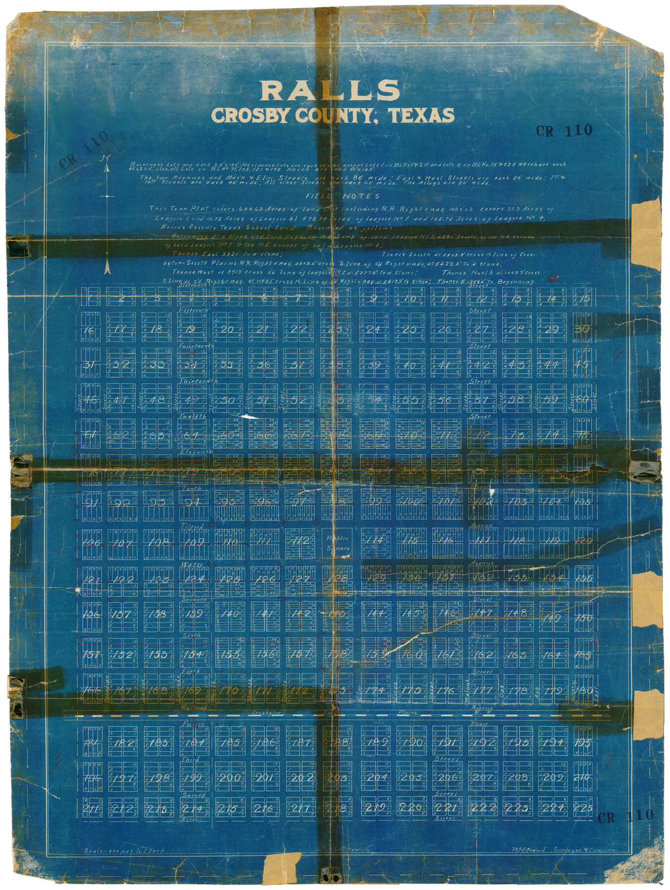
Ralls, Crosby County, Texas
CR110
-
Map/Doc
92601
-
Collection
Twichell Survey Records
-
People and Organizations
W.H. Orand (Draftsman)
W.H. Orand (Surveyor/Engineer)
-
Counties
Crosby
-
Height x Width
22.5 x 29.8 inches
57.2 x 75.7 cm
Part of: Twichell Survey Records
Green & Lumsden's Ranch

Print $20.00
- Digital $50.00
Green & Lumsden's Ranch
Size 28.9 x 25.1 inches
Map/Doc 92946
Ownership Map of Lynn County

Print $20.00
- Digital $50.00
Ownership Map of Lynn County
Size 34.5 x 36.1 inches
Map/Doc 92900
[Sketch showing west part of county]
![91712, [Sketch showing west part of county], Twichell Survey Records](https://historictexasmaps.com/wmedia_w700/maps/91712-1.tif.jpg)
Print $3.00
- Digital $50.00
[Sketch showing west part of county]
1907
Size 16.4 x 11.1 inches
Map/Doc 91712
Lubbock County Hale County

Print $20.00
- Digital $50.00
Lubbock County Hale County
Size 18.0 x 22.4 inches
Map/Doc 92833
[Blocks 1 and H]
![90719, [Blocks 1 and H], Twichell Survey Records](https://historictexasmaps.com/wmedia_w700/maps/90719-1.tif.jpg)
Print $20.00
- Digital $50.00
[Blocks 1 and H]
Size 27.1 x 21.6 inches
Map/Doc 90719
Map of the Survey of the 100th Meridian of Longitude west of Greenwich beginning at Red River and extending to the parallel 36 1/2 degrees north latitude

Print $40.00
- Digital $50.00
Map of the Survey of the 100th Meridian of Longitude west of Greenwich beginning at Red River and extending to the parallel 36 1/2 degrees north latitude
Size 11.4 x 111.7 inches
Map/Doc 93191

[Leagues 391, 391 1/2 and part of Block K7]
![90534, [Leagues 391, 391 1/2 and part of Block K7], Twichell Survey Records](https://historictexasmaps.com/wmedia_w700/maps/90534-1.tif.jpg)
Print $2.00
- Digital $50.00
[Leagues 391, 391 1/2 and part of Block K7]
1902
Size 4.7 x 6.3 inches
Map/Doc 90534
Sketch of 103rd Meridian, W. L. showing Conflict of Capitol Leagues

Print $20.00
- Digital $50.00
Sketch of 103rd Meridian, W. L. showing Conflict of Capitol Leagues
Size 8.1 x 22.1 inches
Map/Doc 90578
[PSL Block B1 and T. & P. Blocks 45 and 46, Township 1N]
![91967, [PSL Block B1 and T. & P. Blocks 45 and 46, Township 1N], Twichell Survey Records](https://historictexasmaps.com/wmedia_w700/maps/91967-1.tif.jpg)
Print $20.00
- Digital $50.00
[PSL Block B1 and T. & P. Blocks 45 and 46, Township 1N]
Size 40.8 x 10.6 inches
Map/Doc 91967
Map of T. C. Ivey's Ranch Block D - John H. Gibson

Print $20.00
- Digital $50.00
Map of T. C. Ivey's Ranch Block D - John H. Gibson
Size 13.9 x 14.0 inches
Map/Doc 92853
Yoakum County, Texas

Print $20.00
- Digital $50.00
Yoakum County, Texas
1936
Size 38.4 x 43.5 inches
Map/Doc 89903
You may also like
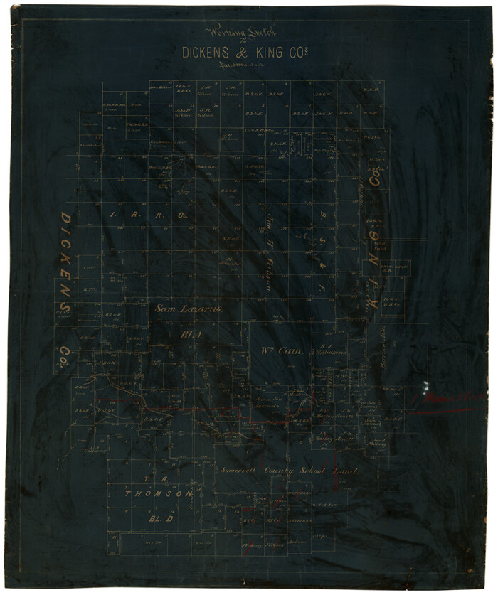
Working Sketch in Dickens & King Cos.
Print $20.00
- Digital $50.00
Working Sketch in Dickens & King Cos.
Size 24.4 x 20.4 inches
Map/Doc 10770

[Capitol Leagues 217-228, 238, and vicinity]
![90674, [Capitol Leagues 217-228, 238, and vicinity], Twichell Survey Records](https://historictexasmaps.com/wmedia_w700/maps/90674-1.tif.jpg)
Print $20.00
- Digital $50.00
[Capitol Leagues 217-228, 238, and vicinity]
Size 22.8 x 10.0 inches
Map/Doc 90674
Hunt County Sketch File 49

Print $4.00
- Digital $50.00
Hunt County Sketch File 49
1852
Size 7.3 x 8.9 inches
Map/Doc 27168
Harrison County Working Sketch 33

Print $20.00
- Digital $50.00
Harrison County Working Sketch 33
2015
Size 19.8 x 22.8 inches
Map/Doc 93725
Bexar County Sketch File 11

Print $2.00
- Digital $50.00
Bexar County Sketch File 11
Size 8.3 x 9.5 inches
Map/Doc 14481
Plan of the City of Galveston, Texas

Print $20.00
- Digital $50.00
Plan of the City of Galveston, Texas
1845
Size 19.3 x 41.8 inches
Map/Doc 4665
Clay County Sketch File 39

Print $10.00
- Digital $50.00
Clay County Sketch File 39
1940
Size 14.3 x 8.7 inches
Map/Doc 18472
Flight Mission No. BQR-22K, Frame 42, Brazoria County

Print $20.00
- Digital $50.00
Flight Mission No. BQR-22K, Frame 42, Brazoria County
1953
Size 18.9 x 22.7 inches
Map/Doc 84126
The Republic County of Austin. December 29, 1845

Print $20.00
The Republic County of Austin. December 29, 1845
2020
Size 14.7 x 21.6 inches
Map/Doc 96088
Map of the Reconnaissance in Texas by Lieuts Blake & Meade of the Corps of Topl. Engrs.

Print $20.00
- Digital $50.00
Map of the Reconnaissance in Texas by Lieuts Blake & Meade of the Corps of Topl. Engrs.
1845
Size 27.6 x 18.2 inches
Map/Doc 72891
Medina County Rolled Sketch 13

Print $20.00
- Digital $50.00
Medina County Rolled Sketch 13
1979
Size 28.2 x 18.3 inches
Map/Doc 6747