Brewster County Sketch File FN-33
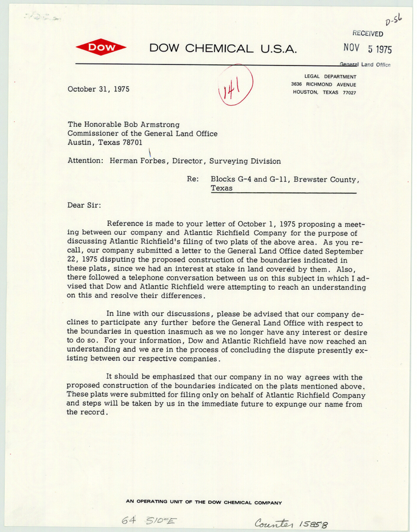
[Letter from Dow Chemical removing protest regarding C.C. Cool survey of Blocks G-4 and G-11]
-
Map/Doc
15858
-
Collection
General Map Collection
-
Object Dates
1975/10/31 (Creation Date)
1975/11/5 (File Date)
-
People and Organizations
C.C. Cool (Surveyor/Engineer)
Karl R. Nordquist (Author)
-
Counties
Brewster
-
Subjects
Surveying Sketch File
-
Height x Width
11.1 x 8.7 inches
28.2 x 22.1 cm
-
Medium
paper, print
Part of: General Map Collection
Refugio County

Print $20.00
- Digital $50.00
Refugio County
1872
Size 17.6 x 22.9 inches
Map/Doc 3987
Burnet County Boundary File 3

Print $18.00
- Digital $50.00
Burnet County Boundary File 3
Size 12.8 x 8.2 inches
Map/Doc 50863
Flight Mission No. BQR-13K, Frame 122, Brazoria County

Print $20.00
- Digital $50.00
Flight Mission No. BQR-13K, Frame 122, Brazoria County
1952
Size 18.6 x 22.3 inches
Map/Doc 84083
[Sketch for Mineral Application 16787 - Pecos River Bed, A. T. Freet]
![2815, [Sketch for Mineral Application 16787 - Pecos River Bed, A. T. Freet], General Map Collection](https://historictexasmaps.com/wmedia_w700/maps/2815-1.tif.jpg)
Print $20.00
- Digital $50.00
[Sketch for Mineral Application 16787 - Pecos River Bed, A. T. Freet]
1927
Size 20.0 x 46.7 inches
Map/Doc 2815
El Paso County Sketch File 4

Print $20.00
- Digital $50.00
El Paso County Sketch File 4
1885
Size 17.1 x 28.3 inches
Map/Doc 11449
Kimble County

Print $40.00
- Digital $50.00
Kimble County
1930
Size 43.8 x 49.2 inches
Map/Doc 73207
Webb County Working Sketch 11

Print $20.00
- Digital $50.00
Webb County Working Sketch 11
1921
Size 17.8 x 16.3 inches
Map/Doc 72376
Hardin County Working Sketch 38

Print $20.00
- Digital $50.00
Hardin County Working Sketch 38
1981
Size 37.2 x 19.4 inches
Map/Doc 63436
Culberson County Sketch File 3

Print $58.00
- Digital $50.00
Culberson County Sketch File 3
Size 8.0 x 3.3 inches
Map/Doc 20112
Flight Mission No. BRE-1P, Frame 122, Nueces County

Print $20.00
- Digital $50.00
Flight Mission No. BRE-1P, Frame 122, Nueces County
1956
Size 18.7 x 22.7 inches
Map/Doc 86688

Eastland County Working Sketch 53

Print $20.00
- Digital $50.00
Eastland County Working Sketch 53
1982
Size 22.9 x 27.4 inches
Map/Doc 68834
You may also like
[H. & T. C. Block 47 and Vicinity]
![91423, [H. & T. C. Block 47 and Vicinity], Twichell Survey Records](https://historictexasmaps.com/wmedia_w700/maps/91423-1.tif.jpg)
Print $20.00
- Digital $50.00
[H. & T. C. Block 47 and Vicinity]
1887
Size 16.3 x 18.8 inches
Map/Doc 91423
Goliad County Sketch File 15

Print $4.00
- Digital $50.00
Goliad County Sketch File 15
1879
Size 8.1 x 14.9 inches
Map/Doc 24245
Falls County Sketch File 18a

Print $8.00
- Digital $50.00
Falls County Sketch File 18a
Size 13.3 x 9.0 inches
Map/Doc 22382
Guadalupe County Sketch File 1a

Print $4.00
- Digital $50.00
Guadalupe County Sketch File 1a
1859
Size 12.6 x 7.9 inches
Map/Doc 24646
Dickens County

Print $20.00
- Digital $50.00
Dickens County
1915
Size 42.2 x 39.0 inches
Map/Doc 66805
Culberson County Working Sketch 31

Print $20.00
- Digital $50.00
Culberson County Working Sketch 31
1958
Size 30.5 x 30.0 inches
Map/Doc 68484
Flight Mission No. CGI-3N, Frame 136, Cameron County

Print $20.00
- Digital $50.00
Flight Mission No. CGI-3N, Frame 136, Cameron County
1954
Size 18.6 x 22.3 inches
Map/Doc 84609
[H. & G. N. Block 8 showing Llano and Espuella fence lines]
![90374, [H. & G. N. Block 8 showing Llano and Espuella fence lines], Twichell Survey Records](https://historictexasmaps.com/wmedia_w700/maps/90374-1.tif.jpg)
Print $2.00
- Digital $50.00
[H. & G. N. Block 8 showing Llano and Espuella fence lines]
Size 6.2 x 9.7 inches
Map/Doc 90374
Grayson County Boundary File 3

Print $8.00
- Digital $50.00
Grayson County Boundary File 3
Size 12.8 x 7.9 inches
Map/Doc 53941
General Highway Map, Lipscomb County, Texas

Print $20.00
General Highway Map, Lipscomb County, Texas
1961
Size 18.1 x 24.6 inches
Map/Doc 79573
Northeast Part Pecos County

Print $20.00
- Digital $50.00
Northeast Part Pecos County
1975
Size 35.8 x 42.3 inches
Map/Doc 73260
Map of Sutton County

Print $20.00
- Digital $50.00
Map of Sutton County
1887
Size 24.5 x 29.5 inches
Map/Doc 4061