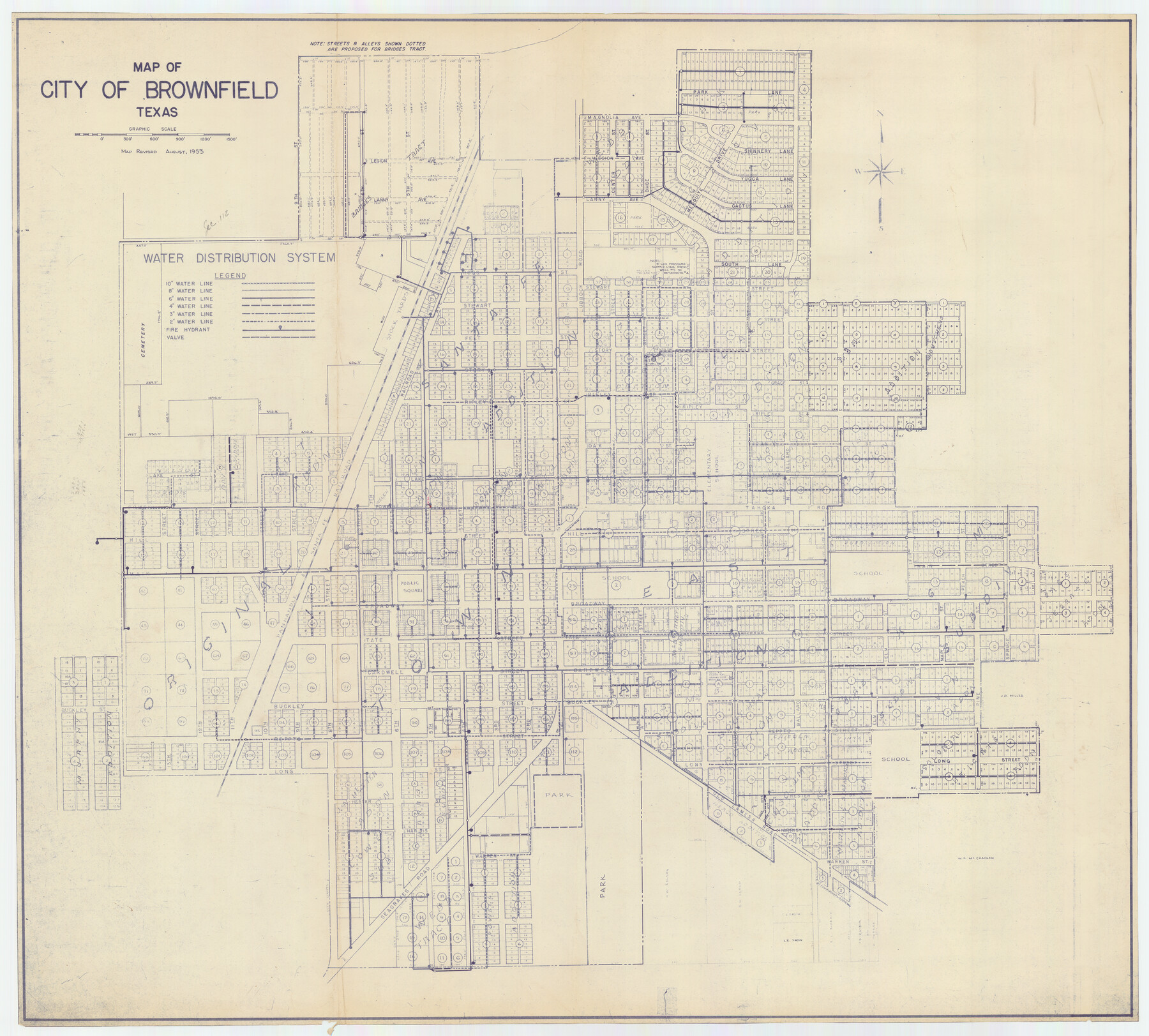
Map of City of Brownfield, Texas
-
Map/Doc
89890
-
Collection
Twichell Survey Records
-
Object Dates
8/1953 (Creation Date)
-
Counties
Terry
-
Height x Width
44.4 x 40.1 inches
112.8 x 101.9 cm
Part of: Twichell Survey Records
[Blocks 178, 194, Z]
![91579, [Blocks 178, 194, Z], Twichell Survey Records](https://historictexasmaps.com/wmedia_w700/maps/91579-1.tif.jpg)
Print $3.00
- Digital $50.00
[Blocks 178, 194, Z]
Size 12.8 x 10.5 inches
Map/Doc 91579
Map Showing 949 3/10 Acres in the L. Brock, Sam Shupe, R. de la Pena, S. A. & G. M. RR. Surveys

Print $20.00
- Digital $50.00
Map Showing 949 3/10 Acres in the L. Brock, Sam Shupe, R. de la Pena, S. A. & G. M. RR. Surveys
1921
Size 19.5 x 14.9 inches
Map/Doc 92642
Blocks 5 and 6 Capitol Syndicate Subdivision of Capitol Land Reservation Leagues or Portions of Leagues Number 82, 81, 80, 100, 99, 98, 97, 103, 102, 101, 122, 121, 120, 119, 126, 125, 124, 123, 135, 134, 133, 139, 138, and 137

Print $20.00
- Digital $50.00
Blocks 5 and 6 Capitol Syndicate Subdivision of Capitol Land Reservation Leagues or Portions of Leagues Number 82, 81, 80, 100, 99, 98, 97, 103, 102, 101, 122, 121, 120, 119, 126, 125, 124, 123, 135, 134, 133, 139, 138, and 137
Size 24.1 x 35.5 inches
Map/Doc 92580
[Report showing connections and corners made on ground in south part of Yoakum County and north part of Gaines County, Texas]

[Report showing connections and corners made on ground in south part of Yoakum County and north part of Gaines County, Texas]
1938
Size 8.1 x 10.9 inches
Map/Doc 93256
[H. & T. C. RR. Company, Block 47]
![91162, [H. & T. C. RR. Company, Block 47], Twichell Survey Records](https://historictexasmaps.com/wmedia_w700/maps/91162-1.tif.jpg)
Print $20.00
- Digital $50.00
[H. & T. C. RR. Company, Block 47]
1921
Size 13.1 x 20.6 inches
Map/Doc 91162
Leila Y. Post Montgomery & Marjorie Post Hutton's Subdivision of Hall County School Leagues 158-159-N 1/2 157, Cochran County, Texas

Print $20.00
- Digital $50.00
Leila Y. Post Montgomery & Marjorie Post Hutton's Subdivision of Hall County School Leagues 158-159-N 1/2 157, Cochran County, Texas
Size 13.2 x 27.6 inches
Map/Doc 90297
[Field Notes attached to Sketch of North Line of Deaf Smith County and South Line of Oldham County]
![91406, [Field Notes attached to Sketch of North Line of Deaf Smith County and South Line of Oldham County], Twichell Survey Records](https://historictexasmaps.com/wmedia_w700/maps/91406-1.tif.jpg)
Print $2.00
- Digital $50.00
[Field Notes attached to Sketch of North Line of Deaf Smith County and South Line of Oldham County]
1894
Size 8.9 x 14.4 inches
Map/Doc 91406
[Surveys along North and South Branches of Plum Creek, and vicinity]
![91405, [Surveys along North and South Branches of Plum Creek, and vicinity], Twichell Survey Records](https://historictexasmaps.com/wmedia_w700/maps/91405-1.tif.jpg)
Print $2.00
- Digital $50.00
[Surveys along North and South Branches of Plum Creek, and vicinity]
Size 11.0 x 8.6 inches
Map/Doc 91405
[County lines and corners]
![90801, [County lines and corners], Twichell Survey Records](https://historictexasmaps.com/wmedia_w700/maps/90801-1.tif.jpg)
Print $20.00
- Digital $50.00
[County lines and corners]
Size 22.8 x 17.8 inches
Map/Doc 90801
Sketch for Blocks D6, D7, D8 situated in Val Verde County, Texas

Print $40.00
- Digital $50.00
Sketch for Blocks D6, D7, D8 situated in Val Verde County, Texas
1937
Size 100.1 x 40.1 inches
Map/Doc 93164
Agua Fria Quadrangle

Print $20.00
- Digital $50.00
Agua Fria Quadrangle
1917
Size 17.2 x 21.1 inches
Map/Doc 90136
[Blocks T2, T3, and K13]
![90997, [Blocks T2, T3, and K13], Twichell Survey Records](https://historictexasmaps.com/wmedia_w700/maps/90997-1.tif.jpg)
Print $20.00
- Digital $50.00
[Blocks T2, T3, and K13]
Size 20.7 x 19.9 inches
Map/Doc 90997
You may also like
Newton County Working Sketch 33

Print $20.00
- Digital $50.00
Newton County Working Sketch 33
1956
Size 28.3 x 22.3 inches
Map/Doc 71279
Hood County Sketch File 24

Print $8.00
- Digital $50.00
Hood County Sketch File 24
1942
Size 11.0 x 9.0 inches
Map/Doc 26619
Polk County Working Sketch 26

Print $20.00
- Digital $50.00
Polk County Working Sketch 26
1958
Size 19.0 x 24.8 inches
Map/Doc 71642
Val Verde County Working Sketch 75

Print $40.00
- Digital $50.00
Val Verde County Working Sketch 75
1971
Size 31.4 x 49.2 inches
Map/Doc 72210
Newton County Sketch File 47

Print $20.00
- Digital $50.00
Newton County Sketch File 47
1932
Size 18.9 x 21.9 inches
Map/Doc 42159
[North line of T. C. RR. Blk on North County Line]
![90516, [North line of T. C. RR. Blk on North County Line], Twichell Survey Records](https://historictexasmaps.com/wmedia_w700/maps/90516-1.tif.jpg)
Print $2.00
- Digital $50.00
[North line of T. C. RR. Blk on North County Line]
Size 13.7 x 5.1 inches
Map/Doc 90516

Presidio County Rolled Sketch 56

Print $20.00
- Digital $50.00
Presidio County Rolled Sketch 56
1915
Size 21.8 x 17.1 inches
Map/Doc 7349
D. B. Gardner vs. Mrs. Clara C. Starr

Print $20.00
- Digital $50.00
D. B. Gardner vs. Mrs. Clara C. Starr
Size 16.3 x 28.5 inches
Map/Doc 91044
Lubbock County Working Sketch 6

Print $20.00
- Digital $50.00
Lubbock County Working Sketch 6
1959
Size 25.1 x 22.4 inches
Map/Doc 70666
The Empresario Grants. Arthur Goodall Wavell, Proposed Expansion

Print $20.00
The Empresario Grants. Arthur Goodall Wavell, Proposed Expansion
2020
Size 16.0 x 21.7 inches
Map/Doc 96427
Stonewall County Sketch File 23

Print $6.00
- Digital $50.00
Stonewall County Sketch File 23
1951
Size 11.3 x 8.9 inches
Map/Doc 37293