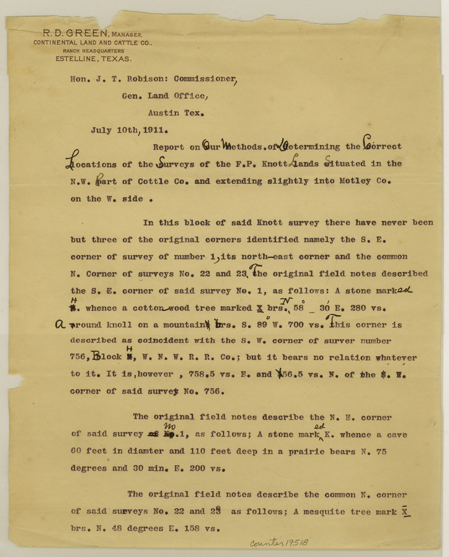
Cottle County Sketch File 16
[Report determining the correct locations of the surveys of the F. P. Knott lands situated in the northwest part of Cottle County]
-
Map/Doc
19518
-
Collection
General Map Collection
-
Object Dates
1911/7/10 (Creation Date)
1911/9/2 (File Date)
-
People and Organizations
Jno. W. Carroll (Surveyor/Engineer)
B.F. Moore (Surveyor/Engineer)
Geo. H. Chipman (Surveyor/Engineer)
-
Counties
Cottle Motley Hall
-
Subjects
Surveying Sketch File
-
Height x Width
10.7 x 8.7 inches
27.2 x 22.1 cm
-
Medium
paper, print
Part of: General Map Collection
Controlled Mosaic by Jack Amman Photogrammetric Engineers, Inc - Sheet 52

Print $20.00
- Digital $50.00
Controlled Mosaic by Jack Amman Photogrammetric Engineers, Inc - Sheet 52
1954
Size 20.0 x 24.0 inches
Map/Doc 83511
Baylor County Rolled Sketch BHK

Print $20.00
- Digital $50.00
Baylor County Rolled Sketch BHK
1892
Size 18.8 x 43.5 inches
Map/Doc 5130

Reagan County Rolled Sketch 14

Print $20.00
- Digital $50.00
Reagan County Rolled Sketch 14
1942
Size 19.8 x 21.2 inches
Map/Doc 7442
Uvalde County Sketch File 18

Print $6.00
- Digital $50.00
Uvalde County Sketch File 18
1883
Size 10.9 x 8.2 inches
Map/Doc 38997
Brazoria County NRC Article 33.136 Sketch 1

Print $20.00
- Digital $50.00
Brazoria County NRC Article 33.136 Sketch 1
2000
Size 24.7 x 35.9 inches
Map/Doc 61555
Schleicher County Working Sketch 23

Print $20.00
- Digital $50.00
Schleicher County Working Sketch 23
1953
Size 42.6 x 40.6 inches
Map/Doc 63825
Menard County Working Sketch 34

Print $20.00
- Digital $50.00
Menard County Working Sketch 34
2003
Size 27.1 x 44.4 inches
Map/Doc 82028
Crockett County Working Sketch 91

Print $20.00
- Digital $50.00
Crockett County Working Sketch 91
1978
Size 32.8 x 32.4 inches
Map/Doc 68424
Nueces County Rolled Sketch 128

Print $20.00
- Digital $50.00
Nueces County Rolled Sketch 128
1998
Size 18.3 x 24.5 inches
Map/Doc 7163
Baylor County Sketch File Z3

Print $8.00
- Digital $50.00
Baylor County Sketch File Z3
1908
Size 12.9 x 8.3 inches
Map/Doc 14110
Hardeman County

Print $20.00
- Digital $50.00
Hardeman County
1935
Size 45.1 x 42.2 inches
Map/Doc 1848
You may also like
Flight Mission No. BQR-9K, Frame 13, Brazoria County

Print $20.00
- Digital $50.00
Flight Mission No. BQR-9K, Frame 13, Brazoria County
1952
Size 19.0 x 22.6 inches
Map/Doc 84042
Right of Way and Track Map - Houston & Texas Central R.R. operated by the T. and N. O. R.R. Co. - Fort Worth Branch

Print $40.00
- Digital $50.00
Right of Way and Track Map - Houston & Texas Central R.R. operated by the T. and N. O. R.R. Co. - Fort Worth Branch
1918
Size 25.3 x 57.3 inches
Map/Doc 82860
Gaines County Rolled Sketch 29

Print $20.00
- Digital $50.00
Gaines County Rolled Sketch 29
1990
Size 14.7 x 20.5 inches
Map/Doc 5942
Flight Mission No. BRE-1P, Frame 49, Nueces County

Print $20.00
- Digital $50.00
Flight Mission No. BRE-1P, Frame 49, Nueces County
1956
Size 18.4 x 22.2 inches
Map/Doc 86638
[Map of the San Antonio del Encinal as Corrected]
![4459, [Map of the San Antonio del Encinal as Corrected], Maddox Collection](https://historictexasmaps.com/wmedia_w700/maps/4459.tif.jpg)
Print $20.00
- Digital $50.00
[Map of the San Antonio del Encinal as Corrected]
Size 28.5 x 30.7 inches
Map/Doc 4459
Texas Intracoastal Waterway - Matagorda Bay, Cedar Lakes to Oyster Lake

Digital $50.00
Texas Intracoastal Waterway - Matagorda Bay, Cedar Lakes to Oyster Lake
1956
Size 27.5 x 38.6 inches
Map/Doc 73368
[Strip between Block 8 and Block K4]
![90601, [Strip between Block 8 and Block K4], Twichell Survey Records](https://historictexasmaps.com/wmedia_w700/maps/90601-1.tif.jpg)
Print $2.00
- Digital $50.00
[Strip between Block 8 and Block K4]
Size 8.8 x 11.7 inches
Map/Doc 90601
Anderson County Working Sketch 39

Print $20.00
- Digital $50.00
Anderson County Working Sketch 39
1986
Size 21.6 x 21.8 inches
Map/Doc 67039
Flight Mission No. CRC-2R, Frame 63, Chambers County

Print $20.00
- Digital $50.00
Flight Mission No. CRC-2R, Frame 63, Chambers County
1956
Size 18.8 x 22.4 inches
Map/Doc 84734
The Great European Alliance against the Mexican Republic

Print $20.00
- Digital $50.00
The Great European Alliance against the Mexican Republic
1861
Size 22.9 x 16.2 inches
Map/Doc 96429

Flight Mission No. DCL-7C, Frame 15, Kenedy County

Print $20.00
- Digital $50.00
Flight Mission No. DCL-7C, Frame 15, Kenedy County
1943
Size 15.4 x 15.3 inches
Map/Doc 86007