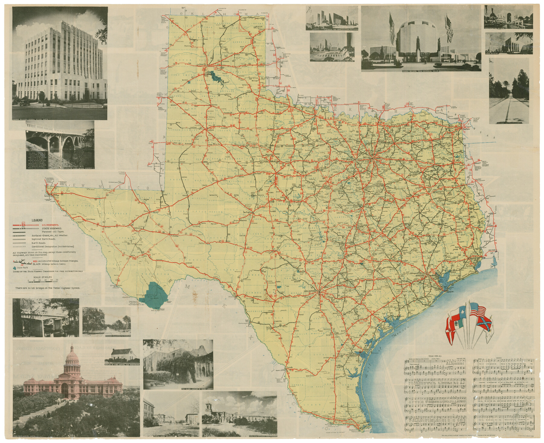
Official Map of the Highway System of Texas
-
Map/Doc
83598
-
Collection
General Map Collection
-
Object Dates
3/1/1936 (Creation Date)
4/28/2006 (File Date)
-
People and Organizations
State Highway Commission (Publisher)
State Highway Commission (Printer)
R.M. Stene (Compiler)
R.M. Stene (Draftsman)
-
Subjects
State of Texas
-
Height x Width
27.5 x 33.4 inches
69.9 x 84.8 cm
-
Comments
Features photographs from around Texas and includes music and lyrics for the song "Texas Over All". See 83599 for reverse of this map.
-
URLs
https://medium.com/save-texas-history/official-map-of-the-highway-system-of-texas-1936-46049c7a6dae#.qpxb01nv7
Part of: General Map Collection
Zavala County Working Sketch 11

Print $20.00
- Digital $50.00
Zavala County Working Sketch 11
1955
Size 13.8 x 22.4 inches
Map/Doc 62086

Runnels County Rolled Sketch 33

Print $20.00
- Digital $50.00
Runnels County Rolled Sketch 33
Size 22.5 x 43.5 inches
Map/Doc 7520
Flight Mission No. DCL-6C, Frame 123, Kenedy County

Print $20.00
- Digital $50.00
Flight Mission No. DCL-6C, Frame 123, Kenedy County
1943
Size 18.6 x 22.3 inches
Map/Doc 85953
Goliad County Sketch File 10

Print $4.00
- Digital $50.00
Goliad County Sketch File 10
1859
Size 9.3 x 8.1 inches
Map/Doc 24226
Flight Mission No. DAH-9M, Frame 198, Orange County

Print $20.00
- Digital $50.00
Flight Mission No. DAH-9M, Frame 198, Orange County
1953
Size 18.6 x 22.5 inches
Map/Doc 86866
Ochiltree County Sketch File 12

Print $24.00
- Digital $50.00
Ochiltree County Sketch File 12
1990
Size 11.2 x 8.5 inches
Map/Doc 33201
Flight Mission No. BRA-16M, Frame 57, Jefferson County

Print $20.00
- Digital $50.00
Flight Mission No. BRA-16M, Frame 57, Jefferson County
1953
Size 18.3 x 22.5 inches
Map/Doc 85674
Webb County Working Sketch 9

Print $20.00
- Digital $50.00
Webb County Working Sketch 9
1911
Size 17.2 x 30.8 inches
Map/Doc 72374
Blanco County Sketch File 16

Print $20.00
- Digital $50.00
Blanco County Sketch File 16
1861
Size 19.9 x 15.8 inches
Map/Doc 10929

Port Facilities at Texas City, Tex.

Print $20.00
- Digital $50.00
Port Facilities at Texas City, Tex.
1924
Size 13.9 x 15.9 inches
Map/Doc 97161
You may also like
Flight Mission No. DAG-24K, Frame 138, Matagorda County

Print $20.00
- Digital $50.00
Flight Mission No. DAG-24K, Frame 138, Matagorda County
1953
Size 18.4 x 15.8 inches
Map/Doc 86556
Hamilton County Sketch File 6

Print $6.00
- Digital $50.00
Hamilton County Sketch File 6
Size 15.7 x 10.6 inches
Map/Doc 24910
Partie Meridionale de la Riviere de Missisipi, et ses environs dans l'Amerique Septentrionale

Print $20.00
- Digital $50.00
Partie Meridionale de la Riviere de Missisipi, et ses environs dans l'Amerique Septentrionale
1718
Size 22.0 x 30.3 inches
Map/Doc 93926
Presidio County Sketch File 74

Print $8.00
- Digital $50.00
Presidio County Sketch File 74
1946
Size 11.4 x 8.8 inches
Map/Doc 34687
Flight Mission No. BRA-9M, Frame 70, Jefferson County

Print $20.00
- Digital $50.00
Flight Mission No. BRA-9M, Frame 70, Jefferson County
1953
Size 18.6 x 22.5 inches
Map/Doc 85653
Harris County Historic Topographic 25

Print $20.00
- Digital $50.00
Harris County Historic Topographic 25
1916
Size 29.2 x 22.7 inches
Map/Doc 65836
Sketch exhibiting the San Antonio River from the source to the fork of Goliad

Print $20.00
- Digital $50.00
Sketch exhibiting the San Antonio River from the source to the fork of Goliad
Size 27.5 x 16.6 inches
Map/Doc 73009
Floyd County Sketch File 17

Print $12.00
- Digital $50.00
Floyd County Sketch File 17
1913
Size 8.3 x 5.4 inches
Map/Doc 22747
Denton County Working Sketch 13

Print $20.00
- Digital $50.00
Denton County Working Sketch 13
1962
Size 25.7 x 36.2 inches
Map/Doc 68618
Pecos County Rolled Sketch 150

Print $20.00
- Digital $50.00
Pecos County Rolled Sketch 150
1958
Size 27.6 x 24.7 inches
Map/Doc 7280
[Sketch Showing Railroad land surveys in Dallam & Sherman Counties, Texas]
![75786, [Sketch Showing Railroad land surveys in Dallam & Sherman Counties, Texas], Maddox Collection](https://historictexasmaps.com/wmedia_w700/maps/75786.tif.jpg)
Print $20.00
- Digital $50.00
[Sketch Showing Railroad land surveys in Dallam & Sherman Counties, Texas]
Size 19.4 x 13.4 inches
Map/Doc 75786
Hudspeth County Rolled Sketch 41

Print $40.00
- Digital $50.00
Hudspeth County Rolled Sketch 41
1947
Size 12.6 x 83.1 inches
Map/Doc 76043