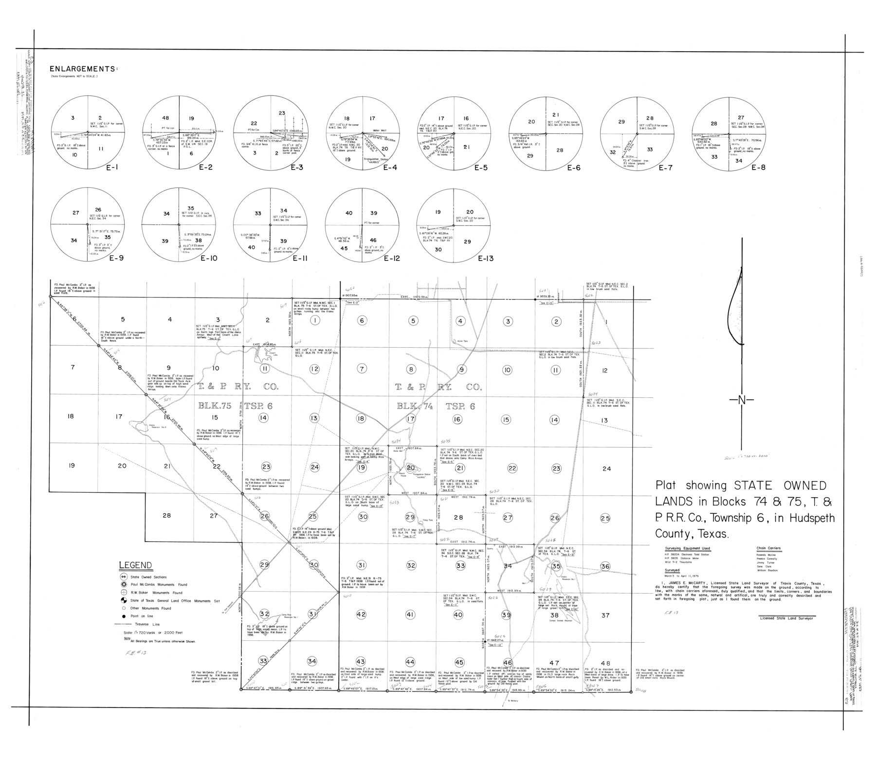
Hudspeth County Rolled Sketch 63
Plat showing state owned lands in Blocks 74 & 75, T. & P. R.R. Co., Township 6, in Hudspeth County, Texas
-
Map/Doc
9227
-
Collection
General Map Collection
-
Object Dates
4/11/1979 (Survey Date)
12/20/1979 (File Date)
-
People and Organizations
James E. McCarty (Surveyor/Engineer)
Jimmy Turner (Chainman/Field Personnel)
Gene Clark (Chainman/Field Personnel)
William Bourbon (Chainman/Field Personnel)
Preston R. Connally (Chainman/Field Personnel)
Rosendo V. Molina (Chainman/Field Personnel)
-
Counties
Hudspeth
-
Subjects
Surveying Rolled Sketch
-
Height x Width
41.8 x 47.9 inches
106.2 x 121.7 cm
-
Medium
mylar, print
-
Scale
1" = 720 varas
Part of: General Map Collection
Flight Mission No. BQR-5K, Frame 65, Brazoria County

Print $20.00
- Digital $50.00
Flight Mission No. BQR-5K, Frame 65, Brazoria County
1952
Size 18.8 x 22.5 inches
Map/Doc 84010
King County Sketch File 3

Print $20.00
- Digital $50.00
King County Sketch File 3
Size 22.2 x 27.1 inches
Map/Doc 11934
Webb County Sketch File 65

Print $10.00
- Digital $50.00
Webb County Sketch File 65
1949
Size 14.5 x 8.9 inches
Map/Doc 39865
Dickens County Rolled Sketch 5

Print $40.00
- Digital $50.00
Dickens County Rolled Sketch 5
1947
Size 60.2 x 40.3 inches
Map/Doc 8787
Coast Chart No. 210 - Aransas Pass and Corpus Christi Bay with the coast to latitude 27° 12', Texas

Print $20.00
- Digital $50.00
Coast Chart No. 210 - Aransas Pass and Corpus Christi Bay with the coast to latitude 27° 12', Texas
1907
Size 18.4 x 24.2 inches
Map/Doc 73450
Flight Mission No. DAG-22K, Frame 84, Matagorda County

Print $20.00
- Digital $50.00
Flight Mission No. DAG-22K, Frame 84, Matagorda County
1953
Size 15.7 x 15.6 inches
Map/Doc 86468
Kent County Working Sketch 8

Print $20.00
- Digital $50.00
Kent County Working Sketch 8
1952
Size 27.2 x 37.1 inches
Map/Doc 70015
Coryell County Sketch File 2

Print $4.00
- Digital $50.00
Coryell County Sketch File 2
Size 13.0 x 8.0 inches
Map/Doc 19338
Nueces County Rolled Sketch 113A

Print $20.00
- Digital $50.00
Nueces County Rolled Sketch 113A
1972
Size 19.1 x 24.4 inches
Map/Doc 7121
Reeves County Working Sketch 22

Print $20.00
- Digital $50.00
Reeves County Working Sketch 22
1966
Size 31.2 x 46.8 inches
Map/Doc 63465
Hardin County Sketch File 10

Print $4.00
- Digital $50.00
Hardin County Sketch File 10
1862
Size 12.5 x 8.0 inches
Map/Doc 25110
Flight Mission No. DIX-7P, Frame 23, Aransas County

Print $20.00
- Digital $50.00
Flight Mission No. DIX-7P, Frame 23, Aransas County
1956
Size 18.7 x 22.4 inches
Map/Doc 83875
You may also like
Map of Milam County

Print $40.00
- Digital $50.00
Map of Milam County
1839
Size 54.5 x 45.9 inches
Map/Doc 3881
Gaines County Sketch File 12

Print $4.00
- Digital $50.00
Gaines County Sketch File 12
1950
Size 14.3 x 8.8 inches
Map/Doc 23198
Hutchinson County Working Sketch 29

Print $20.00
- Digital $50.00
Hutchinson County Working Sketch 29
1978
Size 26.5 x 22.1 inches
Map/Doc 66389
Coleman County Sketch File 44

Print $17.00
- Digital $50.00
Coleman County Sketch File 44
Size 14.1 x 8.6 inches
Map/Doc 18783
Presidio County Working Sketch 95

Print $40.00
- Digital $50.00
Presidio County Working Sketch 95
1976
Size 62.8 x 32.0 inches
Map/Doc 71772
Galveston County Sketch File 66

Print $116.00
- Digital $50.00
Galveston County Sketch File 66
Size 5.0 x 10.0 inches
Map/Doc 23751
Kendall County Working Sketch 24

Print $20.00
- Digital $50.00
Kendall County Working Sketch 24
1977
Size 27.6 x 26.1 inches
Map/Doc 66696
[Surveys in McMullen and McGloin's Colony along the San Antonio River]
![30, [Surveys in McMullen and McGloin's Colony along the San Antonio River], General Map Collection](https://historictexasmaps.com/wmedia_w700/maps/30-1.tif.jpg)
Print $20.00
- Digital $50.00
[Surveys in McMullen and McGloin's Colony along the San Antonio River]
1828
Size 19.3 x 24.5 inches
Map/Doc 30
Flight Mission No. BRA-9M, Frame 70, Jefferson County

Print $20.00
- Digital $50.00
Flight Mission No. BRA-9M, Frame 70, Jefferson County
1953
Size 18.6 x 22.5 inches
Map/Doc 85653
Hardin County Sketch File 5a

Print $6.00
- Digital $50.00
Hardin County Sketch File 5a
Size 8.1 x 3.5 inches
Map/Doc 25094
Montague County Rolled Sketch 1

Print $20.00
- Digital $50.00
Montague County Rolled Sketch 1
Size 31.7 x 26.9 inches
Map/Doc 6786
