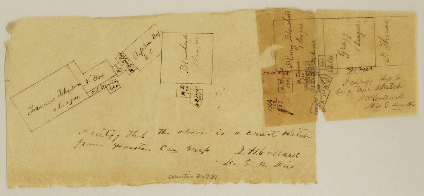
Houston County Sketch File 18
[Sketch on headwaters of White Rock Creek]
-
Map/Doc
26781
-
Collection
General Map Collection
-
Object Dates
8/18/1859 (File Date)
-
People and Organizations
J.H. Collard (Surveyor/Engineer)
-
Counties
Houston
-
Subjects
Surveying Sketch File
-
Height x Width
4.8 x 10.3 inches
12.2 x 26.2 cm
-
Medium
paper, manuscript
-
Features
White Rock Creek
Part of: General Map Collection
Crosby County
![95472, Crosby County, General Map Collection](https://historictexasmaps.com/wmedia_w700/maps/95472.tif.jpg)
Print $20.00
- Digital $50.00
Crosby County
1927
Size 41.2 x 36.4 inches
Map/Doc 95472
El Paso County Sketch File 35 (6)
![11460, El Paso County Sketch File 35 (6), General Map Collection](https://historictexasmaps.com/wmedia_w700/pdf_converted_jpg/qi_pdf_thumbnail_7915.jpg)
Print $20.00
- Digital $50.00
El Paso County Sketch File 35 (6)
1886
Size 20.3 x 36.9 inches
Map/Doc 11460
Texas Intracoastal Waterway - Stover Point to Port Brownsville including Brazos Santiago
![73519, Texas Intracoastal Waterway - Stover Point to Port Brownsville including Brazos Santiago, General Map Collection](https://historictexasmaps.com/wmedia_w700/maps/73519.tif.jpg)
Print $20.00
- Digital $50.00
Texas Intracoastal Waterway - Stover Point to Port Brownsville including Brazos Santiago
1961
Size 27.2 x 38.9 inches
Map/Doc 73519
Liberty County Rolled Sketch 14
![6620, Liberty County Rolled Sketch 14, General Map Collection](https://historictexasmaps.com/wmedia_w700/maps/6620.tif.jpg)
Print $20.00
- Digital $50.00
Liberty County Rolled Sketch 14
Size 33.2 x 43.9 inches
Map/Doc 6620
Bastrop County Sketch File 5
![14048, Bastrop County Sketch File 5, General Map Collection](https://historictexasmaps.com/wmedia_w700/pdf_converted_jpg/qi_pdf_thumbnail_9254.jpg)
Print $4.00
- Digital $50.00
Bastrop County Sketch File 5
Size 8.1 x 10.2 inches
Map/Doc 14048
Reconnaissance of Aransas Pass, Texas
![76171, Reconnaissance of Aransas Pass, Texas, General Map Collection](https://historictexasmaps.com/wmedia_w700/maps/76171.tif.jpg)
Print $20.00
- Digital $50.00
Reconnaissance of Aransas Pass, Texas
1852
Size 14.4 x 13.6 inches
Map/Doc 76171
Sutton County Rolled Sketch 58
![7896, Sutton County Rolled Sketch 58, General Map Collection](https://historictexasmaps.com/wmedia_w700/maps/7896.tif.jpg)
Print $20.00
- Digital $50.00
Sutton County Rolled Sketch 58
Size 31.2 x 15.9 inches
Map/Doc 7896
Concho County Sketch File 28
![19166, Concho County Sketch File 28, General Map Collection](https://historictexasmaps.com/wmedia_w700/pdf_converted_jpg/qi_pdf_thumbnail_10343.jpg)
Print $6.00
- Digital $50.00
Concho County Sketch File 28
1887
Size 16.2 x 8.3 inches
Map/Doc 19166
Dawson County Boundary File 3 (1)
![52365, Dawson County Boundary File 3 (1), General Map Collection](https://historictexasmaps.com/wmedia_w700/pdf_converted_jpg/qi_pdf_thumbnail_15872.jpg)
Print $40.00
- Digital $50.00
Dawson County Boundary File 3 (1)
Size 11.1 x 35.8 inches
Map/Doc 52365
PSL Field Notes for Blocks 60, 61, 62, 83, 84, 85, 88, 89, 90, 91, 92, and 93 in Culberson County
![81667, PSL Field Notes for Blocks 60, 61, 62, 83, 84, 85, 88, 89, 90, 91, 92, and 93 in Culberson County, General Map Collection](https://historictexasmaps.com/wmedia_w700/pdf_converted_jpg/qi_pdf_thumbnail_30430.jpg)
PSL Field Notes for Blocks 60, 61, 62, 83, 84, 85, 88, 89, 90, 91, 92, and 93 in Culberson County
Map/Doc 81667
[Copy of a portion of] The Coast & Bays of Western Texas, St. Joseph's and Mustang Islands from Actual Survey, the Remainder from County Maps, Etc.
![72769, [Copy of a portion of] The Coast & Bays of Western Texas, St. Joseph's and Mustang Islands from Actual Survey, the Remainder from County Maps, Etc., General Map Collection](https://historictexasmaps.com/wmedia_w700/maps/72769.tif.jpg)
Print $20.00
- Digital $50.00
[Copy of a portion of] The Coast & Bays of Western Texas, St. Joseph's and Mustang Islands from Actual Survey, the Remainder from County Maps, Etc.
1857
Size 25.9 x 18.3 inches
Map/Doc 72769
Travis County Boundary File 31
![59471, Travis County Boundary File 31, General Map Collection](https://historictexasmaps.com/wmedia_w700/pdf_converted_jpg/qi_pdf_thumbnail_16884.jpg)
Print $4.00
- Digital $50.00
Travis County Boundary File 31
Size 10.0 x 8.2 inches
Map/Doc 59471
You may also like
Travis County Appraisal District Plat Map 2_3216
![94223, Travis County Appraisal District Plat Map 2_3216, General Map Collection](https://historictexasmaps.com/wmedia_w700/maps/94223.tif.jpg)
Print $20.00
- Digital $50.00
Travis County Appraisal District Plat Map 2_3216
Size 21.5 x 26.4 inches
Map/Doc 94223
Montgomery County Sketch File 9
![31795, Montgomery County Sketch File 9, General Map Collection](https://historictexasmaps.com/wmedia_w700/pdf_converted_jpg/qi_pdf_thumbnail_13151.jpg)
Print $6.00
- Digital $50.00
Montgomery County Sketch File 9
Size 9.0 x 7.6 inches
Map/Doc 31795
Flight Mission No. CRC-5R, Frame 43, Chambers County
![84962, Flight Mission No. CRC-5R, Frame 43, Chambers County, General Map Collection](https://historictexasmaps.com/wmedia_w700/pdf_converted_jpg/qi_pdf_thumbnail_32174.jpg)
Print $20.00
- Digital $50.00
Flight Mission No. CRC-5R, Frame 43, Chambers County
1956
Size 18.6 x 22.3 inches
Map/Doc 84962
Stonewall County
![95646, Stonewall County, General Map Collection](https://historictexasmaps.com/wmedia_w700/maps/95646.tif.jpg)
Print $40.00
- Digital $50.00
Stonewall County
1933
Size 48.0 x 39.4 inches
Map/Doc 95646
General Highway Map, Waller County, Texas
![79270, General Highway Map, Waller County, Texas, Texas State Library and Archives](https://historictexasmaps.com/wmedia_w700/maps/79270.tif.jpg)
Print $20.00
General Highway Map, Waller County, Texas
1939
Size 25.1 x 18.5 inches
Map/Doc 79270
Republic Counties. January 1, 1843
![96316, Republic Counties. January 1, 1843, Nancy and Jim Tiller Digital Collection](https://historictexasmaps.com/wmedia_w700/maps/96316.tif.jpg)
Print $20.00
- Digital $50.00
Republic Counties. January 1, 1843
2020
Size 12.3 x 10.8 inches
Map/Doc 96316
Old Miscellaneous File 5
![75418, Old Miscellaneous File 5, General Map Collection](https://historictexasmaps.com/wmedia_w700/pdf_converted_jpg/qi_pdf_thumbnail_28014.jpg)
Print $4.00
- Digital $50.00
Old Miscellaneous File 5
1846
Size 4.8 x 7.6 inches
Map/Doc 75418
[Section 34 1/2 and Blk.194, Jno. H. Tyler and Bob Reid Surveys, Yates Field]
![91622, [Section 34 1/2 and Blk.194, Jno. H. Tyler and Bob Reid Surveys, Yates Field], Twichell Survey Records](https://historictexasmaps.com/wmedia_w700/maps/91622-1.tif.jpg)
Print $20.00
- Digital $50.00
[Section 34 1/2 and Blk.194, Jno. H. Tyler and Bob Reid Surveys, Yates Field]
Size 22.7 x 20.6 inches
Map/Doc 91622
Matagorda County Rolled Sketch 29
![6691, Matagorda County Rolled Sketch 29, General Map Collection](https://historictexasmaps.com/wmedia_w700/maps/6691.tif.jpg)
Print $20.00
- Digital $50.00
Matagorda County Rolled Sketch 29
1936
Size 36.6 x 27.2 inches
Map/Doc 6691
The Judicial District/County of Guadalupe. Created, January 29, 1842
![96327, The Judicial District/County of Guadalupe. Created, January 29, 1842, Nancy and Jim Tiller Digital Collection](https://historictexasmaps.com/wmedia_w700/maps/96327.tif.jpg)
Print $20.00
- Digital $50.00
The Judicial District/County of Guadalupe. Created, January 29, 1842
2020
Size 8.3 x 10.8 inches
Map/Doc 96327
Sur. Sketch S. F. 6855
![90788, Sur. Sketch S. F. 6855, Twichell Survey Records](https://historictexasmaps.com/wmedia_w700/maps/90788-1.tif.jpg)
Print $20.00
- Digital $50.00
Sur. Sketch S. F. 6855
Size 20.2 x 10.2 inches
Map/Doc 90788
Kerr County Working Sketch 23
![70054, Kerr County Working Sketch 23, General Map Collection](https://historictexasmaps.com/wmedia_w700/maps/70054-1.tif.jpg)
Print $20.00
- Digital $50.00
Kerr County Working Sketch 23
Size 33.4 x 41.0 inches
Map/Doc 70054