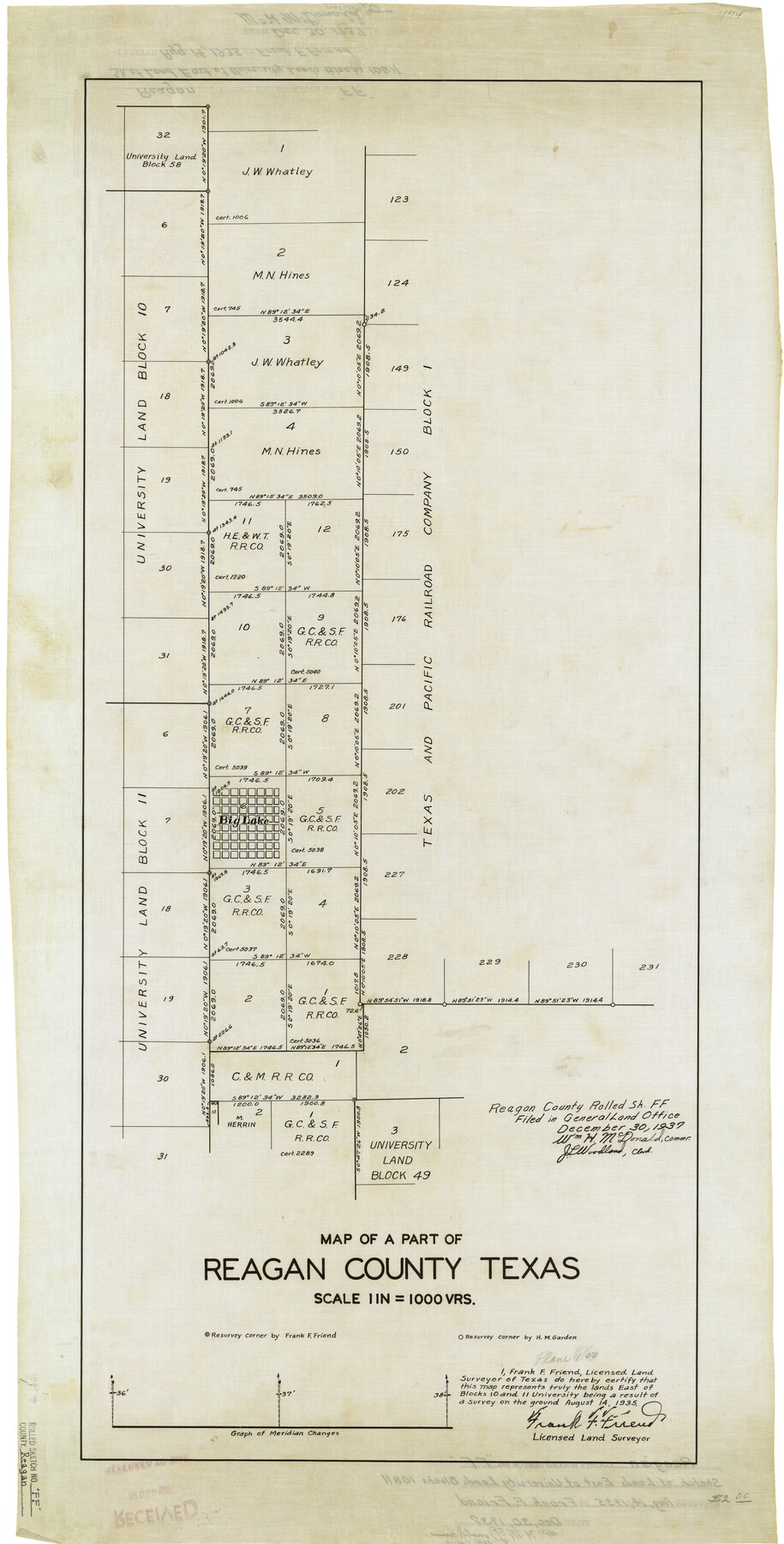
Reagan County Rolled Sketch FF
Map of a part of Reagan County, Texas
-
Map/Doc
7451
-
Collection
General Map Collection
-
Object Dates
1935/8/14 (Survey Date)
1937/12/30 (File Date)
-
People and Organizations
Frank F. Friend (Surveyor/Engineer)
-
Counties
Reagan
-
Subjects
Surveying Rolled Sketch
-
Height x Width
35.0 x 17.8 inches
88.9 x 45.2 cm
-
Medium
linen, manuscript
-
Scale
1" = 1000 varas
Part of: General Map Collection
Montgomery County Working Sketch 70

Print $20.00
- Digital $50.00
Montgomery County Working Sketch 70
1973
Size 41.3 x 31.7 inches
Map/Doc 71177
Jeff Davis County Rolled Sketch 32

Print $20.00
- Digital $50.00
Jeff Davis County Rolled Sketch 32
1984
Size 16.3 x 24.5 inches
Map/Doc 7721
Parker County Working Sketch 15

Print $20.00
- Digital $50.00
Parker County Working Sketch 15
1982
Map/Doc 71465
Young County Sketch File 12

Print $4.00
- Digital $50.00
Young County Sketch File 12
1889
Size 8.5 x 13.6 inches
Map/Doc 40876
Brazoria County Sketch File 33

Print $40.00
- Digital $50.00
Brazoria County Sketch File 33
Size 21.9 x 24.1 inches
Map/Doc 10957
Live Oak County Working Sketch 15

Print $20.00
- Digital $50.00
Live Oak County Working Sketch 15
1952
Size 23.8 x 22.6 inches
Map/Doc 70600
Stephens County Sketch File 27

Print $6.00
- Digital $50.00
Stephens County Sketch File 27
Size 9.7 x 8.5 inches
Map/Doc 37101
Northeast Part Presidio County

Print $20.00
- Digital $50.00
Northeast Part Presidio County
1973
Size 39.6 x 31.3 inches
Map/Doc 77398
Jeff Davis County Rolled Sketch 19A

Print $20.00
- Digital $50.00
Jeff Davis County Rolled Sketch 19A
Size 33.3 x 39.0 inches
Map/Doc 9266
Flight Mission No. BRE-2P, Frame 138, Nueces County

Print $20.00
- Digital $50.00
Flight Mission No. BRE-2P, Frame 138, Nueces County
1956
Size 18.5 x 22.2 inches
Map/Doc 86811
Map of Nolan County

Print $20.00
- Digital $50.00
Map of Nolan County
1902
Size 45.9 x 38.4 inches
Map/Doc 16780
Flight Mission No. CRC-2R, Frame 2, Chambers County

Print $20.00
- Digital $50.00
Flight Mission No. CRC-2R, Frame 2, Chambers County
1956
Size 18.6 x 22.4 inches
Map/Doc 84721
You may also like
Dallas County Sketch File 20

Print $4.00
- Digital $50.00
Dallas County Sketch File 20
Size 12.2 x 7.8 inches
Map/Doc 20441
Brewster County Working Sketch 27

Print $20.00
- Digital $50.00
Brewster County Working Sketch 27
1940
Size 31.2 x 33.1 inches
Map/Doc 67561
Van Zandt County Sketch File 14

Print $4.00
- Digital $50.00
Van Zandt County Sketch File 14
1858
Size 7.9 x 8.1 inches
Map/Doc 39404
Culberson County Sketch File 42

Print $14.00
- Digital $50.00
Culberson County Sketch File 42
1966
Size 14.2 x 8.7 inches
Map/Doc 20322
Milam District

Print $20.00
- Digital $50.00
Milam District
1854
Size 30.2 x 18.9 inches
Map/Doc 3859
Limestone County Sketch File 25

Print $20.00
- Digital $50.00
Limestone County Sketch File 25
Size 25.1 x 32.8 inches
Map/Doc 12003
PSL Field Notes for Block C41 in Dawson, Lynn, and Terry Counties, Block C42 in Lynn and Terry Counties, and Blocks C40 and D23 in Lynn County

PSL Field Notes for Block C41 in Dawson, Lynn, and Terry Counties, Block C42 in Lynn and Terry Counties, and Blocks C40 and D23 in Lynn County
Map/Doc 81668
Bell County Sketch File 12a

Print $6.00
- Digital $50.00
Bell County Sketch File 12a
1853
Size 12.8 x 8.0 inches
Map/Doc 14387
Leon County Rolled Sketch 34

Print $20.00
- Digital $50.00
Leon County Rolled Sketch 34
1999
Size 31.8 x 37.1 inches
Map/Doc 87502
Castro County Rolled Sketch 13A

Print $20.00
- Digital $50.00
Castro County Rolled Sketch 13A
1967
Size 20.0 x 18.9 inches
Map/Doc 5423
Jasper County Sketch File 5

Print $4.00
- Digital $50.00
Jasper County Sketch File 5
Size 8.4 x 12.1 inches
Map/Doc 27770
Collin County

Print $20.00
- Digital $50.00
Collin County
1975
Size 43.2 x 40.1 inches
Map/Doc 73110