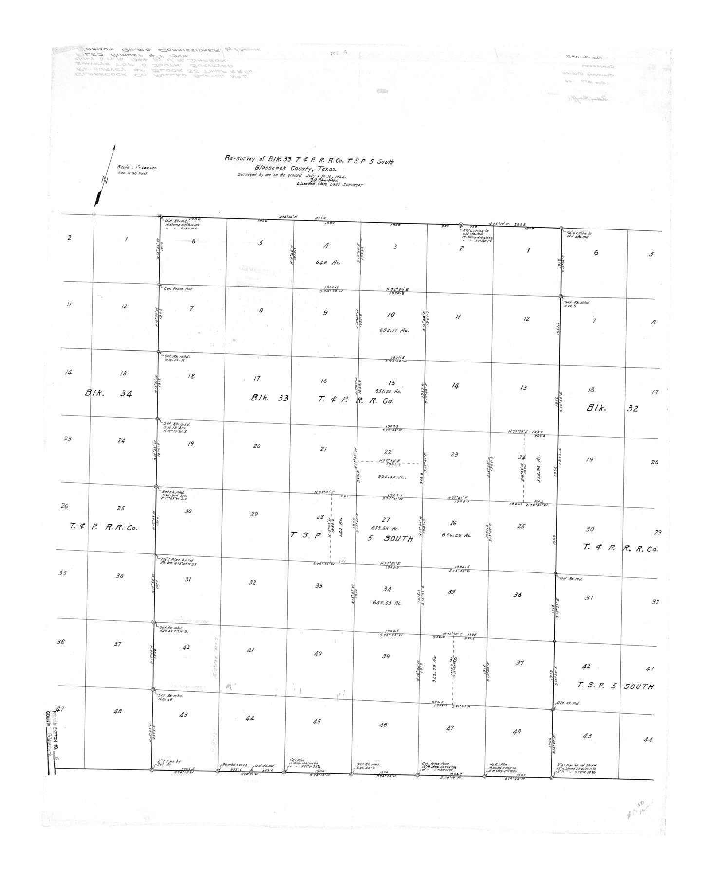
Glasscock County Rolled Sketch 5
Re-survey of Blk. 33, T. & P. R.R. Co., Tsp 5 South
-
Map/Doc
6016
-
Collection
General Map Collection
-
Object Dates
1944/7/16 (Creation Date)
1944/8/4 (File Date)
-
People and Organizations
J.A. Simpson (Surveyor/Engineer)
-
Counties
Glasscock
-
Subjects
Surveying Rolled Sketch
-
Height x Width
41.4 x 33.7 inches
105.2 x 85.6 cm
-
Scale
1" = 600 varas
Part of: General Map Collection
Bexar County Working Sketch 7

Print $20.00
- Digital $50.00
Bexar County Working Sketch 7
1947
Size 21.8 x 37.6 inches
Map/Doc 67323
Terrell County Rolled Sketch 21

Print $20.00
- Digital $50.00
Terrell County Rolled Sketch 21
Size 19.1 x 27.7 inches
Map/Doc 7929
Flight Mission No. DAG-24K, Frame 51, Matagorda County

Print $20.00
- Digital $50.00
Flight Mission No. DAG-24K, Frame 51, Matagorda County
1953
Size 16.0 x 15.9 inches
Map/Doc 86538
Travis County Working Sketch 32

Print $20.00
- Digital $50.00
Travis County Working Sketch 32
1965
Size 28.0 x 40.0 inches
Map/Doc 69416
Brazoria County Rolled Sketch 40

Print $20.00
- Digital $50.00
Brazoria County Rolled Sketch 40
1954
Size 32.1 x 21.5 inches
Map/Doc 5175
Capitol Complex, Austin, Texas

Print $20.00
- Digital $50.00
Capitol Complex, Austin, Texas
1974
Size 42.7 x 30.6 inches
Map/Doc 94241
Map of Erath County

Print $40.00
- Digital $50.00
Map of Erath County
1896
Size 50.4 x 45.1 inches
Map/Doc 7820
Cottle County Working Sketch 19

Print $20.00
- Digital $50.00
Cottle County Working Sketch 19
1978
Size 33.2 x 29.3 inches
Map/Doc 68329

Kerr County Working Sketch 32

Print $20.00
- Digital $50.00
Kerr County Working Sketch 32
1975
Size 33.8 x 25.3 inches
Map/Doc 70063
Flight Mission No. CZW-2R, Frame 66, Hardeman County

Print $20.00
- Digital $50.00
Flight Mission No. CZW-2R, Frame 66, Hardeman County
1956
Size 18.6 x 22.4 inches
Map/Doc 85239
Texas, Corpus Christi Bay, Mustang Island

Print $40.00
- Digital $50.00
Texas, Corpus Christi Bay, Mustang Island
1934
Size 48.6 x 31.4 inches
Map/Doc 73460
You may also like
Rains County Sketch File 4

Print $4.00
- Digital $50.00
Rains County Sketch File 4
1853
Size 11.2 x 8.7 inches
Map/Doc 34951
Bandera County Working Sketch 15

Print $20.00
- Digital $50.00
Bandera County Working Sketch 15
1938
Size 18.1 x 17.4 inches
Map/Doc 67608
Chambers County Working Sketch 29

Print $20.00
- Digital $50.00
Chambers County Working Sketch 29
2009
Size 25.2 x 18.6 inches
Map/Doc 89232
Atascosa County Working Sketch 15

Print $40.00
- Digital $50.00
Atascosa County Working Sketch 15
1935
Size 43.8 x 53.6 inches
Map/Doc 67211
Culberson County Sketch File D

Print $32.00
- Digital $50.00
Culberson County Sketch File D
1915
Size 7.4 x 8.8 inches
Map/Doc 20189
Close-up: USA - The South Central States

Close-up: USA - The South Central States
1974
Size 23.2 x 35.2 inches
Map/Doc 96846
Matagorda County Sketch File 44

Print $37.00
- Digital $50.00
Matagorda County Sketch File 44
Size 11.2 x 8.8 inches
Map/Doc 77096
Crane County Working Sketch 15

Print $20.00
- Digital $50.00
Crane County Working Sketch 15
1946
Size 33.6 x 38.0 inches
Map/Doc 68292
Kimble County Working Sketch 29

Print $20.00
- Digital $50.00
Kimble County Working Sketch 29
1941
Size 24.7 x 15.3 inches
Map/Doc 70097

Hopkins County Sketch File 23

Print $4.00
- Digital $50.00
Hopkins County Sketch File 23
1871
Size 12.6 x 8.4 inches
Map/Doc 26732
Calcasieu Pass to Sabine Pass

Print $20.00
- Digital $50.00
Calcasieu Pass to Sabine Pass
1950
Size 44.8 x 35.4 inches
Map/Doc 69808