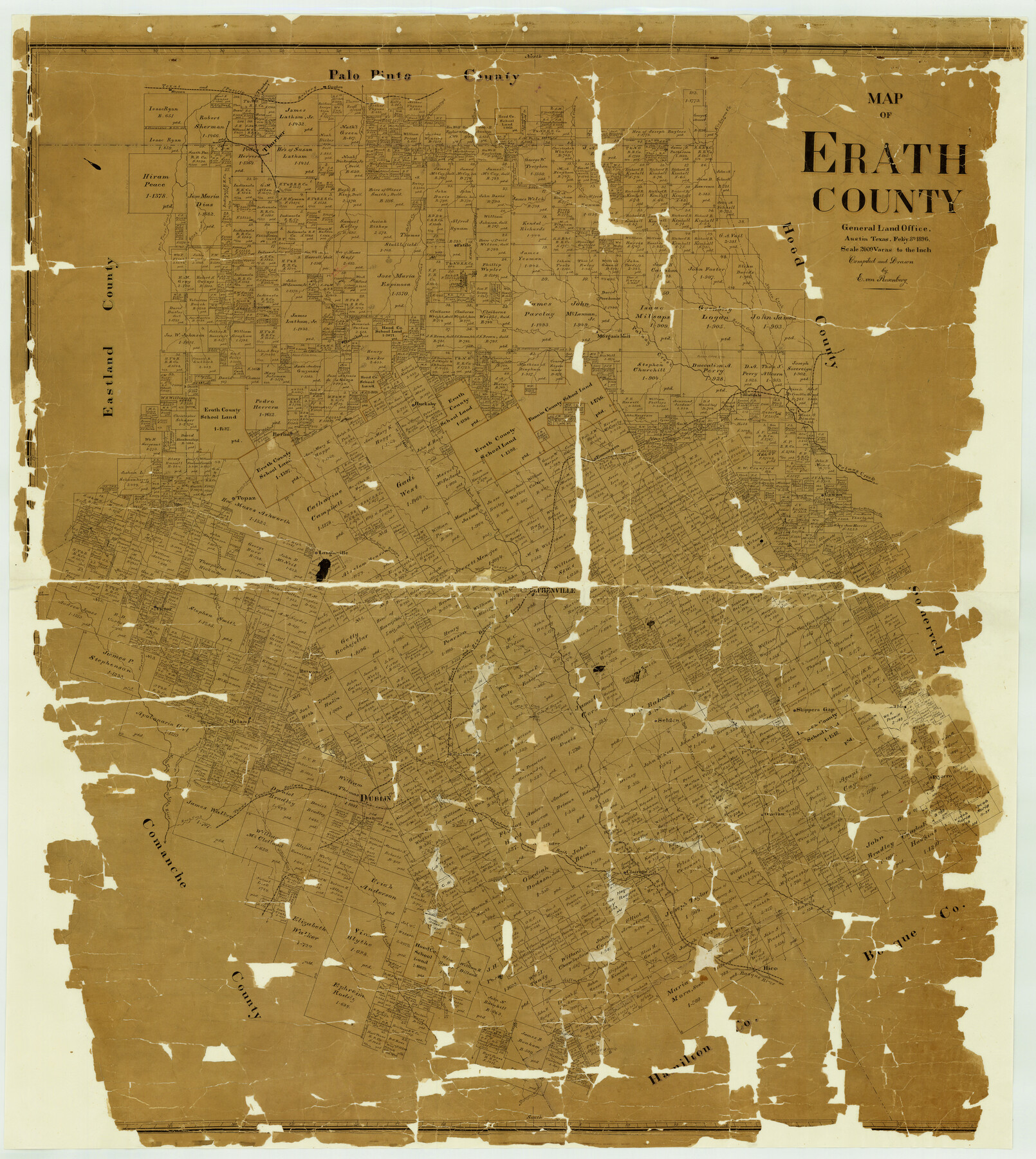
Map of Erath County
-
Map/Doc
7820
-
Collection
General Map Collection
-
Object Dates
1896/2/8 (Creation Date)
-
People and Organizations
Texas General Land Office (Publisher)
E. von Rosenberg (Draftsman)
E. von Rosenberg (Compiler)
-
Counties
Erath
-
Subjects
County
-
Height x Width
50.4 x 45.1 inches
128.0 x 114.6 cm
-
Comments
Conservation funded in 2001 with donation from Heart of Texas Chapter 21, Texas Society of Professional Surveyors (TSPS).
-
Features
Village Creek
Cottonwood Creek
Dublin
TCRR
Walker Creek
North Fork of Leon River
Scott's Creek
Hyland Creek
Green's Creek
Armstrong's Creek
Duffau
West Fork of Green's Creek
Harbin
West Fork of Duffau Creek
East Fork of Duffau Creek
Selden
Duffau Creek
Skippers Gap
FW&RG
Flat Creek
Four Mile Creek
Twin Mountains
Thompson's Creek
Spring Branch
Heavenly Branch of Green's Creek
Old Indian Village
Alarm Creek
Hyland
North Fork of Bosque River
Honey Creek
Victor
Gillmour's [sic] Creek
Bosque River
Hico
Clairette
Little Green Creek
Little Walnut Creek
Rush Creek
Old Dublin
Pizarro
Palo Pinto Creek
South Paluxy Creek
Bluffdale
Morgan's Mill
Hannibal
Paluxy Creek
Berrys Creek
Allcorn Creek
Patilo
Resley's Creek
Huckaby
Thurber
Kickapoo Creek
Sunday's Creek
Saline Creek
Buck Creek
Bartons Creek
Gordon
T&P
Ice Creek
Strawn
Stephenville
Sycamore Creek
Big Kid Branch Creek
West Fork of Bosque River
Linghville
Hog Creek
Pony Creek
Black Creek
Richardson's Creek
Thurber Junction
Cowan
Head's Creek
Bunyan
Emmurmen
East Fork of Bosque River
Topaz
Leon River
Prong of Leon River
Berlin
Part of: General Map Collection
Johnson County Working Sketch 22

Print $20.00
- Digital $50.00
Johnson County Working Sketch 22
1992
Size 14.6 x 18.1 inches
Map/Doc 66635
Hood County Sketch File 16

Print $4.00
- Digital $50.00
Hood County Sketch File 16
1860
Size 10.2 x 8.2 inches
Map/Doc 26597
[Location, Fort Worth & Denver Railroad, through Wilbarger County]
![64344, [Location, Fort Worth & Denver Railroad, through Wilbarger County], General Map Collection](https://historictexasmaps.com/wmedia_w700/maps/64344.tif.jpg)
Print $40.00
- Digital $50.00
[Location, Fort Worth & Denver Railroad, through Wilbarger County]
Size 20.8 x 123.5 inches
Map/Doc 64344
Oldham County Sketch File 8

Print $4.00
- Digital $50.00
Oldham County Sketch File 8
Size 7.9 x 11.9 inches
Map/Doc 33239
Red River County Sketch File 17b

Print $4.00
- Digital $50.00
Red River County Sketch File 17b
1875
Size 12.9 x 8.1 inches
Map/Doc 35147
Texas City Channel, Texas, Channel and Turning Basin Dredging - Sheet 6

Print $20.00
- Digital $50.00
Texas City Channel, Texas, Channel and Turning Basin Dredging - Sheet 6
1958
Size 28.6 x 40.6 inches
Map/Doc 61836
Taylor County Rolled Sketch 27A

Print $20.00
- Digital $50.00
Taylor County Rolled Sketch 27A
Size 30.5 x 21.4 inches
Map/Doc 7919
Zavala County Working Sketch 1

Print $20.00
- Digital $50.00
Zavala County Working Sketch 1
Size 21.2 x 16.3 inches
Map/Doc 62076
Angelina County Sketch File 21b

Print $6.00
- Digital $50.00
Angelina County Sketch File 21b
1889
Size 13.9 x 8.5 inches
Map/Doc 13044
Brooks County Boundary File 1b

Print $20.00
- Digital $50.00
Brooks County Boundary File 1b
Size 42.2 x 6.6 inches
Map/Doc 50837
Harris County Sketch File 91

Print $141.00
- Digital $50.00
Harris County Sketch File 91
1980
Size 11.3 x 8.9 inches
Map/Doc 25600
Nueces County NRC Article 33.136 Location Key Sheet

Print $20.00
- Digital $50.00
Nueces County NRC Article 33.136 Location Key Sheet
1975
Size 27.0 x 23.0 inches
Map/Doc 88586
You may also like
Kimble County Working Sketch 61

Print $20.00
- Digital $50.00
Kimble County Working Sketch 61
1964
Size 23.4 x 21.5 inches
Map/Doc 70129
Starr County Working Sketch 3

Print $20.00
- Digital $50.00
Starr County Working Sketch 3
1920
Size 35.6 x 23.0 inches
Map/Doc 63919
[Travis District]
![88739, [Travis District], General Map Collection](https://historictexasmaps.com/wmedia_w700/maps/88739.tif.jpg)
Print $40.00
- Digital $50.00
[Travis District]
1840
Size 54.7 x 42.0 inches
Map/Doc 88739
Comal County Working Sketch 15

Print $20.00
- Digital $50.00
Comal County Working Sketch 15
1994
Size 44.6 x 31.0 inches
Map/Doc 68181
Old Miscellaneous File 13

Print $6.00
- Digital $50.00
Old Miscellaneous File 13
1899
Size 9.7 x 6.5 inches
Map/Doc 75446
Rusk County Sketch File 38

Print $6.00
Rusk County Sketch File 38
1951
Size 11.3 x 8.8 inches
Map/Doc 35576
Burnet County Boundary File 4

Print $30.00
- Digital $50.00
Burnet County Boundary File 4
Size 8.8 x 8.1 inches
Map/Doc 50872
Brown County Rolled Sketch 2B

Print $20.00
- Digital $50.00
Brown County Rolled Sketch 2B
1984
Size 24.3 x 18.6 inches
Map/Doc 5351
San Patricio County Sketch File 28

Print $53.00
San Patricio County Sketch File 28
1935
Size 9.4 x 7.0 inches
Map/Doc 36087
Ellis County Boundary File 3

Print $58.00
- Digital $50.00
Ellis County Boundary File 3
Size 14.1 x 122.4 inches
Map/Doc 52950
Flight Mission No. BQR-13K, Frame 122, Brazoria County

Print $20.00
- Digital $50.00
Flight Mission No. BQR-13K, Frame 122, Brazoria County
1952
Size 18.6 x 22.3 inches
Map/Doc 84083
