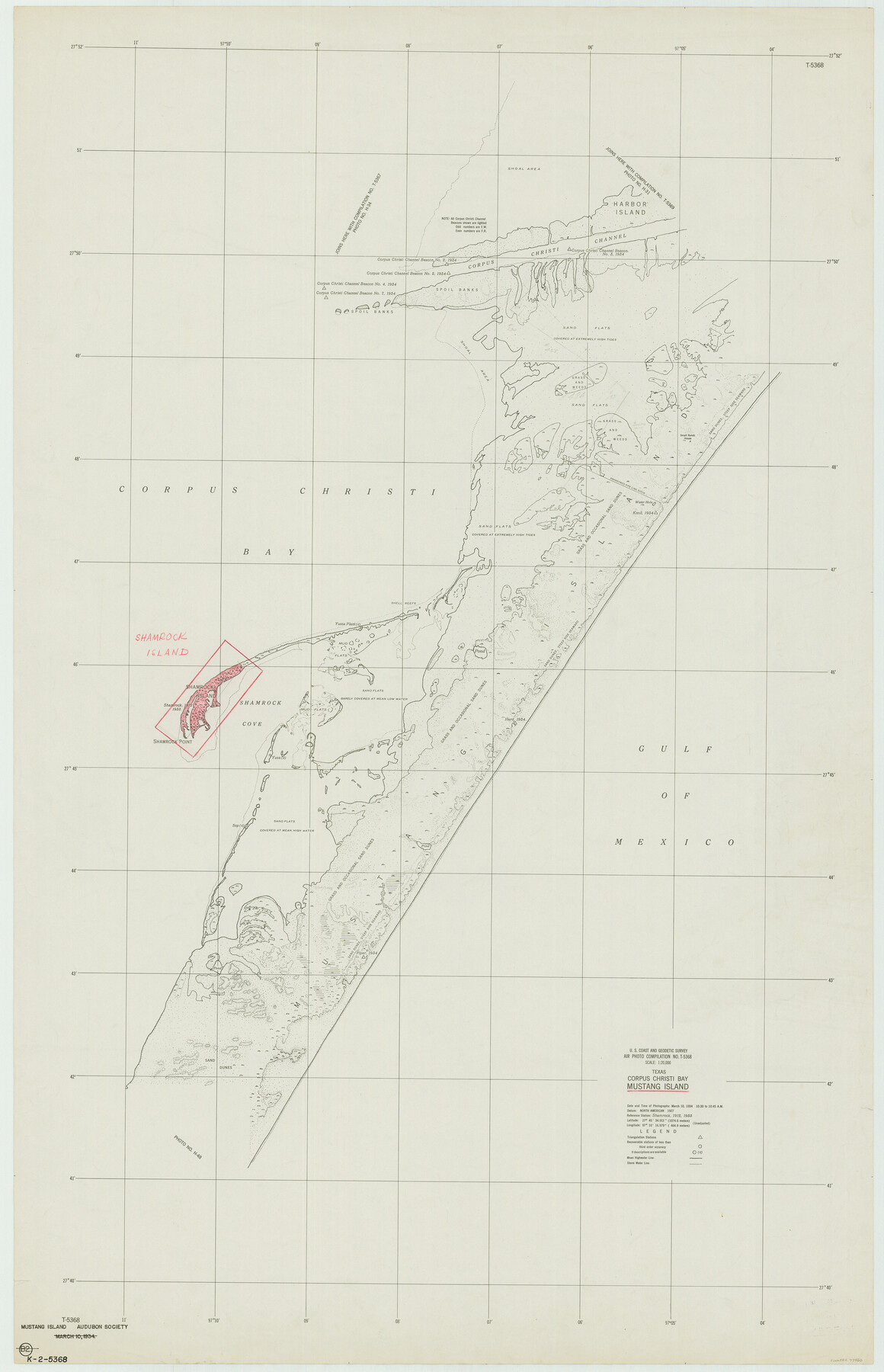
Texas, Corpus Christi Bay, Mustang Island
K-2-5368
-
Map/Doc
73460
-
Collection
General Map Collection
-
Object Dates
1934/3/10 (Creation Date)
-
Counties
Nueces
-
Subjects
Nautical Charts
-
Height x Width
48.6 x 31.4 inches
123.4 x 79.8 cm
Part of: General Map Collection
Crosby County Sketch File 35

Print $4.00
- Digital $50.00
Crosby County Sketch File 35
Size 8.5 x 12.1 inches
Map/Doc 20106
Hemphill County Working Sketch 34

Print $40.00
- Digital $50.00
Hemphill County Working Sketch 34
1976
Size 33.9 x 64.2 inches
Map/Doc 66129
Hunt County Sketch File 1

Print $4.00
- Digital $50.00
Hunt County Sketch File 1
1853
Size 7.6 x 5.1 inches
Map/Doc 27081
Grayson County Rolled Sketch 3

Print $20.00
- Digital $50.00
Grayson County Rolled Sketch 3
1952
Size 33.7 x 46.1 inches
Map/Doc 9666
Lubbock County Boundary File 6

Print $58.00
- Digital $50.00
Lubbock County Boundary File 6
Size 4.7 x 7.0 inches
Map/Doc 56494
[Surveys in Austin's Colony along the San Antonio Road and the Brazos and Yegua Rivers]
![203, [Surveys in Austin's Colony along the San Antonio Road and the Brazos and Yegua Rivers], General Map Collection](https://historictexasmaps.com/wmedia_w700/maps/203.tif.jpg)
Print $20.00
- Digital $50.00
[Surveys in Austin's Colony along the San Antonio Road and the Brazos and Yegua Rivers]
1831
Size 30.8 x 19.1 inches
Map/Doc 203
Pecos County Sketch File 2

Print $20.00
- Digital $50.00
Pecos County Sketch File 2
1880
Size 12.7 x 8.2 inches
Map/Doc 33652
Brooks County Rolled Sketch 7

Print $20.00
- Digital $50.00
Brooks County Rolled Sketch 7
1916
Size 28.5 x 30.4 inches
Map/Doc 5336
Dickens County Sketch File 2a

Print $4.00
- Digital $50.00
Dickens County Sketch File 2a
1884
Size 14.2 x 8.9 inches
Map/Doc 20950
Foard County Working Sketch 10

Print $20.00
- Digital $50.00
Foard County Working Sketch 10
1977
Size 32.0 x 43.7 inches
Map/Doc 69201
San Patricio County Rolled Sketch 38

Print $20.00
- Digital $50.00
San Patricio County Rolled Sketch 38
1950
Size 15.6 x 15.7 inches
Map/Doc 7588

You may also like

Leon County Sketch File 22

Print $24.00
- Digital $50.00
Leon County Sketch File 22
Size 12.8 x 8.8 inches
Map/Doc 29772
Map of Cameron, Hidalgo and half of Starr County of Texas

Print $20.00
- Digital $50.00
Map of Cameron, Hidalgo and half of Starr County of Texas
1900
Size 42.4 x 30.3 inches
Map/Doc 3150
Map of Kinney County

Print $20.00
- Digital $50.00
Map of Kinney County
1863
Size 31.4 x 29.7 inches
Map/Doc 3774
Flight Mission No. DCL-6C, Frame 51, Kenedy County

Print $20.00
- Digital $50.00
Flight Mission No. DCL-6C, Frame 51, Kenedy County
1943
Size 18.6 x 22.4 inches
Map/Doc 85893
Coleman County Working Sketch 17

Print $20.00
- Digital $50.00
Coleman County Working Sketch 17
1952
Size 24.8 x 29.2 inches
Map/Doc 68083
Map of Callahan Co[unty]
![88916, Map of Callahan Co[unty], Library of Congress](https://historictexasmaps.com/wmedia_w700/maps/88916.tif.jpg)
Print $20.00
Map of Callahan Co[unty]
1879
Size 24.7 x 18.5 inches
Map/Doc 88916
Garza County Sketch File C2

Print $6.00
- Digital $50.00
Garza County Sketch File C2
1900
Size 10.3 x 8.4 inches
Map/Doc 24019
Flight Mission No. BRA-8M, Frame 115, Jefferson County

Print $20.00
- Digital $50.00
Flight Mission No. BRA-8M, Frame 115, Jefferson County
1953
Size 18.6 x 22.2 inches
Map/Doc 85611
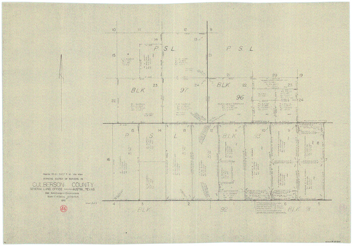
Culberson County Working Sketch 46
Print $20.00
- Digital $50.00
Culberson County Working Sketch 46
1971
Size 25.9 x 37.4 inches
Map/Doc 68500
Grimes County Working Sketch 5

Print $40.00
- Digital $50.00
Grimes County Working Sketch 5
1949
Size 43.6 x 83.2 inches
Map/Doc 63296
Webb County Working Sketch 88

Print $20.00
- Digital $50.00
Webb County Working Sketch 88
1982
Size 24.2 x 19.7 inches
Map/Doc 72455